
La Boissière-École
| La Boissière-École | ||
|---|---|---|
.svg)
|
|
|
| region | Île-de-France | |
| Department | Yvelines | |
| Arrondissement | Rambouillet | |
| Canton | Rambouillet | |
| Community association | Rambouillet Territoires | |
| Coordinates | 48 ° 41 ′ N , 1 ° 39 ′ E | |
| height | 126-184 m | |
| surface | 25.06 km 2 | |
| Residents | 765 (January 1, 2017) | |
| Population density | 31 inhabitants / km 2 | |
| Post Code | 78125 | |
| INSEE code | 78077 | |
 Town hall (Mairie) of La Boissière-École |
||

La Boissière-École is a French commune with a population of 765 (as at 1st January 2017) in the department of Yvelines in the region Ile-de-France . It belongs to the arrondissement of Rambouillet and the canton of Rambouillet . The inhabitants are called Boissériens .
geography
La Boissière-École is located about 54 kilometers west-southwest of Paris and about 13 kilometers east-northeast of Rambouillet . The river Maltorne , which drains to the Eure , has its source in the municipality . La Boissière-École is surrounded by the neighboring communities of Adainville in the north, Condé-sur-Vesgre in the north and northeast, Saint-Léger-en-Yvelines in the northeast, Poigny-la-Forêt in the east, Hermeray in the south and southeast, Mittainville in the south , Faverolles to the west and Le Tartre-Gaudran and La Hauteville to the northwest.
Population development
| year | 1962 | 1968 | 1975 | 1982 | 1990 | 1999 | 2006 | 2013 |
| Residents | 446 | 412 | 461 | 528 | 655 | 725 | 771 | 757 |
| Source: Cassini and INSEE | ||||||||
Attractions
See also: List of Monuments historiques in La Boissière-École
- Saint-Barthélemy Church, built in 1892
- Castle, built between 1853 and 1857
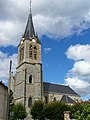
Saint Barthélemy Church

lock


literature
- Le Patrimoine des Communes des Yvelines. Flohic Editions, Volume 2, Paris 2000, ISBN 2-84234-070-1 , pp. 706-708.