
Senlisse
| Senlisse | ||
|---|---|---|
|
||
| region | Île-de-France | |
| Department | Yvelines | |
| Arrondissement | Rambouillet | |
| Canton | Maurepas | |
| Community association | Haute Vallée de Chevreuse | |
| Coordinates | 48 ° 41 ′ N , 1 ° 59 ′ E | |
| height | 88-179 m | |
| surface | 7.9 km 2 | |
| Residents | 491 (January 1, 2017) | |
| Population density | 62 inhabitants / km 2 | |
| Post Code | 78720 | |
| INSEE code | 78590 | |
| Website | http://www.commune-de-senlisse.fr/ | |
 Senlisse Town Hall (Mairie) |
||

Senlisse is a French municipality with 491 inhabitants (as of January 1 2017) in the department of Yvelines in the region Ile-de-France . It belongs to the arrondissement of Rambouillet and the canton of Maurepas (until 2015: canton of Chevreuse ). The inhabitants are called Senlissois .
geography
The municipality is part of the Haute Vallée de Chevreuse Regional Nature Park . Senlisse is located about 32 kilometers southwest of Paris and is surrounded by the neighboring communities Dampierre-en-Yvelines in the north, Choisel in the east and southeast, Cernay-la-Ville in the south, Auffargis in the west and Les Essarts-le-Roi in the northwest.
Population development
| year | 1962 | 1968 | 1975 | 1982 | 1990 | 1999 | 2006 | 2011 |
| Residents | 403 | 380 | 435 | 413 | 425 | 484 | 533 | 534 |
| Source: Cassini and INSEE | ||||||||
Attractions
- Saint-Denis church from the 13th century
- La Cour-Senlisse castle from the 17th century, monument historique
- Wash house
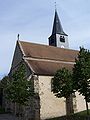
Saint-Denis church

La Cour-Senlisse Castle


literature
- Le Patrimoine des Communes des Yvelines. Volume 1, Flohic Editions, Paris 2000, ISBN 2-84234-070-1 , pp. 198-200.
Web links
Commons : Senlisse - collection of images, videos and audio files