Perdreauville
| Perdreauville | ||
|---|---|---|
|
|
||
| region | Île-de-France | |
| Department | Yvelines | |
| Arrondissement | Mantes-la-Jolie | |
| Canton | Bonnières-sur-Seine | |
| Community association | Grand Paris Seine et Oise | |
| Coordinates | 48 ° 58 ′ N , 1 ° 38 ′ E | |
| height | 40-151 m | |
| surface | 11.18 km 2 | |
| Residents | 632 (January 1, 2017) | |
| Population density | 57 inhabitants / km 2 | |
| Post Code | 78200 | |
| INSEE code | 78484 | |
| Website | http://www.perdreauville.fr/ | |
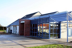
 Town Hall ( Mairie ) of Perdreauville |
||
Perdreauville is a French municipality with 632 inhabitants (as of January 1 2017) in the Yvelines department in the region Ile-de-France . It belongs to the arrondissement of Mantes-la-Jolie and the canton of Bonnières-sur-Seine . The inhabitants call themselves Perdreauvillois .
geography
Perdreauville is located about 50 kilometers west-northwest of Paris in the Seine valley . Perdreauville is surrounded by the neighboring municipalities of Rosny-sur-Seine in the north, Jouy-Mauvoisin in the east and northeast, Fontenay-Mauvoisin in the east, Favrieux in the southeast, Le Tertre-Saint-Denis in the south, Ménerville in the west and southwest, Bréval and Boissy -Mauvoisin to the west and Saint-Illiers-la-Ville to the west and northwest.
Population development
| 1962 | 1968 | 1975 | 1982 | 1990 | 1999 | 2006 | 2012 | |
|---|---|---|---|---|---|---|---|---|
| 211 | 213 | 270 | 369 | 401 | 536 | 589 | 632 | |
| Sources: Cassini and INSEE | ||||||||
Attractions
- Saint-Martin church, old chapel of the mansion from the 11th century, alterations from the 16th century
- Apremont mansion
- Ruins of the Les Beurons castle
literature
- Le Patrimoine des Communes des Yvelines. Volume 1, Flohic Editions, Paris 2000, ISBN 2-84234-070-1 , pp. 120-122.
Web links
Commons : Perdreauville - collection of images, videos and audio files
- Monuments historiques (objects) in Perdreauville in the base Palissy of the French Ministry of Culture
