Saint-Martin-la-Garenne
| Saint-Martin-la-Garenne | ||
|---|---|---|

|
|
|
| region | Île-de-France | |
| Department | Yvelines | |
| Arrondissement | Mantes-la-Jolie | |
| Canton | Limay | |
| Community association | Grand Paris Seine et Oise | |
| Coordinates | 49 ° 2 ′ N , 1 ° 41 ′ E | |
| height | 9–152 m | |
| surface | 15.75 km 2 | |
| Residents | 975 (January 1, 2017) | |
| Population density | 62 inhabitants / km 2 | |
| Post Code | 78520 | |
| INSEE code | 78567 | |
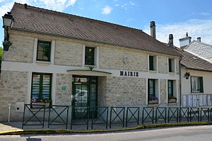
 Mairie Saint-Martin-la-Garenne |
||
Saint-Martin-la-Garenne is a commune on the right bank of the Seine in France . It belongs to the Île-de-France region , the Yvelines department , the Mantes-la-Jolie arrondissement and the Limay canton . To the west of the municipality is the lake "Port de l'Ilon", which is connected to the Seine. There is a boat harbor on the south bank. The river forms a meander and delimits Saint-Martin-la-Garenne in the northwest. The neighboring communities are Méricourt and Mousseaux-sur-Seine in the north-west, Moisson in the north, Vétheuil in the north-east, Follainville-Dennemont in the south-east and Guernes in the south-west.
history
It is known that in 1101 the settlement was called "Sanctus Matinus".
Population development
| year | 1962 | 1968 | 1975 | 1982 | 1990 | 1999 | 2009 | 2014 |
|---|---|---|---|---|---|---|---|---|
| Residents | 370 | 360 | 488 | 627 | 654 | 740 | 908 | 986 |
Attractions
See also: List of Monuments historiques in Saint-Martin-la-Garenne
- Saint Martin Church
- Lavoir (wash house)
- War memorial
literature
- Le Patrimoine des Communes des Yvelines. Volume 1, Flohic Editions, Paris 2000, ISBN 2-84234-070-1 , pp. 388-389.

