
Attnang
|
Attnang ( district ) locality |
|||
|---|---|---|---|
|
|||
| Basic data | |||
| Pole. District , state | Vöcklabruck (VB), Upper Austria | ||
| Judicial district | Vöcklabruck | ||
| Pole. local community | Attnang-Puchheim | ||
| Coordinates | 48 ° 0 '48 " N , 13 ° 43' 22" E | ||
| height | 416 m above sea level A. | ||
| Residents of the village | 3356 (January 1, 2020) | ||
| Building status | 683 (2001 ) | ||
| Post Code | 4800 | ||
| prefix | + 43/7674 | ||
| Official website | |||
| Statistical identification | |||
| Locality code | 12400 | ||
| Counting district / district | Attnang-Zentrum, Attnang-Nord, Attnang-West (41703 000, 001, 002) | ||
| Parts of the city also in the Niederstraß counting district (003) Source: STAT : Local directory ; BEV : GEONAM ; DORIS |
|||

Attnang is a place in the Vöcklatal of the Hausruckviertel of Upper Austria , and the capital and locality of the Attnang-Puchheim municipality in the Vöcklabruck district .
location
Attnang is now a town and includes around 700 buildings with 3500 inhabitants. It extends on the terrace between Kohlaichbach and Redlbach / Lehbach , along the Attnang-Puchheim train station and Bundesstraße 1 Wiener Straße .
The historic town center was in the north, on the Redlbach, where the Salzburger Strasse / Linzer Strasse , the old trunk road, crosses it, between the Spitzberg and the Hargl hill - it is now called Alt-Attnang . There is also the old parish church Attnang St. Martin , and the local cemetery is to the west of it.
Today's town center, originally Neu-Attnang at the train station, with the parish church of Hl. Geist and the town hall , was largely rebuilt after 1945 and extends between Bahnhofstraße (B 1), Römerstraße and Spitzberg.
On the other side of the train station, on Salzburger Straße , there are other districts, the boundaries to the town of Puchheim and Niederstraße are not recognizable.
Neighboring towns and cities:
| Hohenbaumgarten | Redlham (Gem. Redlham) | |
| Steinhübl |
.svg)
|
Niederstrasse |
| Puchheim |
Puchheimer Au ∗ Wankham (Ortsch., Gem. Regau ) |
Sicking (Ortsch., Gem. Desselbrunn ) |
- ∗ Puchheimer Au is part of the village of Puchheim, so Wankham is not directly adjacent
history

Attnang was originally a small settlement. It is first mentioned as Otenang in 1242 and had around 40 buildings around 1800 and around 120 buildings around 1900. However, it was already of political importance in the Middle Ages and was the seat of the Attnang office of the Wartenburg rule . It was also always larger than the old community capital Puchheim, to which it was assigned when the political communities were established after 1849 .
Even before the turn of the century won Attnang as the location of the station of kk privileged Empress Elisabeth Railway in importance as a coal trading center of Niederstrasser train to Thomasroith , and from 1877 to the time of the upcoming summer increasingly important node with the Crown Prince Rudolf Railway (today Salzkammergutbahn ): Between 1890 and 1910 the population tripled to over 2000 inhabitants. In 1912 the community name Puchheim was changed to Attnang-Puchheim due to the growing importance of the place .
On April 21, 1945 the area around the station was devastated by US bombing raids. After the end of the war, the town center was rebuilt. With the relocation of the municipal office to Neu-Attnang, Attnang became the main town of the market town from 1955 and, from 1990, the township .
| country | Kgr.Bavaria | Crown land of Austria above the Enns | (1.) Rep. Ö. | German rich | (2.) Republic of Austria | |||||||||||||
|---|---|---|---|---|---|---|---|---|---|---|---|---|---|---|---|---|---|---|
| year | 1811 | 1825 | 1869 | 1880 | 1890 | 1900 | 1910 | 1923 | 1934 | 1939 | 1951 | 1961 | 1971 | 1981 | 1991 | 2001 | 2011 | 2016 |
| Residents | 214 | 319 | 433 | 634 | 1153 | 2232 | 2566 | 2705 | 2642 | 3152 | 3384 | 3580 | 3586 | 3452 | 3412 | 3291 | 3329 | |
| building | 42 | 43 | 53 | 65 | 71 | 122 | 209 | 226 | 296 | 316 | 410 | 490 | 607 | 642 | 683 | |||
- Before 1800, for the Duchy of Austria or the Principality / Crown Land of Austria above the Enns , no independent censuses are documented; in 1649 there are 51 houses for the Attnang office.
Attractions

Old parish church of St. Martin

Attnang local cemetery, gate wall
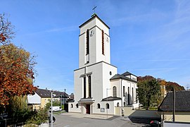
New Parish Church of the Holy Spirit

Old engine shed at the station


Personalities
Born in Attnang-Puchheim
- Franz Koch (1888–1969), Germanist, literary historian and university professor
- Max Lammer (1905–1966), actor
- Edith Dobesberger (1925–2002), politician and teacher, member of the National Council
- Ludwig Bieringer (* 1943), politician, federal councilor and mayor of Wals-Siezenheim
- Gerhard Fitzinger (1947–2016), composer, music teacher and church musician
- Carola Mair (* 1962), documentary filmmaker and screenwriter
- Martin Schermaier (* 1963), legal scholar and legal historian, university lecturer
- Angelika Winzig (* 1963), politician and entrepreneur, member of the European Parliament
- Hannes Maxwald (* 1968), motorcycle racer
With reference to Attnang-Puchheim
- Bruno Primetshofer (1929–2014), Roman Catholic clergyman, canon lawyer and university lecturer, grew up in Attnang-Puchheim
- Oskar Aichinger (* 1956), composer and pianist of modern creative jazz, grew up in Attnang-Puchheim
- Manfred Hiptmair (* 1965), judoka, Olympic participant, fought for the JSV Attnang
Web links
- Community website
- 41703 - Attnang-Puchheim. Community data, Statistics Austria .
Individual evidence
- ↑ Helmut Böhm: 1945 - the day of tears. Attnang-Puchheim in the hail of bombs from two US air fleets. Documentation based on the latest research results. Moserbauer, Ried im Innkreis 2007. ISBN 978-3-902121-86-8 .
-
^ Kurt Klein (edit.): Historical local dictionary . Statistical documentation on population and settlement history. Ed .: Vienna Institute of Demography [VID] d. Austrian Academy of Sciences . Upper Austria Part 2, Attnang
, p.
104 ( online document , explanations . Suppl . ; both PDF - oD [updated]). Special references: * 1811: census of the Bavarian administration of the Salzach district ( Montgelas census ) . In: Franz Xaver Weilmeyr: Topographisches Lexikon vom Salzach-Kreis . 1812.
- 1825 military conscription 1823/30; quoted from Benedikt Pillwein: History, geography and statistics of the Archduchy of Austria ob der Enns and the Duchy of Salzburg. 1827/32; New edition 1843
- 1869: Statistical Central Commission (ed.): Local repertories of the kingdoms and countries represented in the Austrian Imperial Council . 1871 ff
- 1880, 1890: Statistical Central Commission: Special local repertories of the kingdoms and countries represented in the Austrian Imperial Council . 1883 resp. 1892 ff
- 1900: Statistical Central Commission: Community lexicon of the kingdoms and countries represented in the Reichsrat. 1903 ff
- 1910: Central Statistical Commission: Special Repertories. 1915 ff
- 1923: Federal Statistical Office / Austrian Central Statistical Office (ed.): Directory of places . (Results of the census).
- 1934: Federal Statistical Office (edit.): Results of the census. 1935
- 1939: Official municipality register for the German Reich based on the 1939 census . Published by the
- 1951 and later: Austrian Central Statistical Office / Statistics Austria (Ed.): Ortverzeichnis . (Results of the census).
- ↑ Grüll Georg: Farmhouse and Meierhof. Research on the history of Upper Austria 13, 1975, p. 122; quoted from the historical local dictionary

Cadastral municipality: Attnang-Puchheim
Locations: Aham | Aichet | Attnang | Hohenbaumgarten | Landertsham | Niederstrasse | Oberstrasse | Puchheim | Sonnleithen | Steinhübl
City: Attnang | Villages: Niederstraß · Oberstraß · Puchheim | Hamlet: Landertsham | Rotten: Aham · Aichet · Hohenbaumgarten · Puchheimer Au · Sonnleithen · Steinhübl | Other locations: Alt-Attnang · Neu-Attnang
Counting district: Attnang center | Attnang-North | Attnang-West | Niederstrasse | Puchheim-Ost | Puchheim-West - Oberstrasse