
Friedenfels
| coat of arms | Germany map | |
|---|---|---|

|
Coordinates: 49 ° 53 ' N , 12 ° 6' E |
|
| Basic data | ||
| State : | Bavaria | |
| Administrative region : | Upper Palatinate | |
| County : | Tirschenreuth | |
| Height : | 537 m above sea level NHN | |
| Area : | 16.28 km 2 | |
| Residents: | 1223 (Dec. 31, 2019) | |
| Population density : | 75 inhabitants per km 2 | |
| Postal code : | 95688 | |
| Area code : | 09683 | |
| License plate : | TIR, KEM | |
| Community key : | 09 3 77 118 | |
| LOCODE : | DE F5N | |
| Community structure: | 12 districts | |
| Address of the municipal administration: |
Gemmingen-Str. 23 95688 Friedenfels |
|
| Website : | ||
| Mayor : | Gottfried Härtl ( CSU ) | |
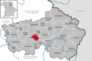
| Location of the community of Friedenfels in the Tirschenreuth district | ||
  |
||

Friedenfels (Bavarian: Frienfels) is a municipality in the Upper Palatinate district of Tirschenreuth . The main town of the same name is a state-approved resort on the southern slope of the Steinwald Nature Park .

Community structure
There are 12 parish parts:
|
The municipality includes the following districts: Bärnhöhe, Friedenfels, Voitenthan.
history
Until the 19th century
The place has grown together from the previously independent villages of Frauenreuth, Schönfuß, Trettmanns and Öd. Its name is derived from the Friedenfels Castle. The often mentioned alleged first mention in 1553 cannot be proven in the archives. The Friedenfels Castle was rather built after the division of the estate between the brothers Christoph and Friedrich Sittich Notthracht von Weißenstein in 1586. While Christoph had received the Thumsenreuth Castle , Friedrich Sittich built a new castle on the hill above Schönfuß. The name of Schloss Friedenfels is linked to the quarrel between the brothers Christoph and Friedrich Sittich Notthracht, of whom their guardian once said it would not do any good if they lived together in one house, even if they “had two special kitchens”. The younger of the two was happy to have finally found peace with his brother after the division of the estate and therefore called his new castle Friedenfels.
The Friedenfels estate remained in the hands of the von Notthracht family until 1882 , when it came to the Stuttgart industrialist Gustav von Siegle and finally, through his daughter, to the Barons von Gemmingen-Hornberg .
Incorporations
In 1939 the previously independent community of Bärnhöhe was incorporated. On January 1, 1978, parts of the dissolved Voitenthan community were added.
Population development
Between 1988 and 2018, the population fell from 1437 to 1241 by 196 or 13.6%.
coat of arms
|
|
Blazon : “Under a golden shield head, inside a blue bar, in blue a three-part silver rock mountain, on each of the outer tips of which there is a silver spruce; between them a golden stonemason hammer. "
The municipality has had the coat of arms since 1957. |
Culture and sights

The Friedenfels castle is surrounded by a park; It was given its present-day appearance after a reconstruction according to plans by the Munich architect Emanuel von Seidel in 1900. Friedenfels Castle was owned by the Freiherr Notthracht von Weißenstein until 1882; today it is owned by the Barons von Gemmingen-Hornberg . The palace and park are privately owned and cannot be visited.
The Catholic Church of Maria Immaculata, which was added to the palace complex, emerged from the palace chapel built in 1684 by Georg Rudolf Notthracht Freiherr von Weißenstein. Around 1870 the church, which had become too small, had to give way to a new neo-Gothic building, which was enlarged again in 1937/38 and thus got its current appearance. The interior is spanned by a wooden barrel construction; the furnishings are neo-Gothic-Byzantine. An epitaph attached to the outside of the church commemorates Freiherr Georg Rudolff Notthracht (* January 14, 1660 - † May 28, 1714), the founder of the Friedenfels Castle Chapel, and his wife Anna Sophia Barbara Notthracht, née Freiin von Sparneck (* 24 October 1675 - March 6, 1729).
A specialty of Friedenfels is the Notthaidische Waldfriedhof, located a little outside the town. In 1878, Baron Maximilian Joseph von Notthracht donated a family funeral on the so-called Muttergottesbühl. After the family members buried in the Thumsenreuth cemetery in the 19th century had been exhumed the previous night, the Notthaffische Waldfriedhof was inaugurated on April 16, 1878 by the parish clergy of Erbendorf and the beneficiary Georg Bissinger from Friedenfels, and the remains brought back from Thumsenreuth surrendered to the consecrated earth. Each grave site was provided with a grave monument from the Friedenfelser Syenitschleiferei . Twelve members of the Notthracht family found their final resting place here.
Soil monuments
Natural monuments
Friedenfels borders the Steinwald Nature Park .
Economy and Infrastructure
traffic
From 1894 to 1958, Friedenfels was the terminus of a narrow-gauge industrial railway , the Reuth – Friedenfels railway line .

Established businesses
- Friedenfels Castle Brewery
Public facilities
- outdoor pool
- kindergarten
- Friedenfels primary school
- Youth room Exile
- Altenstube Steinwaldhalle
- Day nursery
education
- Friedenfels primary school
literature
- Harald Stark : The Notthracht family - looking for traces in Egerland, Bavaria and Swabia . Weißenstadt 2006, ISBN 3-926621-46-X .
Web links
Individual evidence
- ↑ "Data 2" sheet, Statistical Report A1200C 202041 Population of the municipalities, districts and administrative districts 1st quarter 2020 (population based on the 2011 census) ( help ).
- ↑ contact person. Friedenfels parish, accessed on July 6, 2020 .
- ↑ http://www.bayerische-landesbibliothek-online.de/orte/ortssuche_action.html ? Anzeige=voll&modus=automat&tempus=+20111108/085002&attr=OBJ&val= 1080
- ^ Wilhelm Volkert (ed.): Handbook of Bavarian offices, communities and courts 1799–1980 . CH Beck, Munich 1983, ISBN 3-406-09669-7 , p. 580 .
- ^ Federal Statistical Office (ed.): Historical municipality directory for the Federal Republic of Germany. Name, border and key number changes in municipalities, counties and administrative districts from May 27, 1970 to December 31, 1982 . W. Kohlhammer GmbH, Stuttgart / Mainz 1983, ISBN 3-17-003263-1 , p. 663 .
- ^ Entry on the Friedenfels coat of arms in the database of the House of Bavarian History

Bad Neualbenreuth | Bärnau | Fire | Ebnath | Erbendorf | Falkenberg | Friedenfels | Fuchsmühl | Immenreuth | Kastl | Kemnath | Konnersreuth | Krummennaab | Kulmain | Leonberg | Mähring | Mitterteich | Neusorg | Pechbrunn | Plößberg | Pullenreuth | Reuth near Erbendorf | Tirschenreuth | Waldershof | Waldsassen | Wiesau