Genoa – Ventimiglia railway line
| Genoa – Ventimiglia | |||||||||||||||||||||||||||||||||||||||||||||||||||||||||||||||||||||||||||||||||||||||||||||||||||||||||||||||||||||||||||||||||||||||||||||||||||||||||||||||||||||||||||||||||||||||||||||||||||||||||||||||||||||||||||||||||||||||||||||||||||||||||||||||||||||||||
|---|---|---|---|---|---|---|---|---|---|---|---|---|---|---|---|---|---|---|---|---|---|---|---|---|---|---|---|---|---|---|---|---|---|---|---|---|---|---|---|---|---|---|---|---|---|---|---|---|---|---|---|---|---|---|---|---|---|---|---|---|---|---|---|---|---|---|---|---|---|---|---|---|---|---|---|---|---|---|---|---|---|---|---|---|---|---|---|---|---|---|---|---|---|---|---|---|---|---|---|---|---|---|---|---|---|---|---|---|---|---|---|---|---|---|---|---|---|---|---|---|---|---|---|---|---|---|---|---|---|---|---|---|---|---|---|---|---|---|---|---|---|---|---|---|---|---|---|---|---|---|---|---|---|---|---|---|---|---|---|---|---|---|---|---|---|---|---|---|---|---|---|---|---|---|---|---|---|---|---|---|---|---|---|---|---|---|---|---|---|---|---|---|---|---|---|---|---|---|---|---|---|---|---|---|---|---|---|---|---|---|---|---|---|---|---|---|---|---|---|---|---|---|---|---|---|---|---|---|---|---|---|---|---|---|---|---|---|---|---|---|---|---|---|---|---|---|---|---|---|---|---|---|---|---|---|---|---|---|---|---|---|---|---|---|---|
| Route number (RFI) : | 74 (Genoa – Savona) 75 (Savona – Ventimiglia) |
||||||||||||||||||||||||||||||||||||||||||||||||||||||||||||||||||||||||||||||||||||||||||||||||||||||||||||||||||||||||||||||||||||||||||||||||||||||||||||||||||||||||||||||||||||||||||||||||||||||||||||||||||||||||||||||||||||||||||||||||||||||||||||||||||||||||
| Course book series (IT) : | 25th | ||||||||||||||||||||||||||||||||||||||||||||||||||||||||||||||||||||||||||||||||||||||||||||||||||||||||||||||||||||||||||||||||||||||||||||||||||||||||||||||||||||||||||||||||||||||||||||||||||||||||||||||||||||||||||||||||||||||||||||||||||||||||||||||||||||||||
| Route length: | 147 km | ||||||||||||||||||||||||||||||||||||||||||||||||||||||||||||||||||||||||||||||||||||||||||||||||||||||||||||||||||||||||||||||||||||||||||||||||||||||||||||||||||||||||||||||||||||||||||||||||||||||||||||||||||||||||||||||||||||||||||||||||||||||||||||||||||||||||
| Gauge : | 1435 mm ( standard gauge ) | ||||||||||||||||||||||||||||||||||||||||||||||||||||||||||||||||||||||||||||||||||||||||||||||||||||||||||||||||||||||||||||||||||||||||||||||||||||||||||||||||||||||||||||||||||||||||||||||||||||||||||||||||||||||||||||||||||||||||||||||||||||||||||||||||||||||||
| Power system : | Overhead line 3 kV = | ||||||||||||||||||||||||||||||||||||||||||||||||||||||||||||||||||||||||||||||||||||||||||||||||||||||||||||||||||||||||||||||||||||||||||||||||||||||||||||||||||||||||||||||||||||||||||||||||||||||||||||||||||||||||||||||||||||||||||||||||||||||||||||||||||||||||
|
|||||||||||||||||||||||||||||||||||||||||||||||||||||||||||||||||||||||||||||||||||||||||||||||||||||||||||||||||||||||||||||||||||||||||||||||||||||||||||||||||||||||||||||||||||||||||||||||||||||||||||||||||||||||||||||||||||||||||||||||||||||||||||||||||||||||||
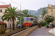
The Genoa – Ventimiglia line is a main line of the Italian State Railways Ferrovie dello Stato (FS). It leads from the Ligurian capital Genoa along the Riviera di Ponente to the state border with France and connects Genoa with the provincial capitals Savona and Imperia . In addition to the domestic trains, long-distance trains between Italy and France also run on the route. At the border station of Ventimiglia both the Italian and the French domestic trains end. The original, single-track line was in many places directly on the seashore and was considered one of the most scenic railway lines in Italy. The double-track upgraded line, which has been partially realized, runs largely in tunnels in the hinterland.
Original route
The route is characterized by difficult geographical conditions. The foothills of the Ligurian Alps and the Ligurian Apennines meet the sea on the Riviera di Ponente without a continuous coastal plain; existing coastal strips are densely built up.
The route was originally laid out as a single track and ran over large parts directly on the seashore, in shorter coastal tunnels or through localities. It was therefore one of the most scenic routes in Italy. However, the routing in the coastal towns, which are often characterized by tourism and which were cut by the tracks and partially separated from the sea, led to urban planning problems. At the sea, the route was exposed to coastal erosion .
Coming from Genoa, the line reached Savona in 1868 ; Continuous operation to Ventimiglia was started in 1872. Initially, the operation was carried out with steam locomotives .
electrification
In the first half of the 20th century, the line was electrified with three-phase current (3600 volts, 16 2/3 Hz). After the French state railway SNCF decided to convert the route from Ventimiglia to Marseille from direct current (1500 volts) to alternating current (25000 volts, 50 Hz), it was discussed to re-electrify the route west of Savona with this same power system. This would have given Italian industry, in particular the TIBB locomotive factory in Vado Ligure , a test track for this system. However, the project was not carried out. In May 1964 the section between Genoa and Savona, on January 8, 1967 that from Savona to Ventimiglia, was converted to the Italian direct current system (3000 volts).
Expansion and re-routing
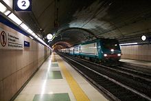
It soon became apparent that a single-track route did not meet the operational requirements. However, expansion to double track proved difficult. Until 1968, only the sections of the line in the municipality of Genoa, the one west of Ospedaletti and an eight-kilometer section between Loano and Albenga could receive a second track. In 1968 the opening of a new, double-track line between Genova Vesima and Varazze , and in 1969 between Genova Voltri and Genova Vesima. In 1977 the route between Varazze and Finale Ligure followed , in 2001 between San Lorenzo al Mare and Ospedaletti and on December 11, 2016 the new route between San Lorenzo al Mare and Andora . Large parts of these new lines run in tunnels; the original line has been abandoned on these sections. Due to the minimum curve radius of 2000 meters and the maximum gradient of 3 ‰, the maximum speed between San Lorenzo and Andora could be increased from 80–90 km / h to 180 km / h.
In the long term, a realignment between Andora and Finale Ligure is also planned - this would make the route consistently double-lane and faster, but would have lost its scenic charm.
Between Ospedaletti and San Lorenzo al Mare, the Pista ciclabile del Ponente ligure long-distance cycle path was created on the old route .
Incidents
On January 17, 2014, an Intercity on the Milan – Ventimiglia route hit a landslide in the Andora municipality; the route therefore had to be closed for several weeks.
Web links
Individual evidence
- ^ Impianti FS. In: I Treni No. 255 (January 2004), p. 8.
- ^ Impianti FS. In: I Treni No. 180 (March 1997), p. 7.
- ↑ Joachim von Rohr: Ligurian three-phase summer 1963. EK-Verlag, Freiburg 2014, ISBN 978-3-88255-469-4 , p. 31.
- ↑ Mario Bianchi: Attivo il raddoppio Andora - San Lorenzo. In: ferrovie.it. December 13, 2016, accessed August 1, 2017 (Italian).
- ↑ Website on the Pista ciclabile del Ponente ligure , accessed on August 1, 2017.


