Banín
| Banín | ||||
|---|---|---|---|---|
|
||||
| Basic data | ||||
| State : |
|
|||
| Region : | Pardubický kraj | |||
| District : | Svitavy | |||
| Area : | 1294 ha | |||
| Geographic location : | 49 ° 40 ′ N , 16 ° 27 ′ E | |||
| Height: | 454 m nm | |||
| Residents : | 318 (Jan. 1, 2019) | |||
| Postal code : | 568 02 | |||
| structure | ||||
| Status: | local community | |||
| Districts: | 1 | |||
| administration | ||||
| Mayor : | Jiří Švihel (as of 2006) | |||
| Address: | Banín 41 568 02 Svitavy 2 |
|||
| Municipality number: | 572560 | |||
The municipality of Banín (German Bohnau ) is located in Pardubický kraj . 310 inhabitants live on an area of 1,294 hectares .
history
The place Banín (popularly Banín, do Bajna, g Bajnu) is mentioned for the first time in 1291 as circa villam Banín, later again as villam Banyn et Nouam Belam, Banyns, Banina cum Filia.
After the Munich Agreement , the place was added to the German Empire and belonged to the district of Zwittau until 1945 .
Attractions
- Block constructions in the courtyard from the first half of the 19th century
- Cemetery with a gate bell and onion domes
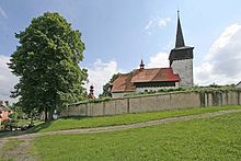
- Gothic church of St. Barbara from the beginning of the 14th century
Web links
Commons : Banín - collection of images, videos and audio files


