Nová Ves u Jarošova
| Nová Ves u Jarošova | ||||
|---|---|---|---|---|
|
||||
| Basic data | ||||
| State : |
|
|||
| Region : | Pardubický kraj | |||
| District : | Svitavy | |||
| Area : | 238 ha | |||
| Geographic location : | 49 ° 50 ' N , 16 ° 10' E | |||
| Height: | 454 m nm | |||
| Residents : | 70 (Jan. 1, 2019) | |||
| Postal code : | 570 01 | |||
| License plate : | E. | |||
| traffic | ||||
| Street: | Nové Hrady - Budislav | |||
| structure | ||||
| Status: | local community | |||
| Districts: | 1 | |||
| administration | ||||
| Mayor : | Tomáš Pechanec (as of 2018) | |||
| Address: | Nová Ves u Jarošova 41 570 01 Litomyšl |
|||
| Municipality number: | 572438 | |||
| Website : | www.obecnovaves.com | |||
Nová Ves u Jarošova (German Neudorf bei Jaroschau ) is a municipality in the Czech Republic . It is located five kilometers northeast of Proseč and belongs to the Okres Svitavy .
geography
Nová Ves u Jarošova is located on the right side above the valley of the Vranický potok in the Novohradská stupňovina ( Neuschlosser stepland ). The Škrabka (501 m nm) rises to the southeast. The Údolí Krounky a Novohradky nature park with the sandstone rock areas of Toulovcovy maštale and Městské maštale extends to the west along the Novohradka and its side valleys .
Neighboring towns are Příluka and Chotovice in the north, Makov , Lažany and Václavky in the northeast, Vidlatá Seč in the east, Chotěnov and Olšany in the southeast, Jarošov in the south, Vranice, Bor u Skutče and Zderaz in the southwest, Dudychov and Roudná Lhotaokrá in the west and Mhotaokrá Nové Hrady in the north-west.
history
Nová Ves was first mentioned in writing in 1559 as part of the Nový hrad estate . According to tradition, the village originally stood on Voštice square ; after the wooden chalets burned down there, the village should have been laid out under the new name Nová Ves at its current location. The landlords were the Žatecky von Weikersdorf, from 1580 the Popel von Lobkowitz , from 1604 the barons von Trautson and from 1749 the counts Harbuval-Chamaré . Between 1774 and 1777, Neuschloß Castle was built as the new mansion .
In 1835 the village of Neudorf or Nowawes , located in the Chrudim district , consisted of 36 houses in which 237 people lived. The parish was Neuschloß . Until the middle of the 19th century, Neudorf always remained subject to the rule of Neuschloß .
After the abolition of patrimonial made Nová Ves / Neudorf 1849 a district of the municipality Jarošov in the judicial district Leitomischl . From 1868 the village belonged to the political district of Leitomischl . In 1869 it had 229 inhabitants. Nová Ves broke away from Jarošov in the 1870s and formed a separate municipality with the districts Roudná and Vranice 2. díl. In 1900, 246 people lived in the 52 houses of the community, the center consisted of 40 houses and had 186 inhabitants. In 1921 the community had 261 inhabitants; 200 of them lived in Nová Ves (41 houses) and 61 in Vranice 2. díl (11 houses). The part of Roudná (6 houses) belonging to the municipality was not permanently inhabited. In 1924, the municipality received the official name extension u Jarošova to distinguish it from Nová Ves u Litomyšle . In 1930 the community had 243 inhabitants. In the course of the territorial reform of 1960 Nová Ves u Jarošova came to Okres Svitavy . In 1961 only 156 people lived in the community. In 1964 Nová Ves u Jarošova was incorporated into Jarošov. The population decline continued towards the end of the 20th century; from 129 (1970) the population decreased to 50 (1994). Since September 1st, 1990 the municipality of Nová Ves u Jarošova exists again.
Community structure
No districts are shown for the municipality of Nová Ves u Jarošova. The settlements Roudná ( Raudna ) and Vranice 2. díl ( Wranitz 2nd part ) belong to Nová Ves u Jarošova .
Attractions
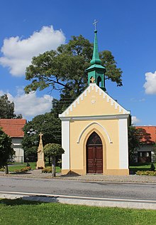
- Chapel of St. John of Nepomuk
- Memorial stone for the fallen of the First World War
- Memorial cross, erected in 1881
- Sandstone rock areas of Toulovcovy maštale and Městské maštale, west and south-west of the village
Web links
Individual evidence
- ↑ http://www.uir.cz/obec/572438/Nova-Ves-u-Jarosova
- ↑ Český statistický úřad - The population of the Czech municipalities as of January 1, 2019 (PDF; 7.4 MiB)
- ^ Johann Gottfried Sommer : The Kingdom of Bohemia; Represented statistically and topographically. Volume 5: Chrudimer Kreis. Prague 1837, p. 233


