Radiměř
| Radiměř | ||||
|---|---|---|---|---|
|
||||
| Basic data | ||||
| State : |
|
|||
| Region : | Pardubický kraj | |||
| District : | Svitavy | |||
| Area : | 2857 ha | |||
| Geographic location : | 49 ° 42 ' N , 16 ° 26' E | |||
| Height: | 485 m nm | |||
| Residents : | 1,118 (Jan 1, 2019) | |||
| Postal code : | 569 07 | |||
| administration | ||||
| Mayor : | Roman Satrapa | |||
| Address: | Radiměř 167 569 07 Radiměř |
|||
| Municipality number: | 578657 | |||
| Website : | www.obec-radimer.cz | |||
Radiměř (German Rothmühl ) is a municipality in Okres Svitavy in the Pardubice region . The street village stretches for about 8 kilometers. It was divided by the Rothmühler Bach into the market Mährisch Rothmühl and the village Böhmisch Rothmühl , which formed the historical Bohemian-Moravian border. The village has 1094 inhabitants (2014) and an area of 28.6 square kilometers. Radiměř lies in the landscape of the Schönhengstgau , the former largest German- speaking island in Bohemia and Moravia . The language island was only a few kilometers apart from the rest of the German-speaking area of the Sudetenland . Until the expulsion in 1945/46 , Böhmisch and Mährisch Rothmühl were mostly inhabited by Germans.
history
While the community of Rothmühl was first mentioned in a document in 1291, the parish was first mentioned in 1474. Mährisch Rothmühl had its own manor , which had its seat in a courtyard below the church. Böhmisch-Rothmühl was a colonist village with an inheritance court . These German colonists were summoned by Bohemian sovereigns in the 12th century to colonize and cultivate fallow land. Farmers, artisans, merchants and miners followed this recruitment. They came mainly from the Bavarian region, from Main and Eastern Franconia and the Upper Palatinate . The artificially created Mühlbach, which politically separated the two places from 1512 due to changed claims to rule, had a gradient of 180 meters over its entire length and enabled thirteen mills to be operated. The Böhmisch and Mährisch Rothmühl schools were separate, but not the parish , which belonged to the Moravian Church Province . From 1919 there was a community school for both districts, so that Rothmühl experienced a regional appreciation as a market town . In addition to agriculture, linen manufacture and the linen trade were guarantors for Rothmühl's economic development in the first half of the 19th century. With the gradual decline of the linen business, a number of Rothmühlers earned their living as workers. With the Munich Agreement in 1939, Rothmühl's separation into the Bohemian and Moravian administrations was abolished. On December 17, 1950, the Czech state finally merged the two places.
Bohemian Rothmühl
The village municipality of Böhmisch Rothmühl belonged to the district and judicial district Politschka in East Bohemia in 1930 and had 1,354 inhabitants, 1,312 of whom were German. There were two chapels in the village, consecrated to Saint John of Nepomuk and Saint Joseph .
Moravian Rothmühl
In 1930 the market town belonged to the Mährisch Trübau district and the judicial district of Zwittau in Central Moravia. It had 1,456 inhabitants, of which 1,408 were German. The next train station was in Greifendorf . Mährisch Rothmühl had the right to hold two markets a year. The richly decorated rococo church of St. Anna was built between 1771 and 1776.
coat of arms
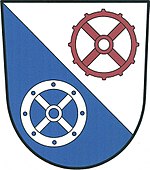
Blazon : obliquely divided by silver and blue. Above a four-spoke red, below a four-spoke silver mill wheel.
Views
people
- Kamil Prudil (1937-2006), painter and psychologist
- Hugo Jury (1887–1945), doctor and National Socialist politician
Varia
In the former Hallgarten town hall in 65375 Oestrich-Winkel is the Rothmühler Heimatmuseum, a facility that was set up by the Association for Displaced People .
literature
- Hans Jandl: Rothmühl and its residents. Attempt a documentation. Arno Jandl, Hallgarten (Rheingau) 1970.
- Hans Jandl: Rothmühl. A changing village. Arno Jandl, Hallgarten (Rheingau) 1972.
- Hans Jandl, Erna Jandl: Parochia Radmühlensis. Parish of Sankt Anna Rothmühl. R. Jandl, Hallgarten (Rheingau) 1979
Individual evidence
- ↑ Český statistický úřad - The population of the Czech municipalities as of January 1, 2019 (PDF; 7.4 MiB)
- ^ Rudolf Meixner: History of the Sudeten Germans. Preußler, Nuremberg 1983, ISBN 3-921332-97-4 , p. 14 ff.
- ↑ The Schönhengstgau , accessed on September 29, 2015
- ↑ Rothmuehler-Heimatmuseum , accessed on September 29, 2015


