Berguedà
| Berguedà | |
|---|---|

|
|

|
|
| The location of the Comarca Berguedà in Catalonia | |
| Basic data | |
| Province: | Barcelona |
| Main place: | Berga (Barcelona) |
| Surface: | 1184.9 km² |
| Residents: | 39,446 (2019) |
| Municipalities: | 31 |
The Comarca Berguedà is in the province of Barcelona of the Autonomous Community of Catalonia ( Spain ). The community association has an area of 1,185 km² and 39,446 inhabitants (2019).
location
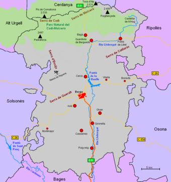
The association of municipalities is located in the north-eastern part of Catalonia, it borders in the north on the Comarca Cerdanya , in the east on Ripollès and Osona , in the south on Bages and in the west on Solsonès and Alt Urgell . Together with the comarcas Anoia , Bages, Osona and Solsonès, the region forms the territory of Comarques Central . The city of Barcelona is located about 80 km south-southeast.
The northern part of the district, the Alt Berguedà (German: Upper Berguedà), is located in the high mountain region of the Pyrenees . The Serra del Cadí ( 2430 m ) forms a natural border with the high valley of the Cerdanya . In the Sierra del Cadí there is also the Parc Natural del Cadí-Moixeró, founded in 1983, with one of the charismatic mountains of the Pyrenees: the double peaks of Pedraforca ( 2497 m ). The river Llobregat , which flows through the whole comarca from north to south and is the lifeline of the district, has its source at Castellar de n'Hug at an altitude of 1295 m . Shortly before the capital Berga, the Llobregat is dammed up in a dam, the Pantà de la Baells , to form a long lake with a capacity of 109.5 hm³. The 102 m high dam, built in 1976, is used to supply Barcelona with drinking water and to generate electricity. The southern part of the district, the Baix Berguedà (German: Unteres Berguedà), lies in the plain of the central Catalan valley. The capital Berga is also located there , it is almost exactly in the center of the comarca.
Attractions
Of the around 80 Romanesque churches that can be found in the comarca, Sant Quirze de Pedret (4 km from Berga), Sant Vicenç in Obiols, Santa Maria (near Avià ), Sant Miquel de Lillet (2 km from La Pobla de Lillet ) and San Juan de Cornudell near Castellar de N'Hug of particular interest.
economy
Until a few years ago, mining, which was now in crisis, played an important role. Traditional cattle breeding, agriculture and forestry are practiced almost exclusively as a sideline. Tourism is of increasing importance for hikers, mountaineers and skiers. The Rasos de Peguera ski area ( 2000 m ) is only 14 km from Berga .
Communities
Status: 2019
| local community | Pop. | Area (km²) |
local community | Pop. | Area (km²) |
local community | Pop. | Area (km²) |
||
|---|---|---|---|---|---|---|---|---|---|---|
| Avià | 2226 | 27.16 | Fígols | 42 | 29.67 | Quar | 53 | 37.74 | ||
| Bagà | 2138 | 43.11 | Gironella | 4826 | 6.83 | Sagas | 148 | 44.85 | ||
| Berga | 16,494 | 22.54 | Gisclareny | 25th | 36.60 | Balance | 274 | 66.97 | ||
| Borredà | 445 | 43.56 | Gósol | 206 | 56.33 | Sant Jaume de Frontanyà | 30th | 21.37 | ||
| Capolat | 94 | 34.31 | Guardiola de Berguedà | 908 | 61.43 | Sant Julià de Cerdanyola | 228 | 11.65 | ||
| Casserres | 1608 | 29.38 | Montclar | 136 | 22.28 | Santa Maria de Merles | 184 | 51.69 | ||
| Castell de l'Areny | 68 | 24.81 | Montmajor | 464 | 76.03 | Vallcebre | 250 | 27.85 | ||
| Castellar de n'Hug | 159 | 46.83 | Nou de Berguedà | 161 | 24.87 | Vilada | 416 | 22.45 | ||
| Castellar del Riu | 169 | 32.89 | Olvan | 854 | 35.41 | Viver i Serrateix | 168 | 66.74 | ||
| Cercs | 1145 | 47.20 | Pobla de Lillet | 1095 | 51.52 | |||||
| L'Espunyola | 254 | 35.35 | Puig-reig | 4178 | 46.16 |
See also
Web links
- Comarca website (Catalan)
- Association of municipalities (Catalan, Spanish, English, German, French, Italian)
- Berguedà Turisme (Catalan, Spanish, English, French)
- Alt Berguedà Turisme (Catalan, Spanish, English, French)
- gencat-Turisme (Catalan, Spanish, English, German, French)

