Brunn an der Wild
|
Brunn an der Wild
|
||
|---|---|---|
| coat of arms | Austria map | |
|
|
||
| Basic data | ||
| Country: | Austria | |
| State : | Lower Austria | |
| Political District : | horn | |
| License plate : | HO | |
| Surface: | 32.01 km² | |
| Coordinates : | 48 ° 42 ' N , 15 ° 31' E | |
| Height : | 442 m above sea level A. | |
| Residents : | 838 (January 1, 2020) | |
| Population density : | 26 inhabitants per km² | |
| Postal code : | 3595 | |
| Area code : | 02989 | |
| Community code : | 3 11 02 | |
| NUTS region | AT124 | |
| UN / LOCODE | AT BWD | |
| Address of the municipal administration: |
Schulstrasse 4 3595 Brunn an der Wild |
|
| Website: | ||
| politics | ||
| Mayoress : | Elisabeth Allram ( ÖVP ) | |
|
Municipal Council : ( 2020 ) (15 members) |
||
| Location of Brunn an der Wild in the Horn district | ||
| Source: Municipal data from Statistics Austria | ||
Brunn an der Wild is a municipality with 838 inhabitants (as of January 1, 2020) in the Horn district in Lower Austria .
geography
The street village of Brunn an der Wild is located in the Waldviertel in Lower Austria, about eleven kilometers west of Horn . The wild is the forest area to the north and west. The area of the municipality covers 32.03 square kilometers. 27.47 percent of the area is forested.
Community structure
The municipality includes the following ten localities (population in brackets as of January 1, 2020):
- Atzelsdorf (64)
- Brunn an der Wild (320)
- Dappach (61)
- Dietmannsdorf an der Wild (118) including Wildhäuser
- Frankenreith (16)
- Fürwald (32)
- Neukirchen an der Wild (100)
- St. Marein (67)
- Waiden (49)
- Wutzendorf (11)
The community consists of the cadastral communities Atzelsdorf, Brunn an der Wild, Dappach, Dietmannsdorf, Frankenreith, Fürwald, Neukirchen, St. Marein, Waiden and Wutzendorf.
The community is a member of the Taffa-Thaya-Wild region .
With the Lower Austria. Local structural improvements were merged municipalities Brunn an der Wild and Dappach the community Brunn an der Wild on January 1, 1968th
Neighboring communities
| Ludweis-Aigen | Irnfritz knives | |
| Göpfritz an der Wild |

|
St. Bernhard-Frauenhofen |
| Röhrenbach |
history
The municipality was already settled in the Neolithic .
Brunn an der Wild was first mentioned in a document in the second half of the 13th century. The cadastral community of Dappach was first mentioned in 1135, Dietmannsdorf an der Wild around 1180, Frankenreith 1252 and Neukirchen an der Wild 1076. Neukirchen an der Wild was owned by the Counts of Poigen in the second half of the 12th century and came into the first half of the 12th century to their branch family, the Counts of Poigen-Hohenburg-Wildberg . In Dietmannsdorf an der Wild there were iron and silver factories in the 15th and 16th centuries.
Population development
The population of Brunn an der Wild has been falling for many years. If the migration balance was strongly negative between 1981 and 1991 (−129), the population is currently falling due to a negative birth balance .

politics
The municipal council has 15 members.
- With the municipal council elections in Lower Austria in 1990, the municipal council had the following distribution: 14 ÖVP and 1 SPÖ.
- With the municipal council elections in Lower Austria in 1995, the municipal council had the following distribution: 13 ÖVP, 1 citizens' list and 1 FPÖ.
- With the municipal council elections in Lower Austria in 2000, the municipal council had the following distribution: 15 ÖVP.
- With the municipal council elections in Lower Austria in 2005 , the municipal council had the following distribution: 12 ÖVP and 3 SPÖ.
- With the municipal council elections in Lower Austria in 2010 , the municipal council had the following distribution: 13 ÖVP and 2 SPÖ.
- With the municipal council elections in Lower Austria in 2015 , the municipal council had the following distribution: 12 ÖVP and 3 SPÖ.
- With the municipal council elections in Lower Austria 2020 , the municipal council has the following distribution: 14 ÖVP and 1 SPÖ.
- mayor
- 1996 (?) - 2016 Josef Gumpinger (ÖVP)
- since 2016 Elisabeth Allram (ÖVP)
Culture and sights
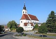
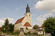
- Catholic parish church Neukirchen an der Wild hl. Martin: The church has a Romanesque tower and other Romanesque wall elements, as well as a Gothic choir. Its free-standing high altar dates from 1766. The parish church of St. Marein to St. Mary is a former pilgrimage church and incorporated into the Altenburg monastery. It is a baroque building on partly Gothic foundation walls. The rectory belonging to the parish church with structural elements from the 16th century is the former Sumarein Palace. To the north of Atzelsdorf there is a stone tower from the Middle Ages on a rock by the Taffa . There is a very beautiful and worth seeing cemetery in town.
- Catholic parish church St. Marein in Lower Austria hl. Maria: The former pilgrimage church is a basilical baroque building, which was built on the south side over Gothic foundation walls.
- Catholic parish church Dietmannsdorf an der Wild hl. Laurentius
- In the vicinity of St. Marein, the Greillenstein Castle or Altenburg Abbey and the everyday museum in Neupölla are tourist attractions. All of these destinations can be easily visited on a bike tour. In addition, St. Marein has a public bathing biotope and an inn with home-style cuisine.
- Regular events
- The traditional Advent market in St. Marein on the main square takes place every year on the last weekend in November.
economy
In 2010 there were 77 agricultural and forestry holdings, 41 of which were full-time farms. Fourteen factories employed 81 people in the manufacturing sector, mostly in the manufacture of goods. The service sector provided work for 112 people in 34 companies (as of 2011).
education
There is a kindergarten and a primary school in the community.
leisure
Brunn an der Wild is characterized by a wide range of leisure and sports opportunities. There is a bathing biotope in Dietmannsdorf, St. Marein and Brunn an der Wild. In 2003 the leisure facility with 2 tennis courts, a fun court, a swimming biotope and a clubhouse was built in Brunn.
traffic
- Rail: Brunn an der Wild has no rail connection. Nearby train stations are in Göpfritz an der Wild with connections via the Franz-Josefs-Bahn to Gmünd and Vienna , as well as in Horn an der Kamptalbahn . There are connections to Sigmundsherberg on the Franz-Josefs-Bahn and to Krems .
- Bus: There are bus connections from the community to Horn, Litschau, Waidhofen an der Thaya and direct connections to Vienna.
- Street: Brunn an der Wild is located at the intersection of Waldviertler Straße (B2) and Gföhler Straße (B32).
Personalities
- Robert N. Braun (1914–2007), general practitioner, honorary citizen and honorary ring holder of the community
Web links
- 31102 - Brunn an der Wild. Community data, Statistics Austria .
- Website of the municipality of Brunn an der Wild
Individual evidence
- ↑ Statistics Austria: Population on January 1st, 2020 by locality (area status on January 1st, 2020) , ( CSV )
- ↑ Statistics Austria: dissolutions or associations of municipalities from 1945
- ^ Statistics Austria, A look at the community of Brunn an der Wild, population development. Retrieved September 16, 2019 .
- ^ Result of the local council election 1995 in Brunn an der Wild. Office of the Lower Austrian State Government, March 30, 2000, accessed on April 16, 2020 .
- ^ Election result of the municipal council election 2000 in Brunn an der Wild. Office of the Lower Austrian State Government, February 4, 2005, accessed April 16, 2020 .
- ^ Result of the 2005 municipal council election in Brunn an der Wild. Office of the Lower Austrian State Government, March 4, 2005, accessed on April 16, 2020 .
- ^ Election result of the municipal council election 2010 in Brunn an der Wild. Office of the Lower Austrian State Government, October 8, 2010, accessed on April 16, 2020 .
- ^ Election result of the 2015 municipal council election in Brunn an der Wild. Office of the Lower Austrian State Government, December 1, 2015, accessed on April 16, 2020 .
- ↑ Results of the municipal council election 2020 in Brunn an der Wild. Office of the Lower Austrian State Government, January 26, 2020, accessed on April 16, 2020 .
- ^ Statistics Austria, A look at the municipality of Brunn an der Wild, agriculture and forestry operations. Retrieved September 16, 2019 .
- ^ Statistics Austria, A look at the community of Brunn an der Wild, workplaces. Retrieved September 16, 2019 .
- ^ Statistics Austria, A look at the community of Brunn an der Wild, employees. Retrieved September 16, 2019 .
- ↑ Brunn an der Wild community, school and kindergarten. Retrieved September 16, 2019 .
- ↑ OeBB route planner. Retrieved September 16, 2019 .
- ^ OeBB, station information, Brunn an der Wild. Retrieved September 16, 2019 .
- ↑ OpenStreetMap, Brunn an der Wild. Retrieved September 16, 2019 .


