Pulau Bum Bum
| Pulau Bum Bum | ||
|---|---|---|
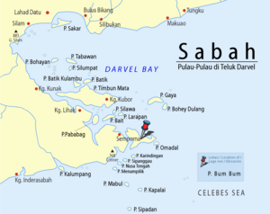
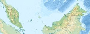
| Location of Pulau Bum Bum on the southeastern edge of Darvel Bay | ||
| Waters | Celebes Sea | |
| Geographical location | 4 ° 28 ′ N , 118 ° 41 ′ E | |
|
|
||
| length | 16 km | |
| width | 12.8 km | |
| surface | 45 km² | |
| Highest elevation | 20 m | |
| Residents | 20,000 444 inhabitants / km² |
|
Pulau Bum Bum (sometimes also Pulau Bum Bun ) is an island belonging to the easternmost Malaysian state of Sabah on the southeast side of Darvel Bay, which is open to the Celebes Sea . The island is located in the Semporna district of the Tawau Division . It is located about one kilometer east of Semporna and is the second largest island in Darvel Bay. It is densely forested in parts. The island is irregularly shaped, but is reminiscent of an upside-down, flat triangle. Its maximum extent in north-south direction is approx. 12.8 km, that in east-west direction approx. 19.7 km. Occasionally it reaches heights of up to 20 m; the top height of the forest is given as 46 to 52 m. The island is separated from the mainland by a navigable channel - the Terusan Tando Bulong .
Demographics
20,000 to 30,000 people live in 34 settlements on the island.
Settlements
The villages on Pulau Bum Bum are spread along the coastline:
- Kg.Manimpa
- Kg.Labuan Haji
- Kg.Gelam Gelam
- Kg.Look Button
- Kg.Seloka Empet
- Kg.Tanggal
- Kg.Samal Samal
- Kg.Terusan Manis
- Kg.Look Malalom
- Kg.Egang Egang
- Kg.Bum Bum
- Kg.Look Ibah
- Kg.Sisipan
- Kg.Nusalalong
- Kg.Kabimbangan
- Kg.Balimbang
- Kg.Terusan Tengah
- Kg.Tudun
- Kg.Pantau Pantau
- Kg.Terusan Labayan
- Kg.Terusan look
- Kg.Terusan Baru
- Kg.Hampalan
- Kg.Hampalan Kajang
- Kg.Muslim
- Kg.Tongkalloh
- Kg.Kubang
- Kg.Gollom Gollom
- Kg.Muntai Muntai
- Kg.Labusai
- Kg.Tabunan
- Kg. Tobacco tobacco
- Kg.Gusong Melanta
- Kg.Sulabayan
Infrastructure
The inhabited island is criss-crossed with a road network. The connection to the mainland is made by ferries. In February 2012, the Ministry of Finance approved a project worth 100 million euros to connect the island to the mainland with a 1.4 kilometer bridge.
Individual evidence
- ↑ Sailing Directions (Enroute) - Borneo, Jawa, Sulawesi and NUsa Tenggara (PDF; 5.8 MB), United States Navy Publication 163, Sector 10, Page 286, 2002; Accessed August 24, 2012
- ↑ The Star: Bridge linking mainland and Pulau Bum-Bum is a necessity, says Nasir ; December 3, 2011; Accessed August 26, 2012
- ↑ The Star: Proposed bridge construction linking Pulau Bum-Bum and mainland to spur development in the island ; October 17, 2008; Accessed August 26, 2012
- ↑ a b Topographic map 1: 90,000: Negeri Sabah Bahagian Tawau Daerah Semporna ; Eds. Jabatan Ukur & Permetaan Malaysia, 1st edition, 2010
- ↑ Daily Express: RM430mil Semporna bridge approved , February 29, 2012; Accessed August 26, 2012
Remarks
- ↑ The values were approximately determined by evaluating the satellite image from google maps.


