Cesta hrdinov SNP
| Cesta hrdinov SNP | |
|---|---|
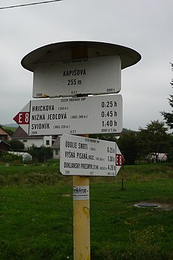
 Signposts in Kapišová |
|
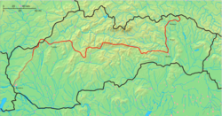
| map | |

|
|
| Data | |
| length | 769 km |
| location | Slovakia, Czech Republic |
| Supervised by | Club slovenských turistov (KST) |
| Markers |

|
| Starting point |
Devín Castle , Bratislava , Slovakia 48 ° 10 ′ 30.2 ″ N , 16 ° 58 ′ 42.9 ″ E |
| Target point |
Duklapass near Vyšný Komárnik , Slovakia 49 ° 25 ′ 3.1 ″ N , 21 ° 41 ′ 43.8 ″ E |
| Type | Long-distance hiking trail |
| Height difference | 1850 m |
| The highest point | Branch below the Chopok ( 1995 m nm ) |
| Lowest point | Devín Castle ( 145 m nm ) |
The Cesta hrdinov SNP ( German Path of the Heroes of the Slovak National Uprising ; also just Path of the Heroes ) is the most important long-distance hiking trail in Slovakia . It stretches through the whole of Slovakia from Devín Castle at the confluence of the March into the Danube near Bratislava to the Duklapass on the Polish-Slovakian border near Vyšný Komárnik . The route passes through Czech territory over a length of 26 kilometers . The route connects many places connected with the Slovak National Uprising or the liberation of Slovakia in 1944 and 1945.
The slovenských turistov club puts the total length of the trail at 769 kilometers. In other publications, the length can vary between 750 and 770 kilometers. The whole way is marked with a red marking. On average, it takes three to four weeks to cover the whole way.
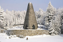
The path is almost completely identical to the Slovak section of the European long-distance hiking trail E8 and is identical to the Štefánikova magistrála from the Biely kríž junction near Svätý Jur to the tomb of Milan Rastislav Štefánik on Bradlo Mountain near Brezová pod Bradlom .
Route
The Cesta hrdinov SNP has a diverse landscape, some sections lead through basins and inhabited areas, but mostly it runs through mountains and over mountain ridges. After starting in Devín and through Devínska Kobyla , Slavín and Kamzík , the path leads along the main ridge of the Little Carpathians before reaching Bradlo with the tomb of Milan Rastislav Štefánik near Brezová pod Bradlom . The path to the White Carpathians comes through the hamlet area around Myjava . Between the Veľká Javorina mountain and the Kykula saddle , the path passes through Czech territory before crossing the Váh in Trenčín . At Trenčianske Teplice the route goes up the Strážovské vrchy , passes Horná Poruba and Čičmany , among others, to the Fačkov saddle on the edge of the Little Fatra .
The route bypasses the historic Turz (Slovak Turiec ) through the main ridge of the Žiargebirges before north of Handlová the Kremnica Hills reached. Behind Kremnica , the route first passes the Malý Šturec saddle and changes to the Great Fatra , then leads over the Veľký Šturec saddle and the Zvolen mountain near Donovaly . From there begins the almost 100-kilometer section on the main ridge of the Low Tatras , in the course of which Chopok , the highest point of the route, as well as the Čertovica saddle and the Kráľova hoľa mountain on the eastern edge of the Low Tatras are reached.
At the Besník saddle east of Telgárt the route reaches the Slovak Ore Mountains (Slovenské rudohorie) and follows the main ridge of the Volovské vrchy to the outskirts of Košice on the Jahodná mountain . There the path turns north, and over the small mountain range Čierna hora it soon reaches the populated mountainous Šarišská vrchovina , passes the outskirts of Prešov and climbs behind Veľký Šariš into the Čergov mountains. The last section through the Ondavská vrchovina mountains in the Low Beskids passes the town of Bardejov , over the Čierna hora mountain it reaches Svidník before arriving via Kapišová and Medvedie at the Duklapass , which forms the end of the route.
literature
- Jörn & Petra Kaufhold: Slovakia: Path of Heroes (E 8) . 1st edition. Conrad Stein Verlag, Welver 2016, ISBN 978-3-86686-388-0 , p. 160 (detailed route description, sights, overnight accommodation).
- Milan Lackovič, Juraj Tevec: Z Devína na Duklu . 1st edition. Dajama, Bratislava 2016, ISBN 978-80-8136-063-3 , p. 184 (Slovak, detailed description of the route, sights, places to stay. Note: the book describes the entire route, but does not specify the beginning of the Cesta hrdinov SNP until the Bradlo mountain).
Individual evidence
- ↑ notebook of the club slovenských turistov with basic information, profile, sections (Slovak), accessed on February 23, 2020


