
Chavanges
| Chavanges | ||
|---|---|---|

|
|
|
| region | Grand Est | |
| Department | Aube | |
| Arrondissement | Bar-sur-Aube | |
| Canton | Brienne-le-Château | |
| Community association | Lacs de Champagne | |
| Coordinates | 48 ° 31 ' N , 4 ° 34' E | |
| height | 114-182 m | |
| surface | 29.79 km 2 | |
| Residents | 591 (January 1, 2017) | |
| Population density | 20 inhabitants / km 2 | |
| Post Code | 10330 | |
| INSEE code | 10094 | |
| Website | http://chavangesofficiel.fr/ | |

Chavanges is a French commune with 591 inhabitants (as of January 1, 2017) in the Aube department in the Grand Est region ; it belongs to the arrondissement of Bar-sur-Aube and the canton of Brienne-le-Château (until 2015: canton of Chavanges ).
geography
The municipality is located in the Champagne sèche region , around 35 kilometers north-east of Troyes . Chavagnes is surrounded by the neighboring communities of Margerie-Hancourt in the north, Arrembécourt in the northeast, Joncreuil in the east and northeast, Lentilles in the east and southeast, Villeret and Montmorency-Beaufort in the south, Courcelles-sur-Voire in the south and southwest and Pars-lès- Chavanges to the west.
Population development
| year | 1962 | 1968 | 1975 | 1982 | 1990 | 1999 | 2006 | 2013 |
| Residents | 672 | 818 | 721 | 695 | 728 | 689 | 667 | 597 |
| Source: Cassini and INSEE | ||||||||
Attractions
- Saint-Georges church from the 12th century, monument historique since 1907, the wooden glass windows are designed after the Apocalypse by Dürer
- Saint-Gengoul church in Chasséricourt, a historic monument since 1988
- Half-timbered houses
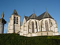
Saint-Georges church

Saint-Gengoul church


Personalities
- Gisèle Bienne (* 1946), writer
Web links
Commons : Chavanges - collection of images, videos and audio files