
Juvancourt
| Juvancourt | ||
|---|---|---|
|
||
| region | Grand Est | |
| Department | Aube | |
| Arrondissement | Bar-sur-Aube | |
| Canton | Bar-sur-Aube | |
| Community association | Region of Bar-sur-Aube | |
| Coordinates | 48 ° 7 ' N , 4 ° 48' E | |
| height | 195-357 m | |
| surface | 8.29 km 2 | |
| Residents | 122 (January 1, 2017) | |
| Population density | 15 inhabitants / km 2 | |
| Post Code | 10310 | |
| INSEE code | 10182 | |
.JPG) View of Juvancourt |
||

Juvancourt is a French commune with 122 inhabitants (as of January 1, 2017) in the Aube department in the Grand Est region (until 2015 Champagne-Ardenne ). The municipality belongs to the Arrondissement of Bar-sur-Aube and to the municipal association Région de Bar-sur-Aube, founded in 1993 . The residents call themselves Juvancourtois .
geography
The municipality of Juvancourt is located on the right bank of the Aube , about 60 kilometers east-southeast of Troyes and 30 kilometers west of Chaumont . The 8.29 km² municipal area is divided into two parts: in the west the approx. 300 m wide floodplain of the Aube, in the middle and in the east a densely wooded high plateau ( Bois de Medu ), which is up to 150 meters above the Aubetal. In the extreme south-east of the municipality, the highest point is reached at 357 m above sea level. To the east and south, Juvancourt borders the Haute-Marne department .
Juvancourt is surrounded by the neighboring communities of Longchamp-sur-Aujon in the north, Maranville in the northeast, Laferté-sur-Aube in the south and Ville-sous-la-Ferté in the west.
Place name
According to the dictionary of place names of France Larousse , the name Juvancourt comes from the Latin Juvinius cortem , which can be translated as Domain de Juvinius . The place name first appeared in 1115 as Juvencourt in a file from the Ckairvaux monastery. It was about a legal dispute between the monks and Charles de Coligny , lord of Andelot , Dinteville and Juvancourt. Over time, the spelling of the place name changed as follows:
- 1135 Juvencort
- 1147 Jovencort
- 1196 Juveincur and Juveincurt
- 1222 Juvancourt, Juvencourt, Jovencort and Giuvancort
- 1230 Givencuria
- 1237 Juvencuria
- 1250 Givancort
- 1581 Juvancuria
- 1674 Juvancour
From 1705 the spelling Juvancourt prevailed.
Population development
| year | 1962 | 1968 | 1975 | 1982 | 1990 | 1999 | 2007 | 2016 | |
| Residents | 153 | 151 | 167 | 153 | 165 | 148 | 163 | 121 | |
| Sources: Cassini and INSEE | |||||||||
Attractions
- Saint-Antoine church
- former wash house ( Lavoir )
- Croix Modot , one of the hallway crosses
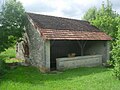
former wash house
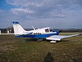
Airplane at the Juvancourt airfield
.JPG)

Economy and Infrastructure
There are two farms in Juvancourt that grow grain.
The Juvancourt airfield ( Aérodrome de Juvancourt , also Aérodrome de Bar-sur-Aube-Juvancourt ) is located on a cleared island east of the village of Juvancourt . It has a grass runway 900 m long and 50 m wide, which was laid out in the west-south-west-east-north-east direction. The runway runs over the 349 m high hill of Mont Perton . The airfield is used for aviation and tourism activities and has the ICAO code LFQX.
To the south, the A 5 autoroute ( Paris - Langres ) touches the municipality of Juvancourt; there is a junction in the neighboring municipality of Ville-sous-la-Ferté . One kilometer west of Juvancourt, the D 396 trunk road, which follows the Aubetal, runs from Bar-sur-Aube to Montigny-sur-Aube . The nearest train station on the Paris – Mulhouse line is in the town of Bar-sur-Aube, 16 kilometers away .
supporting documents
- ^ Dossier on the history of the parish in Juvancourt Town Hall
- ↑ Juvancourt on cassini.ehess.fr
- ↑ Juvancourt on insee.fr
- ↑ Farmers on annuaire-mairie.fr (French)