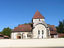
Donnement
| Donnement | ||
|---|---|---|
|
|
||
| region | Grand Est | |
| Department | Aube | |
| Arrondissement | Bar-sur-Aube | |
| Canton | Brienne-le-Château | |
| Community association | Lacs de Champagne | |
| Coordinates | 48 ° 31 ' N , 4 ° 26' E | |
| height | 112-182 m | |
| surface | 11.24 km 2 | |
| Residents | 77 (January 1, 2017) | |
| Population density | 7 inhabitants / km 2 | |
| Post Code | 10330 | |
| INSEE code | 10128 | |
Donnement is a French commune with 77 inhabitants (as of January 1, 2017) in the Aube department in the Grand Est region ; it belongs to the arrondissement of Bar-sur-Aube and the canton of Brienne-le-Château .
geography
The municipality is located in the Champagne sèche region , around 35 kilometers north-east of Troyes . Neighboring communities are:
- Balignicourt in the east,
- Braux in the southeast,
- Aulnay in the southwest,
- Jasseins in the west and
- Dampierre in the northwest.
The municipality is drained to the west by the Meldançon River , a tributary of the Aube .
traffic
Donnement is at the intersection of Département roads 24 and 56. It is a stage stop on the Via Francigena pilgrimage route .
Population development
| year | 1962 | 1968 | 1975 | 1982 | 1990 | 1999 | 2006 | 2014 |
|---|---|---|---|---|---|---|---|---|
| Residents | 194 | 194 | 165 | 128 | 101 | 111 | 96 | 80 |
Attractions
- Saint-Amand church, built from the 12th century ( Monument historique )
Web links
Commons : Donnement - collection of images, videos, and audio files

