
Lime
|
district of the state capital Düsseldorf |
|||
|---|---|---|---|
|
|||
| Basic data | |||
| Geographic location : | 51 ° 18 ′ N , 6 ° 46 ′ E | ||
| Surface: | 7.51 km² | ||
| Residents: | 1,983 (December 31, 2016) | ||
| Population density : | 264 inhabitants per km² | ||
| Incorporation : | 1st January 1975 | ||
| District: | District 5 | ||
| District number: | 056 | ||
| Transport links | |||
| Bundesstrasse : |
|
||
| Bus route: | 728 749 751 760 | ||


The Düsseldorf district of Kalkum , which was officially written as Calcum until 1930 , is one of the oldest places in the city of Düsseldorf. It belongs to the Düsseldorf district 5 . The local dialect speaks of Kalkem .
location
Except for the east, in which the city of Ratingen is located, Kalkum is surrounded by other districts of Düsseldorf . These are Wittlaer in the northwest , Angermund in the north , Lohausen in the south and Kaiserswerth in the west .
history
A royal court in Calechheim was first mentioned in a deed of donation from the East Franconian King Arnulf of Carinthia from 892, which was lost a long time ago . Despite the loss of the document, its text is known as it is quoted in a document from Emperor Otto the Great from the year 956. The earliest surviving documentary reference to Kalkum also comes from a document from Emperor Otto the Great, who in 947 confirmed the rights and possessions granted to Gandersheim Monastery by his predecessors. The text also mentions the possessions in villis Cruht et Kalecheim . Another early reference to Kalkum concerns the noble lords of Kalkum . A Willelmus de Calechheim can be proven for the year 1176. By the 14th century, the family's eponymous ancestral seat was expanded into a moated castle with a bailey . In the years 1398 to 1406 the lords of Kalkum were involved in the Kalkum feuds named after them with the city of Cologne, in which many Bergisch knights took part. After a first feud up to 1402, the second Kalkum feud from 1404 onwards led to a military conflict limited to the northern Duchy of Berg, in which the Archbishop of Cologne and Count Adolf VII von Berg were also involved. In this local war, the archbishop's mercenaries and the Cologne soldiers invaded the Bergische areas north of Cologne and covered them with robbery, pillage, destruction and murder. The Ratinger suburb was burned down, the former Arnols [von Kalkum] huyss ( House Remberg ) was completely destroyed, Burg Castle was conquered and Solingen was occupied.
In the middle of the 15th century, the moated castle in Kalkum with the associated lands came to the Lords of Winkelhausen through inheritance . The last of the male line from this noble family inherited the property through his daughter in 1703 to her husband from the noble Hatzfeld-Wildenburg family . The property in Kalkum remained in this family until it was sold in 1946 by Princess Marie von Hatzfeld-Wildenhorst to the State of North Rhine-Westphalia .
The St. Lambertus Church in Kalkum can be traced back to the year 1206 for the first time. The church was one of the early village churches that were built in the Decanat Neuss in the 11th or 12th century. In the northern area of County Berg these were small three-aisled and flat-roofed pillar basilica. At this early point in time, the church was under the authority of the Abbess von Gandersheim . This pen possessed further benefices in the Kalkum Honschaft. The Kalkumer Mühle, for example, initially belonged to the Gandersheim monastery. Later the Lords of Winkelhausen had the power of disposal over the mill. The parish of Kalkum included Angermund , Rahm and a northern part of Rath . The parish was relatively wealthy. In the tax revenue of 1308, the parish in the Neuss dean's office was in sixth place from 59.
Before the middle of the 14th century, the main course in Kreuzberg was directly responsible for Kalkum. Then Kalkum was attached to the Angermund district court. Like all regional courts in this northern area of the Grafschaft von Berg, this was subject to the main court in Kreuzberg.
With regard to the local income in Kalkum for day laborers and tenants of small and large farms in the areas north of Düsseldorf, information was contained in a directory from 1487. This stated the number of lenders for a forced loan for the Duke von Berg. Only tenants of larger farms are likely to have been able to raise the required loan of at least one or more gold guilders. With 9 to 14 people, Kalkum with Bockum (11 to 12) and Rath (14 to 22) were well ahead of the places: Einbrungen, Eller, Hubbelrath, Lohausen, Ludenberg, Vennhausen and Wittlar, for all of which only between 2 and 7 lenders were listed were.
Due to the local proximity to Kaiserswerth , the local area of Kalkum was inevitably also affected by armed conflicts over the city of Electorate of Cologne from 1424 with its imperial palace . In particular, the existing Kalkum moated castle with its grounds was used at times for the billeting of troops during these events. This was the case both in the Cologne War in 1586 and in the Thirty Years' War in 1636. In the armed conflicts of the Cologne diocese dispute and the War of the Spanish Succession in 1688/89 and 1702, further damage was caused by soldiers passing through and billeted in Kalkum Castle. The damage to the buildings was not extensive, but the corridor near Kalkum in particular was severely devastated during this event by excavation work . Also in the Seven Years' War 1756/63 billeting took place again by the troops of the states involved in the conflict.
During the French rule in the Rhineland from 1806, Kalkum in the Grand Duchy of Berg belonged to the Department of Düsseldorf and the Canton of Ratingen. After the Prussians took over rule in the Rhineland from mid-1814, Kalkum was a church village in the Düsseldorf district and was subordinate to the mayor's office in Kaiserswerth. Around 1817 there were 1,115 people living in the Kalkum parish, all of whom, with one exception, were Catholic. In addition to the village of Kalkum with 474 residents, the parish also included the villages of Lohausen and Zeppenheim. In addition to the manor and Kalkum Castle, there were several larger individual farms outside the village area. Some of these farms were back then: An den Dörnern, Forsthof and Heiderhof. For 1836, without the residents of the castle, 471 residents and 112 houses were given for the parish village of Kalkum. At that time, Zeppenheim and Calcum, like the villages of Lohausen and Stockum, formed a special community. In 1845 the Kalkumer Schlossallee, planned as an extension of the Kaiserswerther-Ratinger-Chaussee, was completed. The stagecoaches between Ratingen and Kaiserswerth stopped in front of the house of the tenant and master brewer Peter Küpper, built in 1827. The barrier station for road money was also a restaurant, which was run from 1895 by the host Bernhard Freemann, who came from Warendorf, and is known by this name to this day.
In 1929 Kalkum was assigned to the new administrative unit Amt Ratingen Land , but had to cede an area of 0.91 km² with 1112 inhabitants to Düsseldorf. In 1930 Kalkum lost its administrative autonomy and by decree of the Prussian Ministry of the Interior the merging of the spots and places Bockum , Wittlaer , Kalkum with Zeppenheim, Einbrungen , and Froschenteich to form the new rural community Wittlaer. In the course of the next administrative reorganization, this large community of Wittlaer was added to the state capital Düsseldorf on January 1, 1975. The city of Düsseldorf granted Kalkum with Zeppenheim the status of a separate Düsseldorf district within the city district 05, changing the demarcation.
In terms of area, it is one of the larger districts with 7.62 km², but in terms of population with 1,890 it is one of the smaller districts. It is located in the north of Düsseldorf, surrounded by numerous forests and fields. The high recreational value as well as the proximity to the historical center of Kaiserswerth make Kalkum a popular residential area. The large proportion of green areas, quarry ponds and forest are under landscape protection and should not be released for building for the time being. Single-family houses with a high standard of living predominate. Depending on the direction of the wind, however, the noise from Düsseldorf Airport, which is adjacent to the south, and the heavy through traffic can lessen the peaceful impression.
Kalkum is one of the richest districts in Düsseldorf. The average annual income here is 71,766 euros (as of December 31, 2007).
The Kalkum moated castle makes Kalkum an attractive destination for cyclists from the area. The castle used to be the headquarters of the Hatzfeld family and was sold to the state of North Rhine-Westphalia in 1946 , which had set up a branch of the main state archive in Düsseldorf there in 1962 . The landscaped garden that surrounds the castle is part of the green lung of the district.
Also worth seeing are those in the 12./13. The parish church of St. Lambertus from the 19th century and the old watermill on the Schwarzbach .
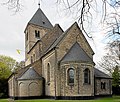
St. Lambertus in Kalkum
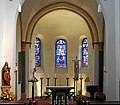
Look into the choir

Kalkum Castle


traffic
In 1846 the Cologne-Mindener Eisenbahn-Gesellschaft opened the Düsseldorf to Duisburg section. Kalkum was connected to this route via its own train station. This Kalkum station on the Cologne – Duisburg railway line was closed with the opening of the Düsseldorf Airport station just 1.5 km away ; Remnants of the covered platform can still be clearly seen when driving through. The trains of the S-Bahn line 1 stopped here for the last time before May 27, 1990 . On the metro line 79 to Kalkum reached via the stop Kalkumer Schlossallee . Branching off the federal road 8 , Kalkum is accessed by the state road L 422.
Sons and daughters
- Johann Peter von Langer (1756–1824), German painter
- Wilhelm Schmitz (1828–1898), German philologist and grammar school director
literature
- Peter Henkel: The Düsseldorf subcamps. Droste Verlag, 2016. 64 pages. ISBN 978-3770060108
Web links
Individual evidence
- ^ Office for statistics and elections of the state capital Düsseldorf: Statistics for the district 056 - Kalkum
- ^ RBD Elberfeld, directory of changes in station names
- ^ MGH DD Arn 107a.
- ^ MGH DD O I. 180.
- ^ MGH DD O I. 89.
- ↑ LAC I 453
- ^ Annals of the historical association for the Lower Rhine . In: Section: Reports and Notes . 1901, Issue 27, p. [142] 132. Online version
- ↑ a b Wisplinghoff, Erich. In: Düsseldorf history from the origins to the 20th century . In: The rural environment: I. On the right bank of the Rhine . 1990, 2nd edition, Schwann 1988 Patmos Verlag, editor: Hugo Weidenhaupt, p. 396. ISBN 3-491-34221-X
- ↑ Wisplinghoff, Erich. In: Düsseldorf history from the origins to the 20th century . In: The rural environment: I. On the right bank of the Rhine . 1990, 2nd edition, Schwann 1988 Patmos Verlag, editor: Hugo Weidenhaupt, p. 395. ISBN 3-491-34221-X
- ↑ Wisplinghoff, Erich. In: Düsseldorf history from the origins to the 20th century . In: The rural environment: I. On the right bank of the Rhine . 1990, 2nd edition, Schwann 1988 Patmos Verlag, editor: Hugo Weidenhaupt, p. 393. ISBN 3-491-34221-X
- ↑ steel. In: Description of the administrative district of Düsseldorf . 1817, Düsseldorf, p. [15] 7. Online version
- ^ Viebahn, Johann Georg von. In: Statistics and topography of the government district of Düsseldorf. Second part . 1836, Düsseldorf, p. 76.
- ↑ Statistical Yearbook Düsseldorf 2012 (PDF; 8.3 MB).
Remarks
- ↑ So far it has been assumed that the man named Arnols huyss in the Koelhoff chronicle meant the moated castle in Kalkum, the predecessor of today 's Kalkum Castle . According to recent investigations, the burned down house is not the Kalkum Castle, but the Remberg house in Duisburg - Huckingen . Source: Dietmar Ahlemann: Haus Remberg , in: Bürgererverein Duisburg-Huckingen eV (Ed.), Huckinger Heimatbuch (Volume III), Duisburg 2015, pp. 175–196.
| District 1 |
Old town | Carlstadt | Derendorf | Golzheim | Pempelfort | City center |
|
| District 2 | ||
| District 3 |
Bilk | Supplication | Friedrichstadt | Port | Hamm | Oberbilk | Unterbilk | Volmerswerth |
|
| District 4 |
Heerdt | Loerick | Niederkassel | Oberkassel |
|
| District 5 |
Angermund | Kaiserswerth | Calcum | Lohausen | Stockum | Wittlaer |
|
| District 6 | ||
| District 7 |
Gerresheim | Grafenberg | Hubbelrath | Knittkuhl | Ludenberg |
|
| District 8 |
Eller | Lierenfeld | Unterbach | Vennhausen |
|
| District 9 |
Benrath | Hassels | Heavenly Spirit | Holthausen | Itter | Rice wood | Urdenbach | Wersten |
|
| District 10 |