
Daugava
|
Daugava Latvian Daugava Russian Западная Двина ( Zapadnaya Dvina , Western Dvina ) |
||||||||
| location |
|
|||||||
| River system | Daugava | |||||||
| Headwaters |
|
|||||||
| Source height | 221 m above sea level Baltic Sea | |||||||
| muzzle |
|
|||||||
| length | 1020 km | |||||||
| Catchment area | 87,900 km² | |||||||
| Reservoirs flowed through |
|
|||||||
| Big cities |
|
|||||||
| Medium-sized cities |
|
|||||||
 The catchment area of the Daugava |
||||||||
|
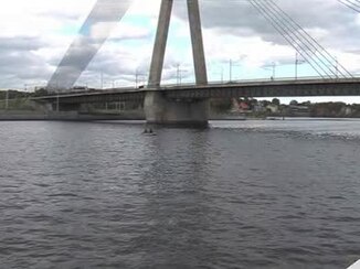
The Düna (Daugava) near Riga (2010) |
||||||||
The Düna ( Latvian Daugava , polish Dźwina , belarusian Дзвіна Dswina , Russian Западная Двина Sapadnaja Dwina ) is in the Baltic Sea opening out, 1020 km long stream .
The Russian name Sapadnaya Dvina literally means "Western Dvina" to distinguish it from the Northern Dvina .
course
The river begins in Russia on the Valdai Heights south of Bobrovets, Andreapolski Rajon, Tver Oblast near the Volga springs .
The Little Daugava ( Russian Двинец Dwinez ) flows at Schtschewerewo ( Russian Щеверево ) from the Korjakino Lake ( Russian Озеро Корякино Ozero Korjakino ) about four kilometers to the Ochwato chain of lakes ( Russian Озеро Охват Ozero Ochwat ). The flow through the lakes for about 20 km is already regarded as the Western Daugava ( Russian Западная Двина Sapadnaja Dvina ). At the confluence with the saddle Berka ( Russian река Жаберка Reka Saddle Berka ) of the actual course of the river begins Daugava .
It flows first to the southwest. At Orljaki ( Russian Орляки ) is the middle of the river for two kilometers border with Belarus and is now called Dswina ( Belarusian Дзвіна ). After Vitsyebsk ( Belarusian Віцебск ) it continues along the Belarusian ridge in a westerly direction through northern Belarus continued.
In addition to Ula ( Belarusian Ула ), the Berezina canal system ( Belarusian Бярэзінская водная сістэма Bjaresinskaja vodnaja sistema , Russian Березинская воднская водная системna Beresinskaya ) branches south from Beresinskaya . It used to be a connection to the Dnieper and thus part of the connection from the Baltic Sea to the Black Sea .
In Patarnieki will Daugava for 17 kms to the border river and continues to flow through Latgale , the south-eastern region of Latvia , by Daugavpils (German Daugavpils ) and then to the northwest Gulf of Riga , where the Riga district Daugavgrīva (German Dünamünde ) in the Baltic Sea opens .
The total length is between 1,005 and 1,020 km, depending on the type of calculation. The length on Latvian territory is 357 km, in Belarus 335 km.
Tributaries
Note: Sorting takes place downstream.
Word origin
The river emerges as Dina, Tina Tuna, Veina or Dyna first in Viking sagas and Nestorchronik on. The Liv designation is Veina or Ven . Dvna , a Latinized form of the German name Düna , was used in handwritten medieval documents and can still be found on maps from the 17th century.
The Latvian and Lithuanian name Daugava was traced back by philologists ( August Bielenstein , Ernest Blese , Jānis Endzelīns and others) to the root word “daudz” and “ūdens” and originally meant something like “big water” or “strong river”. According to the philologist Konstantins Karulis, the root word Dyna was originally used in the Latvian language . It was gradually replaced by its current name between the 14th and 17th centuries.
In the Latvian Dainas , the river is sung about as “Mother Daugava ” ( Latvian Daugaviņa māmuliņa ) and as the “ River of Fate”.
history

The Düna was since the fourth millennium BC. Settlement area of Indo-European immigrants, from which East Baltic tribes formed in the course of time.
In the first century AD, a river called Rhubon ( ancient Greek Ῥούβωνος Rhubonos or Rhudon ) is mentioned in the ancient script Geographike Hyphegesis by Claudius Ptolemy , which means the Daugava or the Memel .
The river has been an important trade route since ancient times, allowing easy access to the river systems of the Volga and Dnieper .
Since the eighth century at the latest, the Daugava was one of the routes of the Varangians ( Vikings ) on the " route from the Varangians to the Greeks " to the Black Sea . Important castles included Grobin , Polatsk and Vitebsk .
Since the ninth century, the Baltic tribes of the Semgalli , Latgale and Selonians have been known on the Daugava Krivich around Polotsk, and since the 13th century , from which the Latvians developed in the following centuries .
In the Middle Ages, due to the low river bed and the many rapids near Dünamünde, the larger ships loaded the goods onto rafts or strusses for travel on the river.
With the Union of Vilnius in 1561, the river became a political and cultural border.
In the 16th century, the river bed in the estuary also changed. The old drain, the Vecdaugava , then silted up.

In July 1701, as part of the Great Northern War, the Battle of the Daugava took place in Krämershof (in Latvian Krēmera muiža ) north of Rīga (now in the urban area).
Since 1913, the "Riga-Cherson Canal Commission", a union of Rigans merchants and industrialists, planned a canal between Vitebsk on the Daugava and Orsha on the Dnieper, which was to connect both rivers and so Riga with the port city of Cherson on the Black Sea . Six barrages, each with a hydroelectric power plant, were planned on the Daugava. a. at Pļaviņas (German Stockmannshof ), at Ķegums (German Keggum ) and at Doles sala (German Dahlen ) / Salaspils (German Kirchholm ). As a result of the First World War , through which the Russian Empire disintegrated and Latvia became independent, the project of building canals and hydroelectric power stations fell apart.
traffic


In the Russian section, the Daugava can only be used for boat traffic. If the water level is sufficient, it is navigable from Belarus up to CEMT I , from Jekabpils also up to CEMT III. In the estuary area, sea traffic is possible from the Vanšu Bridge in Riga. Due to some barriers, continuous shipping is no longer possible.
In the 19th century there was a connection between the Baltic Sea and Düna, via the tributary Ula , the Berezina canal system to the Dnieper and into the Black Sea . The waterway lost its importance due to the expansion of rail and road connections. The hydraulic engineering systems fell into disrepair. This route is only partially passable for excursion and pleasure boat traffic.
The nature park “Daugavas Loki” (Daugava Arches) between Kraslava and Krauja is very popular with water sports enthusiasts.
Reservoirs and hydropower plants
What the young Republic of Latvia realized from the plans of the "Riga-Cherson Canal Commission" was the construction of the reservoir and the hydroelectric power station at Ķegums ( Ķeguma hidroelektrostacija , mostly abbreviated: Ķeguma HES ) from 1936 to 1940. The second reservoir with hydroelectric power station was for Soviet period - despite violent protests from the Latvian population - built from 1959 to 1968 near Pļaviņas ( Pļaviņu hidroelektrostacija , mostly abbreviated: Pļaviņu HES ). The third Latvian reservoir with hydropower plant at Salaspils near Riga ( Rīgas hidroelektrostacija , mostly abbreviated: Rīgas HES ) was completed in 1974.
The protests by nature conservationists against a fourth dam planned in the 1980s near Daugavpils mark the beginning of a national movement that led to the restoration of Latvia's independence in 1990/91.
On June 30, 2017, a hydropower plant and a lock about eight kilometers upstream from Vitebsk ( Belarusian Витебская ГЭС Vitebskaja GES ) went into operation. The four turbines have a total output of 40 MW , the planned annual electricity generation is given as 138 million kWh. The energy generated is transferred to the 110 kV network.
Web links
Individual evidence
- ↑ a b Article Düna in the Great Soviet Encyclopedia (BSE) , 3rd edition 1969–1978 (Russian)
- ↑ Edgars Dunsdorfs: Lielvidzemes KARTES (17 un 18 gadsimteni). Karla Zarina Fund, Melbourne 1986, ISBN 0-9595891-6-3 .
- ↑ Konstantins Karulis: Daugavas un Piedaugavas vietvārdi. Nosaukumu cilme. In: Latvijas Kultūras Fonds (ed.): Daugavas raksti. Volume 1: No Aizkraukles līdz Rīgai. Zinātne, Rīga 1991, ISBN 5-7966-0728-6 , pp. 148–156, here pp. 150–151.
- ↑ see: www.lab.lv/dok/Daugava_info.pdf
- ^ William Smith : Dictionary of Greek and Roman Geography. London 1854
- ↑ Gottlieb August Wimmer : History of the geographical voyages of discovery on water and on land. Vol. 1, Vienna 1838.
- ^ Alexander Stellmacher: The projected Riga-Cherson Canal . In: Baltic weekly for agriculture, industry and trade , vol. 52 (1914), no. 5 from 16 January jul. / January 29, 1914 greg. , Pp. 41-43.
- ↑ CEMT - European Inland Water Map of the UNECE
- ↑ Березинская водная система
- ↑ Water tourism in Latvia
- ↑ Nature Park “Daugavas Loki”
- ↑ Upper Daugava spillway valley and associated gully network at Vasargelišķi
- ↑ The construction of the Vitebsk hydropower plant, the most powerful in the country, has been completed (Russian)