
Flores (Azores)
| Flores | |
|---|---|
 |
|
| Waters | Atlantic Ocean |
| Archipelago | Azores |
| Geographical location | 39 ° 26 ′ N , 31 ° 13 ′ W |
 |
|
| length | 17 km |
| width | 12 km |
| surface | 143.1 km² |
| Highest elevation |
Morro Alto 914 m |
| Residents | 3692 (2016) 26 inhabitants / km² |
| main place | Santa Cruz das Flores |
Flores (German: flowers; Portuguese name: Ilha das Flores ) is the fourth smallest island of the Portuguese archipelago of the Azores in the Atlantic at 143.1 km² . The capital is Santa Cruz das Flores with about 1600 inhabitants.
About 3800 people live on the island. The official and colloquial language is Portuguese , but many residents also speak English or French .
In 2009, UNESCO added the island to the list of biosphere reserves .
geography

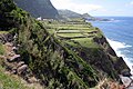
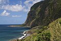
Flores measures 17 km in length and approximately 12.5 km at its widest point. The highest point is the extinct volcano Morro Alto with 914 m. The last volcanic activity was around 3000 years ago. Large parts of the island around Morro Alto are nature reserves .
Like the neighboring island of Corvo , in contrast to the other Azores islands, Flores lies on the North American plate . It is the westernmost European island, making Fajã Grande the westernmost village in Europe . The straight line distance to mainland Portugal is 1,863 kilometers and to Ponta Delgada about 520 kilometers.
history
Previous names of Flores were São Tomás and Santa Maria . The island was named after its unique floral landscape . In 1452 Diogo de Teive discovered the islands of Flores and Corvo , and the island was first settled around 1470 by the Flemish Wilhelm van der Haegen . However, he left Flores a few years later because the island was too isolated and there were no regular boat connections to Europe that could have ensured the export of the valuable dye plant woad (pastel).

Around 1500 the first settlers from Portugal followed, who founded the villages of Lajes das Flores and Santa Cruz das Flores . They cleared the island and planted grain , maize and vegetables . In the next centuries the inhabitants lived largely isolated; Due to the remote location, merchant ships rarely came from the Azores islands of Faial and Terceira to exchange whale oil , butter and honey for fabrics . Despite the isolation, Flores was often pillaged by pirates .
A turning point came in the mid-19th century when American whalers hunted sperm whales in the waters of the Azores . Many Flores residents hired the whalers. The American whaling ship Wanderer hunted whales until 1924.
In 1963 the French set up a telecommunications station on Flores. A hospital, a power station and an airport were built in the following years and brought financial growth to the island. The development of tourism has been accelerated since the French withdrew in 1994 .
administration
The island of Flores belongs to the autonomous region of the Azores and is therefore part of the national territory of Portugal .
.jpg)
The island is divided into two concelhos ( Portuguese districts):
-
Santa Cruz das Flores (capital), with four parishes:
- Caveira
- Cedros
- Ponta Delgada
- Santa Cruz das Flores
- Lajes das Flores , with seven parishes:
Web links
- The portal of the Azores. Information about the nine islands
- Information sites and photo tours Azores
- Flores in the Global Volcanism Program of the Smithsonian Institution (English)
- Homepage of the Serviço Regional de Estatística dos Açores (SREA) (engl./port.)
Individual evidence
- ↑ List of all UNESCO biosphere reserves on the homepage of the German UNESCO Commission , accessed on July 25, 2018.

Lagoa Comprida on the plateau
Ponta
Fajã de Lopo Vaz

Inland on the island of Flores


.jpg)
.jpg)


Main islands: Flores |
Corvo |
Faial |
Pico |
São Jorge |
Graciosa |
Terceira |
São Miguel |
Santa Maria
secondary islands: Formigas |
Fradinhos |
Ilhéu de Baixo |
Ilhéu da Baleia |
Ilhéus das Cabras |
Ilhéu das Lagoínhas |
Ilhéu de Maria Vaz |
Ilhéu de São Lourenço |
Ilhéu do Monchique |
Ilhéus dos Mosteiros |
Ilhéu da Praia |
Ilhéu de Vila Franca do Campo |
Ilhéu da Vila do Porto