
Freehold Township
| Freehold Township | |||
|---|---|---|---|
 Freehold Town Hall |
|||
| Location in New Jersey | |||
|
|||
| Basic data | |||
| Foundation : | October 31, 1693 | ||
| State : | United States | ||
| State : | New Jersey | ||
| County : | Monmouth County | ||
| Coordinates : | 40 ° 13 ′ N , 74 ° 18 ′ W | ||
| Time zone : | Eastern ( UTC − 5 / −4 ) | ||
| Residents : | 36,184 (as of 2010) | ||
| Population density : | 362.9 inhabitants per km 2 | ||
| Area : | 100.3 km 2 (approx. 39 mi 2 ) of which 99.72 km 2 (approx. 39 mi 2 ) are land |
||
| Height : | 36 m | ||
| Postal code : | 07728 | ||
| Area code : | +1 732 | ||
| FIPS : | 3402525230 | ||
| GNIS ID : | 0882116 | ||
| Website : | twp.freehold.nj.us | ||
| Mayor : | Barbara J. McMorrow ( R ) | ||
 Co-Cathedral of St. Robert Bellarmine |
|||

The Freehold Township is a township in Monmouth County in the US state of New Jersey . At the last census in 2010 , the Freehold Township had 36,184 inhabitants, making it the fourth largest administrative unit in Monmouth County. The Borough of Freehold , which is completely surrounded by the Freehold Township, is an independent city and not part of the Freehold Township.
geography
The Freehold Township is located in eastern New Jersey and southern Monmouth County. The Freehold Township is bordered clockwise to the north, starting with Marlboro Township , Colts Neck , Howell Township and Millstone Township in Monmouth County, Jackson Township in Ocean County and Manalapan Township , again in Monmouth County. In addition, the township borders on the city of Freehold, which it completely encloses. In the area of the Freehold Township are the census-designated places Blue Ball, Burlington Heights, East Freehold, Georgia, Orchard Estates, Siloam, Smithburg, Southburg, Stonehurst East, Stonehurst West and West Freehold.
history
The history of settlement in the area of the Freehold Township began with the settlement by the Native Americans from the Lenni Lenape tribe , who lived mainly from hunting and did not establish permanent settlements, but changed them from year to year. In 1498 a European came to the area for the first time with the Dutchman John Cabot and founded the first settlement. In 1685 Scottish settlers arrived in what is now Freehold Township and established the first permanent settlement, which was formed on October 31, 1693 together with the towns of Middletown and Shrewsbury within Monmouth County. The name Freehold comes from the English term for rural property.
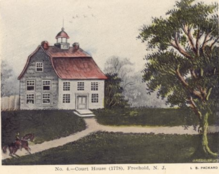
In 1714 the surveyor and then owner of the Freehold Township, John Reid, proposed the township as the seat of Monmouth County. For this he sold his land cheaply to the New Jersey Board of Chosen Freeholders and the Freehold Township ultimately prevailed against Middletown and Shrewsbury as a county seat . The Monmouth County Courthouse was built and completed in 1715, and the initially small village began to grow rapidly. Shortly after the completion of the courthouse, there were already several apartments, a village shop , a bank, a hotel, a saloon and a police station with a prison. The area around the Monmouth County Courthouse was mainly surrounded by farms, which were particularly known for their cultivation of potatoes, beans and rye. Around 1731, part of the Freehold Township became the Upper Freehold Township . In 1745, the majority of the inhabitants were of Scottish descent, which is still reflected in some street names today.
The Freehold Township was strongly shaped by the events of the American Revolution . From the early 1770s, the Sons of Liberty began recruiting residents of the Freehold Township. After the Battle of Long Island , won by the British , the Freehold Township fell under the control of the Loyalists and some members of the Sons of Liberty were arrested for their activities. Only the victory of the Continental Army in the Battle of Trenton was able to weaken the control of the loyalists over the Freehold Township again. On June 28, 1778, the Battle of Monmouth began in Freehold , one of the largest fights during the American Revolution with about 25,000 soldiers in the various armies. In the end, both the Continental Army under George Washington and the British Armed Forces under Henry Clinton declared victory after the Continental Army was able to fend off the British, but the British in return were able to claim the city of Philadelphia for themselves. After the Battle of Monmouth, the control of the Loyalists finally wavered until they finally gave it up in 1780 after further minor battles.
In the first census ever conducted in the United States in 1790, the Freehold Township had 3,785 residents and has continued to grow since then. The village of Monmouth Courthouse has been renamed Freehold. Freehold later lost a large part of its area, first with the establishment of Millstone Township on February 28, 1844 and later with the establishment of Jackson Township (March 6, 1844), Colt Neck Township (February 18, 1847), and Marlboro Township (February 17, 1848) and finally with the establishment of the Manalapan Township on March 9, 1848. In 1852 a stop was set up with the beginning of the construction of a railway line, and soon afterwards more modern sewers were built. On October 30, 1873, almost the entire city was destroyed by a major fire. After the Freehold Township was connected to the telephone network in 1883, a short-term strong population growth was again noticeable. Freehold developed into an industrial and commercial center in New Jersey, which was positively influenced by its location near major cities such as Philadelphia and New York City .

From the beginning of the 20th century, increasing disparities developed between the center of Freehold and the surrounding farmland . After a public debate about the outsourcing of the city of Freehold from the township, a referendum took place in which the majority of the citizens voted for the outsourcing of the city of Freehold from the township. This spin-off and the resulting establishment of the Borough of Freehold was officially completed on April 15, 1919. In the Borough of Freehold, the administrative buildings of the Freehold Township were initially still located, and the Freehold Township also gave its status as a County Seat to the Borough of Freehold. A new town hall was later built in the Freehold Township. On November 7, 1926, the Freehold Township gave another part of the urban area to the Borough of Freehold. After the end of the Second World War , the Freehold Township experienced strong population growth. This was influenced by the expansion of the infrastructure, which enabled better connections to the major cities of New York City, Philadelphia and Newark and made commuting between the cities easier. There was also economic and industrial growth, and job opportunities were created primarily through the construction of production halls for Nestlé and 3M . In 1971 a large hospital complex, today's CentraState Medical Center, opened in Freehold Township. In 1990 the Freehold Raceway Mall , the second largest mall in New Jersey, opened.
Five residents of the Freehold Township were killed in the terrorist attacks on September 11, 2001 , for which the Freehold Township 911 Memorial next to the town hall was later inaugurated.
Demographics
| growth of population | |||
|---|---|---|---|
| Census | Residents | ± in% | |
| 1810 | 4784 | - | |
| 1820 | 5146 | 7.6% | |
| 1830 | 5481 | 6.5% | |
| 1840 | 6303 | 15% | |
| 1850 | 2642 | -58.1% | |
| 1860 | 3811 | 44.2% | |
| 1870 | 4231 | 11% | |
| 1880 | 1870 | -55.8% | |
| 1890 | 2165 | 15.8% | |
| 1900 | 2234 | 3.2% | |
| 1910 | 2329 | 4.3% | |
| 1920 | 1498 | -35.7% | |
| 1930 | 1720 | 14.8% | |
| 1940 | 2459 | 43% | |
| 1950 | 3442 | 40% | |
| 1960 | 4779 | 38.8% | |
| 1970 | 13,185 | 175.9% | |
| 1980 | 19.202 | 45.6% | |
| 1990 | 24,710 | 28.7% | |
| 2000 | 31,537 | 27.6% | |
| 2010 | 36,184 | 14.7% | |
| US Decennial Census | |||
2010 Census
At the 2010 census, the Freehold Township had 36,184 residents, spread over 12,577 households and 9382 families. Of the population, 30,509 (84.32%) were White , 1931 (5.34%) African American , 2,544 (7.03%) Asian , 47 (0.13%) Native American , 7 (0.02%) Pacific Islander , 531 (1.47%) residents of other races and 615 (1.7%) belonged to two or more of these groups. Hispanics and Latinos together made up 7.76% of the total population.
Of the 12,577 households, 36.7% had children under the age of 18 living with them and 61.4% were married couples. In terms of age, 24.3% of the residents were under 18 years old, 7.5% were between 18 and 24, 24.6% between 25 and 44, 30.7% between 45 and 64 and 13.0% were older than 65 years . The median age was 41.3 years.
The median income in the Freehold Township at the time of the census was $ 94,735 and the median income for a family was $ 112,094. The average per capita income was $ 40,504. 3.9% of the population lived below the poverty line, of these residents 4.6% were under 18 and 4.0% over 65 years old.
Census 2000
At the 2000 census , the Freehold Township had 31,537 residents, spread across 10,814 households and 8,283 families. 87.09% of the population were white, 5.15% Asian, 5.12% African American, 0.14% Native American, 1.21% other races, and 1.3% belonged to two or more groups. Hispanics and Latinos made up 5.19% of the total population.
Of the 10,814 households, 37.8% had children under the age of 18 living with them, 65.9% were married couples. In 2000, 25.3% of the township's residents were younger than 18 years, 6.1% were between 18 and 24, 31.2% between 25 and 44, 25.5% between 45 and 64 and 12.0% of the population Residents were older than 65 years. The median age was exactly 38 years.
Attractions
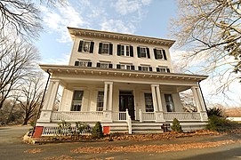
Two buildings in the Freehold Township are listed buildings and have been added to the National Register of Historic Places .
- The Monmouth Battlefield State Park is a little more than seven square kilometers large park on the border with Manalapan Township, on whose territory the Battle of Monmouth took place in 1778. The park was admitted in its entirety to the NRHP on October 15, 1966.
- The Walker-Combs-Hartshorne Farmstead was built in 1686 and expanded several times in the following time. In 1911 the house was bought by Charles Oakley, Jr. At that time, the main building and 23 other farm buildings on an area of around 35 hectares belonged to the farmland. After Oakley's death in 1932, his heirs continued to operate the farm until they sold the farm in 1972. In 1981 the Walker-Combs-Hartshorne Farmstead was the oldest operating farm in New Jersey. On October 4, 1990, the building was included in the NRHP.

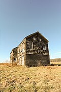
Monmouth Battlefield State Park
Cobb House in Monmouth Battlefield State Park
Sutfin House

General Von Steuben Memorial

Craig Farm House

Walker-Combs-Hartshorne Farmstead


Economy and Infrastructure
economy
In the Freehold Township is the Freehold Raceway Mall , which is the second largest shopping center in the state of New Jersey with 237 shops on an area of around 150,000 m².
traffic

US Highway 9 between Linwood and Newark and New Jersey State Route 33 between Heightstown and Asbury Park run through the Freehold Township area . Freeway connections exist via Heightstown to Interstate 95 between Philadelphia and New York City and via Howell to Interstate 195 .
From Freehold Township, New Jersey Transit buses run to New York City, Newark and Jersey City and between Lakewood Township and Old Bridge Township .
education

The Freehold Township Schools district has eight schools, five of which are elementary schools, two middle schools and one preschool. In the school year 2016/17, 3801 pupils up to the eighth grade were taught at the schools in the school district. There is also a high school in the Freehold Township with 2,111 students in the 2014/15 school year. Part of Brookdale Community College is within Freehold Township.
Personalities
- Katie Dippold (* 1980), screenwriter and actress
- Amanda Anisimova (* 2001), tennis player
Web links
Individual evidence
- ^ Freehold History. In: twp.freehold.nj.us. Freehold Township, accessed March 10, 2019 .
- ^ A b Barbara Pepe: Freehold: A Home Town History . Arcadia Publishing, Charleston, South Carolina 2003, ISBN 0-7385-2418-2 (English, google.de [accessed March 10, 2019]).
- ^ Michael S. Adelberg: The American Revolution in Monmouth County: The Theater of Spoil and Destruction . Arcadia Publishing, Charleston, South Carolina 2010, ISBN 1-61423-263-6 (English, google.de [accessed March 10, 2019]).
- ^ The Story of New Jersey's Civil Boundaries: 1606-1968. (PDF) Bureau of Geology and Topography, 1968, pp. 179f. , accessed on March 10, 2019 .
- ^ Census of Population and Housing. United States Census Bureau, accessed March 10, 2019
- ^ Profile of General Population and Housing Characteristics: 2010. In: factfinder.census.gov. United States Census Bureau, accessed March 10, 2019 .
- ↑ History of Walker Combs Hartshorne (Oakley) Farm. In: twp.freehold.nj.us. Freehold Township, accessed March 10, 2019 .
- ^ District information for Freehold Township School District. National Center for Education Statistics, accessed March 10, 2019 .