Riegelsberg
| coat of arms | Germany map | |
|---|---|---|

|
Coordinates: 49 ° 18 ' N , 6 ° 57' E |
|
| Basic data | ||
| State : | Saarland | |
| County : | Regional association Saarbrücken | |
| Height : | 337 m above sea level NHN | |
| Area : | 14.7 km 2 | |
| Residents: | 14,366 (Dec. 31, 2019) | |
| Population density : | 977 inhabitants per km 2 | |
| Postal code : | 66292 | |
| Area code : | 06806 | |
| License plate : | SB | |
| Community key : | 10 0 41 517 | |
| LOCODE : | DE RGB | |
| Community structure: | 2 parishes | |
| Address of the municipal administration: |
Saarbrücker Str. 31 66292 Riegelsberg |
|
| Website : | ||
| Mayor : | Klaus Häusle ( SPD ) | |
| Location of the municipality of Riegelsberg in the Saarbrücken regional association | ||

Riegelsberg is a municipality in the Saarland and is located north of the state capital Saarbrücken . It consists of the two municipal districts of Riegelsberg and Walpershofen .
geography
climate
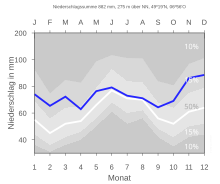
| The annual precipitation is 884 mm and is thus in the upper third of the values recorded by the measuring points of the German Weather Service . Over 76% indicate lower values. The driest month is April; it rains most in December. In the wettest month there is around 1.4 times more rain than in the driest month. The seasonal fluctuations in precipitation are in the lower third. In only 4% of all locations, the monthly precipitation fluctuates less. |
history
In 2009, the municipality of Riegelsberg was able to look back on its 70th anniversary as an independent unified municipality. The historical reference point is the amalgamation of the previously independent municipalities that came into force on April 1, 1939
- Guchenbach: at that time approx. 7200 inhabitants
- Hilschbach: at that time approx. 775 inhabitants
- Überhofen: at that time approx. 570 inhabitants
Riegelsberg community
The hill west of the main road from Saarbrücken via Lebach to Trier , on which the Hindenburg tower stands today , was called Riegelsberg . The name Riegelsberg was first mentioned as a field name in 1731. The first settlement probably already existed in 1764.
The Riegelsberg settlement originally formed part of the municipality of Güchenbach. Administratively, the community of Güchenbach belonged to the Sellerbach mayor, which was created in 1816 as part of the subdivision of the Saarbrücken district. In 1875, after the construction of the new town hall, Riegelsberg became the official seat of the Sellerbach mayor. The latter was renamed in 1936 after its administrative seat in the mayor's office (later office) Riegelsberg.
After the merger of the municipalities of Güchenbach, Hilschbach and Überhofen to form the municipality of Riegelsberg (in April 1939) and the voluntary departure of the municipality of Köllerbach from the administrative community (in April 1948), the mayor's office of Riegelsberg only included the municipalities of Riegelsberg and Walpershofen. Walpershofen is located in the middle of the Köllertal on both sides of the Köllerbach . The place, which probably originated in the first millennium AD, was first mentioned in a document in 1293. In the 16th century Walpershofen had 50 inhabitants.
For centuries agriculture was the main source of income for the population of the entire Köllertal.
Even the coal mining was once very common here. The beginnings of hard coal mining in the Köllertal can be traced back to the 15th century, but mining did not develop into an important economic factor until the middle of the 19th century through the development of the Prussian mining treasury. The decisive impetus for the population, settlement and economic development of the Riegelsberg area came from the Von der Heydt mine , which was put into operation in 1852. There were three shafts in the lamp nest , which were built in 1872, 1888 and 1891. The last shaft was closed in 1916. This mining past was commemorated in 2006 with a memorial for over 200,000 euros. This monument, 12 meters high, which contains a rope sheave , a goods cart and a service vehicle in three steel cubes , was discussed controversially among the population after it was built.
Through the law on the restructuring of the municipalities and districts of Saarland of January 19, 1973 , the previously independent municipalities of Riegelsberg and Walpershofen were merged on January 1, 1974 to form the new municipality of Riegelsberg. At the same time, parts of the area with then more than 400 inhabitants (with the Von der Heydt settlement ) were ceded to the state capital Saarbrücken.
Population development
| date | Residents |
|---|---|
| June 6, 1961 1 | 12,373 |
| May 27, 1970 2 | 14,068 |
| December 31, 2005 | 15,386 |
| March 31, 2006 | 15,357 |
| June 30, 2006 | 15,343 |
| September 30, 2006 | 15,309 |
| November 28, 2007 | 15,267 |
| December 31, 2010 | 14,943 |
| December 31, 2011 | 14,834 |
| December 31, 2012 | 14,630 |
| December 31, 2015 | 14,611 |
| December 31, 2018 | 14,501 |
Footnotes
1 1961: Riegelsberg within its current boundaries; 11,158 inhabitants (census results) within the limits at that time
2 1970: Riegelsberg within the current limits; 12,306 inhabitants within the limits at that time (census result)
politics
mayor
| Term of office | Surname | Political party |
|---|---|---|
| 1974-1981 | Walter Wagner | CDU |
| 1981-1991 | Norbert Holzer | CDU |
| 1991 - October 2009 | Lothar Ringle | SPD |
| since November 1, 2009 | Klaus Häusle | SPD |
In the local elections on June 7, 2009, Klaus Häusle (SPD) was elected mayor. In the local elections on May 26, 2019, Häusle achieved the largest share of the vote with 43.5%, but had to go to the runoff election against Benjamin Schmidt (CDU) on June 9, 2019. Häusle won re-election by just 29 votes and a share of 50.2% of the votes.
Municipal council
The local election on May 26, 2019 in Riegelsberg led to the following result for the composition of the local council (with a difference to the 2014 election):
| Political party | Share of votes | difference | Seats | difference |
|---|---|---|---|---|
| CDU | 36.5% | −3.9 | 13 | −1 |
| SPD | 30.9% | −3.1 | 10 | −2 |
| GREEN | 12.0% | +4.3 | 4th | +2 |
| LEFT | 9.9% | −4.0 | 3 | −1 |
| AfD | 6.0% | +6.0 | 2 | +2 |
| FDP | 4.8% | +0.8 | 1 | ± 0 |
Local councils
In the local elections in 2019, the local councils had the following results (with the differences compared to the 2014 election):
Riegelsberg
| Political party | Share of votes | difference | Seats | difference |
|---|---|---|---|---|
| CDU | 39.1% | −1.8 | 6 seats | −1 |
| SPD | 38.6% | −0.7 | 6 seats | ± 0 |
| LEFT | 14.8% | −0.4 | 2 seats | ± 0 |
| FDP | 7.6% | +2.9 | 1 seat | +1 |
(Source)
Walpershofen
| Political party | Share of votes | difference | Seats | difference |
|---|---|---|---|---|
| CDU | 51.8% | +1.0 | 6 seats | ± 0 |
| SPD | 35.8% | −1.0 | 4 seats | ± 0 |
| LEFT | 12.4% | ± 0 | 1 seat | ± 0 |
(Source)
coat of arms
The coat of arms was awarded on April 20, 1977 by the Minister of the Interior of Saarland by means of a certificate.
Blazon : "Divided by blue and black by a golden oblique left bar, at the top three (2: 1 set) silver toe-leaf clover crosses, at the bottom a six-spoke golden rope disc."
The colors of the community are black and yellow.
The oblique left-hand bar symbolizes the ridge that seals off the Saar valley from the Köllertal valley and to which the municipality owes its name. The solidarity of the Riegelsberg district with coal mining and industry is shown by the rope sheave and the color black. Above all, the memory of numerous pits in the area of today's municipal district should be preserved. Bearing in mind that mining and industry were the economic prerequisites for the rise of a flourishing community for the benefit of its citizens, inclined beams and pulley are gold-tinged. The three silver clover-leaf crosses in blue represent the Walpershofen municipality and are taken from the former Walpershofen municipal coat of arms. Three of these crosses were chosen not only in view of the townscape, which is characterized by three churches, but also because the members of three Christian denominations have lived in good harmony with one another for a long time.
The coat of arms was created by H.-W. Herrmann designed.
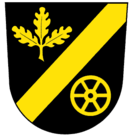
Riegelsberg district coat of arms
The coat of arms was approved on April 29, 1970.
Blazon : "In black a golden oblique left-hand bar, accompanied by a three-leaved golden oak branch at the top and a golden pulley at the bottom."
The colors of the district are black and yellow.
The sloping bar stands for the name Riegelsberg (see current coat of arms). The three oak leaves symbolize the abundance of forests in the area and, using numerical symbols, reproduce the former municipalities of Hilschbach, Güchenbach and Überhofen, which were merged to form the municipality of Riegelsberg on April 1, 1939. The sheave is a reference to the coal mining industry and the local mines.
The coat of arms was designed by H. Fell and H. Motsch.
Town twinning
Riegelsberg has partnered with since 1970 Gisors in the region Normandy ( France ).
Culture and sights
Regular events
- As part of the fair, there is a spring and autumn market with Sunday shopping on the market square and in front of the town hall in spring and autumn. Here companies and associations have the opportunity to present themselves and their work.
- The Riegelsberg market festival takes place every year on the second weekend in August. The market festival is very popular and attracts visitors from all over the Saarland.
theatre
- Bühnenvolksbund Riegelsberg (BVB) The amateur theater association in Riegelsberg since 1925. Mainly tabloid and crime comedies are performed. There are also modern fairy tales, but also classic fairy tales on the BVB program. The pieces are mainly performed in the Riegelsberghalle.
Buildings
- Evangelical Church (Riegelsberg)
- St. Josef Church (Riegelsberg)
- Hindenburg Tower: On December 2, 1934, the Hindenburg Tower was inaugurated as a memorial to those who fell in the First World War . Its construction goes back to a resolution of the Hilschbach-Güchenbach-Überhofen cemetery association. In a three-storey, 15 m high clinker building with a hall of honor, a statue of a soldier with a helmet and rifle was placed at his feet, created by the Saarbrücken sculptor Willi Knapp. The names of the 222 fallen in World War I from the three municipalities of Güchenbach, Hilschbach and Überhofen were also listed. The total costs for the construction measure amounted to 58,000 francs. After urgent renovation measures to preserve its substance, the tower was handed over to the people of Riegelsberg again on June 1, 1997. As a typical architectural monument for its time, the Hindenburg Tower was included in the Saarland monuments list. Today it is considered a symbol of peace and a memorial against war.
- Westwall bunker: The Westwall was a defense system that ran over 630 km and consisted of over 18,000 bunkers, tunnels and countless ditches and anti-tank barriers. It ran from Kleve in a southerly direction, along the western border of the former German Empire, to Weil am Rhein. Riegelsberg was on the main battle line of the west wall. There were a total of 16 bunkers here; a hump line designed as an anti-tank barrier began at Hilschbacher Wald and continued via Bietscheid to Berschweiler.
- Riegelsberghalle: On October 7, 1977, the Riegelsberghalle was inaugurated after only two years of construction. It is suitable for both sporting and cultural events. The hall offers space for 800 people for large events.
- St. Elisabeth (demolished in 2011)
Economy and Infrastructure
traffic
Riegelsberg is connected to the national road network via the federal highways 1 . Within Riegelsberg, the regional road network covers around 13 km, the urban network around 71 km. The main roads are the B 268 and the L 135.
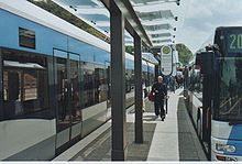
Since September 27, 2009, the Saarbahn has started regular operations to Saarbrücken on the Riegelsberg Süd - Walpershofen / Etzenhofen section. As a result, the situation of local public transport has improved significantly. With the seven new train stops, many citizens are no longer dependent on shuttle buses to the only stop 'Riegelsberg Süd' so far. The name "Riegelsberg Süd" was first introduced by the Saarbahn stop of the same name and was previously not known as a landmark. On October 31, 2011, another section of the Saarbahn was put into operation, which stops at two other stops in Riegelsberg. Districts that are not on the route will continue to be served by a total of four bus routes.
Personalities
Born in Riegelsberg
- Franz Annel (1903–1986), German clergyman
- Helmut Bulle (1925–1973), politician, 1965–1973 State Minister of the Saarland
- Franz Josef Conrad (1944–1985), politician, member of the Bundestag
- Fritz Klein (1898–1944), German resistance fighter
- Rainer G. Schmidt (* 1950), writer and translator
Connected with Riegelsberg
- Wilhelm Hector (1855–1918), well-known architect, built the St. Josefs House (so-called monastery) in Riegelsberg in 1898.
- Birgit Huonker (* 1961), works as a politician in Riegelsberg, member of the state parliament, state board member DIE LINKE and press spokeswoman, lives in Riegelsberg.
- György Kàroly László Lehoczky (1901–1979), architect and church window painter (Protestant church and elementary school in Riegelsberg).
- Bernd Wegner (* 1957), works as a politician in Riegelsberg, member of the state parliament, vice-president of the Saarland Chamber of Crafts.
- Volker Schmidt (* 1957), politician, member of the state parliament, lives in Riegelsberg.
- Detlev Schönauer (* 1953), German cabaret artist , lives in Riegelsberg.
- Dieter Thomas Heck (1937–2018) lived in Riegelsberg for several years.
literature
- Karl Heinz Janson, Franz Josef Warken: Riegelsberg and its old districts . Sutton, Erfurt 2012, ISBN 978-3-95400-064-7 .
- Karl Heinz Janson: Von der Heydt. A former part of Riegelsberg in the forest . Association for Industrial Culture and History eV, Riegelsberg 2017.
- Presbytery of the Evangelical Church Community in Güchenbach (ed.): 125 years of the Evangelical Church in Güchenbach in Riegelsberg. Festschrift for the 2013 Kirchweih anniversary . Evangelical church community Güchenbach, Riegelsberg 2013.
Web links
- Website of the municipality of Riegelsberg
- Literature on Riegelsberg in the Saarland Bibliography
- Link catalog on the subject of Riegelsberg at curlie.org (formerly DMOZ )
Individual evidence
- ↑ Saarland.de - Official population figures as of December 31, 2019 (PDF; 20 kB) ( help ).
- ^ Federal Statistical Office (ed.): Historical municipality directory for the Federal Republic of Germany. Name, border and key number changes in municipalities, counties and administrative districts from May 27, 1970 to December 31, 1982 . W. Kohlhammer, Stuttgart / Mainz 1983, ISBN 3-17-003263-1 , p. 806 .
- ↑ As of June 2009, website of the community
- ↑ Election of Mayor 2019. Riegelsberg municipality, accessed on August 4, 2019 .
- ^ Runoff election Mayor 2019. Riegelsberg community, accessed on August 4, 2019 .
- ↑ Election to the Riegelsberg municipal council in 2019. Riegelsberg municipality, accessed on August 4, 2019 .
- ↑ Election to the local council Riegelsberg 2019. Riegelsberg municipality, accessed on August 4, 2019 .
- ↑ Election to the Walpershofen local council in 2019. Riegelsberg municipality, accessed on August 4, 2019 .


