
Galgenberg (Wellheim)
| Gallows Mountain | ||
|---|---|---|
 The Galgenberg, view from the Dohlenfelsen near Konstein |
||
| height | 446.5 m above sea level NHN | |
| location | at Wellheim ; District of Eichstätt , Bavaria ( Germany ) | |
| Mountains | Franconian Alb | |
| Coordinates | 48 ° 49 '32 " N , 11 ° 5' 53" E | |
|
||
| Type | Umlaufberg | |
| rock | Dolomite stone | |
| particularities | former Umlaufberg of the Urdonau | |

The Galgenberg is 446.5 m above sea level. NHN high mountain in the Franconian Alb . It is located near Wellheim in the Upper Bavarian district of Eichstätt in Bavaria and is a former mountain of the original Danube . The survey is classified as Geotope Galgenberg near Wellheim .
geography
location
The Galgenberg rises in the Altmühltal Nature Park in the Wellheimer dry valley . Its summit is about 1.5 km northeast of the center of Wellheim, 1.8 km east of Konstein , 600 m south of Aicha and 2 km west-northwest of Hard .
At the north-west foot of the mountain is the Schutter spring, which is a designated natural monument . To the north, the small Johannisgraben flows through Aicha and to the south, in the transition area to Wellheim, the small Hardgraben. Both flow into the Schutter flowing southwest of the elevation through Wellheim.
Natural allocation
The Galgenberg belongs to the natural spatial main unit group Franconian Alb (No. 08), in the main unit Southern Franconian Alb ( 082) and in the subunit Altmühlalb (082.2) to the natural area Wellheimer Tal (082.25). Neighboring natural areas close to the mountains of the same subunit are Mittlere Altmühlalb (082.23) in the northeast and Obere Altmühlalb (082.22) in the northwest. Also, in mountain near neighboring natural areas located the adjacent subunit Donau side Frankenalb (082.1) and its branch Köschinger Forestry [082.1 (11)] are needle Schlager plateau (082.12) in the east, Hainbergalb (082.13) in the southeast and Tagmersheimer plateau (082.10) in the southwest.
Protected areas
Parts of the nature reserve protection zone in the Altmühltal nature park ( CDDA no. 396115; designated 1995; 1632.9606 km² ; LSG no. 00565.01) and parts of the fauna-flora-habitat area Galgenberg and Schutterquelle (FFH no . 7132-372; 11.51 ha ; WDPA No. 555521820). In addition, the survey is classified as Geotope Galgenberg near Wellheim (Geotope no. 176R033).
description
The Galgenberg rises about 50 m above the wide floodplain between Wellheim and Aicha. The dome, which is oriented in a south-east-north-west direction, is around 700 m long and up to 300 m wide.
The survey owes its name, Galgenberg, to a common place of execution with gallows of the prince-bishopric-Eichstättisches nursing office Wellheim and the Palatinate-Neuburgischen nursing office Konstein .
The elevation owes its origin to the original Danube , which once flowed through the Wellheim Valley. In the Miocene / Pliocene near Stepperg, a rock barrier blocked their way to the east. Therefore it ran to the north and flowed through today's dry valley in the direction of Dollnstein , further through the current Altmühltal to Kelheim . The local course of the Urdonau is proven by alpine rubble , which was carried from the Lech into the Danube and deposited by it as rubble. Such boulders can also be found on the eastern slopes of the Galgenberg.
The Galgenberg itself is made of resilient limestone and dolomite rock from the White Jura . In the southeast there is an outcrop of limestone from the Malm -Epsilon. The glacial stream initially flowed around the elevation in a large loop. Due to constant erosion on the impact slopes of the neck of the loop, the original Danube was later able to pierce this loop. The Galgenberg then stopped as a circular mountain in the middle of the valley.
During the Rift Ice Age , the original Danube was relocated in two stages. First it was tapped from the Schutter and for a short time followed its valley via Nassenfels - Buxheim . Later, a smaller river, which had already broken through the locking bar at Stepperg and created the breakthrough at Weltenburg , diverted the original Danube into today's valley through Neuburg and Ingolstadt . The Wellheimer Tal has been dry since then. Only the Schutter, which rises on the Galgenberg and flows into the Danube after about 30 km near Ingolstadt, still establishes the connection to this river past. The Schutter spring at the north-western foot of the mountain is a karst spring fed from greater depths .
The hill also served as a hilltop settlement during the Bronze Age and the Hallstatt Age . Today the managed Naturfreundehaus Konstein stands on the mountain slope a little east-southeast above the Schutter spring .
photos
Debris deposit in the east
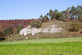
Malm outcrop

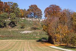
Summit area in autumn

Schutter spring at the foot of the mountain


Individual evidence
- ↑ a b c Map services of the Federal Agency for Nature Conservation ( information )
-
↑ a b Geotop: Galgenberg near Wellheim , at the Bavarian State Office for the Environment , accessed on December 23, 2015, at lfu.bayern.de (PDF; 385 kB)
- ↑ Galgenberg and Schutterquelle , accessed December 23, 2015, from protectedplanet.net
- ↑ Hill settlement of the Bronze Age and the Hallstatt Age , in Wellheim - architectural monuments from the Bavarian State Office for Monument Preservation , Wellheim Monument List, D-1-7132-0108, accessed on December 23, 2015, from geodaten.bayern.de (PDF; 133 kB)
Web links
- Galgenberg (mountain description), on naturpark-altmuehltal.de
- The creation of the Galgenberg (animation), on ingolstadt.de