Glatzer Schneeberg
| Śnieżnik Kłodzki / Králický Sněžník | ||
|---|---|---|
|
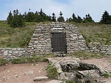
Glatzer Schneeberg from the south |
||
| height | 1425 m | |
| location | Czech Republic / Poland border | |
| Mountains | Glatzer snow mountains | |
| Dominance | 30.1 km → Praděd | |
| Notch height | 664 m ↓ Ramsauer Pass | |
| Coordinates | 50 ° 12 '27 " N , 16 ° 50' 51" E | |
|
|
||
The Glatzer Schneeberg , also Grulicher or Spieglitzer Schneeberg (Polish Śnieżnik Kłodzki , Czech Králický Sněžník ) is the highest mountain (1425 m above sea level ) of the Glatzer Schneegebirge in the western part of the Eastern Sudetes . The state border between Poland and the Czech Republic leads over the summit. The name of the mountain was derived from the long winter period, because the mountain is usually covered with snow for up to eight months a year. The upper part of the mountain is characterized by subalpine vegetation, the tree line is at an altitude of around 1200 m.
Location and surroundings
The Glatzer Schneeberg is located about 30 km south of Kłodzko ( Glatz ), 20 km north of Králíky ( Grulich ) and 30 km west of Jeseník ( Freiwaldau ). At its foot there are the towns of Międzygórze ( Wölfelsgrund ), Kletno ( Klessengrund ), Velká Morava and Staré Město ( Moravian Old Town ). After the demolition of the shelter on the summit, the former Swiss farm on the Schneeberg ( Schronisko na Śnieżniku ) below the summit is the only remaining mining hut on the Schneeberg massif on the Polish side . The stalactite cave labyrinth Jaskinia Niedźwiedzia , discovered above Kletno in 1966 during drilling work, consists of several levels and contains the bones of Ice Age animals and traces of human settlement. Parts of the stalactite cave are open to inspection. A bit below the summit is the Vlaštovčí Kameny rock group - with a block heap at the foot.
The watershed point of the North Sea – Baltic Sea – Black Sea

The Trójmorski Wierch ("Dreimeereberg", German Klapperstein , Czech. Klepý ), a side peak of the Schneeberg massif (1145 m, 50 ° 9 ′ N , 16 ° 47 ′ E ) is an important European watershed point . The at an altitude of 1380 m on the southern slope of the mountain springing March (Pol. Morawa , tschech. U. Slowak. Morava ) flows across the Danube to the Black Sea , the Glatzer Neisse ( Nysa Kłodzka ) flows across the Oder in the Baltic Sea and the Lipkovský potok ( Lipkauer Bach ) reaches the North Sea over the Elbe .
history
On the Silesian side there was a stone mining hut with the 30-meter-high Kaiser Wilhelm tower, which was blown up by the Polish army in 1973 because it was dilapidated. The rubble now forms the highest point of the mountain. Historically, the Kingdom of Bohemia , the Margraviate of Moravia and the County of Glatz border each other on the summit . A historical heraldic stone marks this point.
natural reserve
The area still shows extensive damage from air pollutants, in particular from coal burning in the post-war years ( forest dieback ).
The Czech National Nature Reserve Králický Sněžník was proclaimed in 1990. It occupies an area of 1694.67 hectares . A protection zone with an area of 1371.24 hectares was also established to contain disruptive influences from the surrounding area. In addition to subalpine areas with Knieholz and raised bogs , remains of primeval forest can be found below the tree line with the spruce species and endemic plants typical there . The reserve is also important as a bird sanctuary .
On the Polish side, there has been Śnieżnicki Park Krajobrazowy ( Snow Mountains Landscape Protection Park ) since 1981 , which extends to 28,800 hectares and whose special protection zone comprises 14,900 hectares, which is why no ski lifts are allowed to be built around the mountain and an opening up of the region for the Winter sports are only possible to a limited extent. Wild boars , badgers , chamois , black storks , rare woodpecker species and endemic plant species live in the area of the nature park .
geology
The geology of the mountain is determined by metamorphic rocks such as gneiss and mica schist . Sometimes there are also crystallized limestones ( marble ), dolomite , amphobolite , amphibolite slate , quartzite and quartzite slate . The flanks of the mountain were shaped by glaciers in the ice ages ; a variety of form elements emerged, such as block heaps, moraines and hollows.
Paths to the summit
- The most favorable starting point is the resort of Międzygórze , from there the path leads over the former Switzerland to the summit plateau.
- From Kletno a path leads over the bear cave to the summit.
- Other starting points are Staré Město and Velká Morava.
- The European E3 long-distance hiking trail and the Eisenach-Budapest mountain hiking trail lead over the mountain .
See also
Individual evidence
- ↑ Králický Sněžník on peakbagger , accessed on November 19, 2018
- ↑ Acid rain and dying forest ( Memento of the original from September 24, 2011 in the Internet Archive ) Info: The archive link was inserted automatically and has not yet been checked. Please check the original and archive link according to the instructions and then remove this notice. University of Zurich, Social and Economic History
- ↑ Photo impressions 2004 from Schneeberg
Web links
- Historical recordings
- Sneznik.cz (Czech)


