Grüna (Loessnitz)
|
Grüna
City of Loessnitz
|
|
|---|---|
| Coordinates: 50 ° 38 ′ 51 ″ N , 12 ° 44 ′ 1 ″ E | |
| Height : | 507-555 m |
| Area : | 85 ha |
| Residents : | 105 (2008) |
| Population density : | 124 inhabitants / km² |
| Incorporation : | 1st February 1974 |
| Incorporated into: | Affalter |
| Postal code : | 08294 |
| Area code : | 03771 |
|
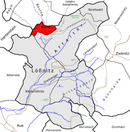
The location of Grüna in the city of Lößnitz
|
|
The western Ore Mountains village Grüna (formerly Grune for place in the green ) is a district of the mountain town of Lößnitz in the Ore Mountains District , Saxony , Germany and is thus part of the Silberberg Association of Cities .
geography
The forest strip village Grüna is a settlement of 13 farmsteads and is located about seven kilometers north of Aue in the Ore Mountains on the southwest slope of the mountain Katzenstein , and east of a flat saddle with about 540 m above sea level. NN. The location increases slightly from the west (approx. 525 m) to the east (approx. 550 m).
The Katzenstein belongs to the northern part of the Zwönitz plateau, which extends in the south to Kühnhaide . The Zwönitz plateau, on which Grüna is also located, consists mainly of only slightly to moderately sloping sloping hollows and trough valleys, which mainly drain towards Chemnitz . Grassland is found in the mostly wet hollow forms. The flat ridges of the plateau are mainly used for agriculture. The rocks of the Katzenstein also provide rock-rich and at the same time nutrient-poor soils. However, there are more favorable relief conditions compared to the Lößnitzgetäle. The plateau, which towers noticeably over the western and northern surroundings, is exposed to strong winds. The exposed position of the Katzenstein causes climatic windward effects in north-westerly weather conditions.
The Beuthenbach, a source branch of the Würschnitz, rises on the local border with Beutha . The source area itself and the first 500 m of the stream are piped up and therefore no longer visible.
The following places border on Grüna (starting clockwise from the north): Beutha , Affalter , Lößnitz and Hartenstein .
traffic
Grüna has two streets: Dorfstraße and Beuthaer Straße. The Dorfstraße connects Grüna with the federal highway 169 and the Beuthaer Straße with the Lößnitzer Straße, which leads to the A 72 .
history
The small forest strip with a corridor of just 85 hectares suggests a late foundation which belonged to the Hartenstein estate . The first known records date from 1528 when the new green and from the year 1539 as Grune , for location in the countryside . In the 18th century it was referred to as camphor green ( desert ?) And in the 19th century as Waitzengrün . As early as 1660 it was designated as a 12-garden estate settlement . These 12 small farmers, so-called gardeners, cultivated the land and, from the 18th century, also operated stocking- making . The hosiery loom was usually located in an extension. With the advent of mechanical knitting machines in factories, this house trade ceased in Grüna and the farmers leased land from the neighboring communities. In 1925 all 78 residents belonged to the Evangelical Lutheran denomination . Three quarters of the workforce were employed by LPG Frischer Wind (Type I). In the population census in 1964, Grüna had by far the lowest number of inhabitants among the communities in the former Karl-Marx-Stadt district . In 1974 the village was incorporated into Affalter , the same also applied to the workers of the LPG Frischer Wind , who have been working for the LPG Affalter since then.
The small community was always pastured to Lößnitz and, since Affalter was incorporated into Lößnitz on January 1, 1999 , it has also belonged to the mining town as a district. The schooling takes place in the neighboring village of Beutha , at the request of the parents Lößnitz can also be chosen. Until July 31, 2008 the place belonged to the now defunct Aue-Schwarzenberg district . The structure of the place has been largely preserved to this day.

Population development
The following population figures relate to the commune of Grüna:
|
1546 to 1871 |
1890 to 1939 |
1946 to 1964 |
- Source: Digital Historical Directory of Saxony, City Council Lößnitz (2008)
Former railway line
As early as 1873, Polish and Italian workers carried out earthmoving work for the Zwönitz – Stollberg railway line . Although the construction company went bankrupt a little later, this 16.6 km long secondary line was opened on July 15, 1889 after a construction period from October 1887 to July 1889. The route via Grüna was primarily intended for coal traffic from the Oelsnitzer Revier to the Ore Mountains. Regular passenger traffic was discontinued on October 10, 1966, and freight traffic a year later. The complete shutdown took place on January 1, 1971. The dismantling of the tracks began in December 1972.
Today the grounds of the Grüna volunteer fire brigade are located in the old railway cut, where the Day of German Unity is celebrated every year with a large fire brigade festival. Among other things, the extinguishing attack is carried out for a time with many fire departments from the area using GDR technology .
literature
- Between Zwickauer Mulde and Geyerschem Wald (= values of our homeland . Volume 31). 1st edition. Akademie Verlag, Berlin 1978.
- Eberhard Schramm: The Upper Ore Mountains Lookout Railway - The Stollberg – Zwönitz – Scheibenberg route. EK-Verlag, Freiburg 1996, ISBN 978-3-88255-427-4 .
Web links
- Grüna in the Digital Historical Directory of Saxony


