
Guatemala City
| Guatemala City | |
|---|---|
|
Coordinates: 14 ° 38 ′ N , 90 ° 31 ′ W
Guatemala City on the map of Guatemala
|
|
 Location of Guatemala City in Guatemala
|
|
| Basic data | |
| Country | Guatemala |
| Department | Guatemala |
| City foundation | 1620 |
| Residents | 1,010,253 (Ber. 2006) |
| - in the metropolitan area | 2,944,065 (department) |
| City insignia | |
 |
 |
| Detailed data | |
| surface | 228 km 2 |
| Population density | 4,505 inhabitants / km 2 |
| height | 1533 m |
| City structure | 21 zonas |
| Post Code | 01001-01021 |
| Time zone | UTC −6 |
| Website | |
 |
|
 |
|

Guatemala City ( Spanish Ciudad de Guatemala , officially La Nueva Guatemala de la Asunción ) is the capital of the Central American state of Guatemala .
history
The earliest settlement by the Maya occurred more than 2000 years ago. The ruins of this settlement ( Kaminaljuyú ) can now be viewed in a park in the city center. During the Spanish colonial era, the small town of Ermita was built around a monastery ( El Carmen ) from 1620 , which in 1773 had around 1,600 inhabitants. After the old capital Antigua Guatemala fell victim to an earthquake on July 26, 1773, Guatemala City was founded on September 27, 1775 as the new capital of the Spanish colonial area in Central America . In 1782 a population of 13,000 people was counted.
From 1823 until the transfer of government to San Salvador in 1834, Guatemala City was the capital of the Central American Confederation, which was dissolved again in 1840 . The political turmoil at that time prevented further expansion of the city, which also had to struggle with Quetzaltenango for supremacy in the country.
At the end of the 19th century, classicist architecture shaped the city, which at that time only had about 70,000 inhabitants. Severe earthquakes destroyed large parts of the city in 1830, 1917, 1918 and especially in 1976. After the earthquake of 1976, countless refugees from other departments came to the capital, which experienced a population explosion in the course of its modern reconstruction, which also included the surrounding municipalities.
Cityscape
Guatemala City is located on a high plateau in a temperate climate. The loose volcanic tuff of the subsoil is cut through in many places by deep erosion gorges (“barrancos”), which sometimes forces traffic to make long detours.
When the city was founded in 1773, the streets were laid out at right angles around a central square. The old town has a relatively low construction, which can be traced back to an earthquake protection ordinance of 1918, according to which no more than two storeys could be built.
population
Today Guatemala City has a little over a million inhabitants, making it the largest city in the country. The agglomeration , which is often mistakenly equated with Guatemala City, includes Mixco , Villa Nueva and a few other places that have evolved from smaller villages to cities over the past few decades and have de facto merged with Guatemala City. According to official information, around 2.5 million people live in this metropolitan area, and around 3.3 million in the department (as of 2015).
Tourist Attractions
- National Museum of Archeology and Ethnology
- Museo Ixchell (Indian textiles)
- Museo Nacional de Arte Moderno "Carlos Mérida" , museum of modern art
- Museo Popol Vuh ( pre-Columbian art)
- Kaminaljuyú (pre-Columbian Mayan ruin )
- Torre del Reformador
- Palacio Nacional (National Palace)
- Catedral Metropolitana (cathedral from 1815 with rich art furnishings)
- Palacio Episcopal (Archbishop's Palace)
- Biblioteca Nacional (National Library)
- Archivo General de Centro America (archive with numerous documents from colonial history)
- Iglesia Cerrito del Carmen
- Iglesia La Merced (Neoclassical Church from 1813)
- Iglesia San Francisco (Neoclassical church from 1851 with rich art furnishings)
- Museo Nacional de Historia (National history in the 19th century)
- Teatro Nacional (national theater , built in 1978 in the shape of a ship)
Universities
- University of San Carlos de Guatemala
- Rafael Landívar University
- Francisco Marroquin University
- University of Mariano Galvez
- University of Del Valle de Guatemala
- Galileo University
One of the five Austrian schools abroad is located in Guatemala City . In addition to studying at a university in Guatemala, the qualification also entitles you to study at an Austrian university. In an evaluation in 1999 it was rated as the best school in the country.
The Guatemalan army maintains the military academy Escuela Politécnica and the General Staff Academy Comando Superior de Educación del Ejército in the city .
Sports
The No. 1 popular sport is football . The most popular clubs among the people are CD Municipal ("Los Rojos") and CSD Communicaciones ("Las Cremas"). Home games of the Rojos take place in the national stadium "Mateo Flores" in the Zona 1, the home games of the Cremas further outside in the Estadio "Cementos Progresso". At city derbies - so-called Classicos - between the two clubs there are always five-digit visitor numbers. Due to the great rivalry, the city derbies not only have a good atmosphere but also often lead to serious riots. The third largest club in the city of Aurora FC is based in the Estadio Ejercito.
Economy and Infrastructure
The Guatemala City , since its 2007 renovations it as modernster commercial airport in Central America.
Collapse formations

In February 2007, a large hole opened in the ground in northeast Guatemala City ( 14 ° 39 ′ 1.6 ″ N , 90 ° 29 ′ 27.2 ″ W ), killing three people. The hole was 60 meters deep and 30 meters in diameter, after which 1000 people were relocated.
Another hole formed in May 2010 after tropical storm Agatha and swallowed a three-story building. ( 14 ° 39 ′ 7.3 ″ N , 90 ° 30 ′ 21.3 ″ W )
It is not yet clear whether these are sinkholes , known in this region as cenotes , as a consequence of karst or pseudo-karst . Possible influences of the urban sewer system are also examined.

Climate table
| Guatemala City | ||||||||||||||||||||||||||||||||||||||||||||||||
|---|---|---|---|---|---|---|---|---|---|---|---|---|---|---|---|---|---|---|---|---|---|---|---|---|---|---|---|---|---|---|---|---|---|---|---|---|---|---|---|---|---|---|---|---|---|---|---|---|
| Climate diagram | ||||||||||||||||||||||||||||||||||||||||||||||||
| ||||||||||||||||||||||||||||||||||||||||||||||||
|
Average monthly temperatures and rainfall for Guatemala City
Source: wetterkontor.de
|
|||||||||||||||||||||||||||||||||||||||||||||||||||||||||||||||||||||||||||||||||||||||||||||||||||||||||||||||||||||||||||||||||||||||
sons and daughters of the town
- Antonio José de Irisarri (1786–1868), first Director Supremo of Chile (1814)
- José Escolástico Andrino (1817–1862), composer, violinist and music writer
- Jorge Ubico Castañeda (1878–1946), Guatemalan President and dictator from 1931 to 1944
- Rafael Yela Günther (1888–1942), sculptor and painter
- Carlos Mérida (1891–1984), Guatemalan-Mexican painter and lithographer
- Miguel Ángel Asturias (1899–1974), writer, diplomat, Nobel laureate in literature
- Alfred Jensen (1903–1981), American painter
- Emilio Arenales Catalán (1922–1969), politician
- Juan José Gerardi Conedera (1922–1998), Roman Catholic bishop
- Rina Lazo (1923–2019), painter and graphic artist
- Óscar Humberto Mejía Víctores (1930–2016), General, Guatemalan head of state from 1983 to 1986
- Rodolfo Francisco Bobadilla Mata (1932–2019), religious, Roman Catholic Bishop of Huehuetenango
- Rodolfo Quezada Toruño (1932–2012), Archbishop of Guatemala and Cardinal
- Gustavo Rodolfo Mendoza Hernández (* 1934), Catholic clergyman, auxiliary bishop emeritus in Guatemala
- Joaquín Orellana (* 1930/1937), composer
- Luis Díaz (* 1939), painter, graphic artist, sculptor and architect
- Enrique Anleu Díaz (* 1940), composer, musicologist and ethnomusicologist
- Óscar Berger Perdomo (* 1946), politician and President of Guatemala
- Sergio Custodio (1947–2020), philosopher, theologian and professor in the field of logic and metaphysics
- Ted Hendricks (born 1947), American football player
- Óscar Julio Vian Morales SDB (1947–2018), religious priest and Roman Catholic Archbishop of Guatemala City
- Álvaro Colom Caballeros (* 1951), politician and President of Guatemala
- Carlos Enrique Trinidad Gómez (1955–2018), Bishop of San Marcos
- Alejandro Giammattei (* 1956), politician and President of Guatemala
- Celvin Galindo (* 1957), public prosecutor
- Antonio Calderón Cruz (* 1959), Bishop of Jutiapa
- Carlos Batres (* 1968), football referee
- Jimmy Morales (* 1969), politician and President of Guatemala
- Carlos Humberto Ruiz Gutiérrez (* 1979), football player
- Gaby Moreno (* 1981), singer, songwriter and guitarist
- Shery (* 1983), pop songwriter and singer
- Marco Pappa (* 1987), soccer player
Town twinning
-
 Hollywood , USA
 -
 La Paz , Bolivia
 -
 Mexico City , Mexico
 -
 San Juan , Puerto Rico
 -
 San Salvador , El Salvador
 -
 Santa Cruz de Tenerife , Spain
 -
 Taipei , Taiwan
 -
 Trujillo , Peru
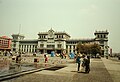
National Palace in the old center
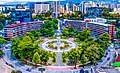
Plaza España
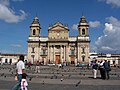
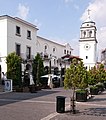
Cathedral in the old center
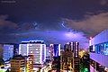
Zona Viva modern district

Former main post office building
Paseo Cayalá modern district, zone 16


miscellaneous
Individual evidence
- ↑ http://www.ine.gob.gt/index.php/estadisticas/tema-indicadores
- ^ A b Rodolfo G. Hermosilla: The Guatemala City sinkhole collapses . In: Carbonates Evaporites . Springer, 2011, ISSN 0891-2556 , doi : 10.1007 / s13146-011-0074-1 .
- ↑ David L Miller: Massive Guatemala Sinkhole Kills 2 Teens . CBS News. July 4, 2009. Retrieved July 8, 2009.
- ↑ https://www.theguardian.com/world/2010/jun/01/storm-agatha-hole-guatemala