
Hurry
|
district of Remscheid |
|
|---|---|
 |
|
| Coordinates | 51 ° 11 '47 " N , 7 ° 9' 57" E |
| height | 260 m |
| surface | 0.57 km² |
| Residents | 1994 (December 31, 2015) |
| Population density | 3498 inhabitants / km² |
| prefix | 02191 |
| Borough | Old Remscheid |
| Transport links | |
| bus | 615 653 657 675 680 NE15 NE17 |
Hasten is a district of the Bergisch city of Remscheid in North Rhine-Westphalia . The statistical district of Hasten Mitte forms the core of the district.
In local parlance, the term branch has also become established, which can be traced back to the fact that the first Protestant church outside of today's core city area was founded on Hasten in 1853.

history
In 1312 Hasten was first mentioned as "hassytthen". It was not until 1639 that the term "to the Horsten" came into play. According to the Lippe field names, "Horst" or "Harst" stands for "Hast" and Hurst "and thus for undergrowth and bush. The term" Om Hasten "was and is common in Low German.
location
Hasten is located in the northwest of the city in the district of Alt-Remscheid at an altitude of about 260 meters above sea level on the central Richard-Lindenberg-Platz and thus a good 100 meters lower than the city center. In the north and west, the district is surrounded by the Morsbach, which is another 100 meters lower and forms the border with Wuppertal ( Cronenberg district ) over long stretches . The city park with the area “in the marshes” and the Edelhoff park begin above Hastener Strasse near “Schöne Aussicht”.
The locations Büchel , Holz, Feld , Hütz , Platz , Gerstau and Haster Aue belong to Hasten .
Infrastructure and economy
Hastener Strasse (Landesstrasse 415), which connects Remscheid with Wuppertal, runs through Hasten . In Gerstau it crosses Landesstrasse 216 ( Morsbachtalstrasse ), which leads around Hasten to Müngsten .
The long disused tram line Elberfeld – Cronenfeld-Remscheid ran through Hasten and crossed the Ronsdorf-Müngstener railway line in Gerstau . Another tram line led from Clarenbach to the beautiful view , where there was a connection to the first line. Today city bus routes connect the district with the center of Remscheid and with Wuppertal.
On September 1, 1883, the 4.25 km long section from Remscheid station to the newly built Hasten station was the last section of the Lennep – Hasten railway , which in Lennep to the Wuppertal-Oberbarmen – Opladen railway and at Remscheid station from 1897 on the Wuppertal-Oberbarmen-Solingen railway line . Passenger traffic ended in 1922, freight traffic ceased on January 1, 1991. After dismantling the rails, the tool route was opened on it as part of the Regionale 2006 , a cycle and hiking trail that conveys aspects of tool and metal processing to the visitor. The operating buildings of the railway were demolished, mainly retail companies have settled on the former railway site.
There are numerous large and small companies in the metalworking industry in Hasten ; the companies Edscha and Keiper were founded on the Hasten. In 1906 Richard Lindenberg built the world's first electric steelworks to work according to the Héroult-Lindenberg system on the Hasten, his company Edelstahlwerke Lindenberg, the world's first industrially used electric steel furnace. The Stahlwerke Richard Lindenberg AG were later merged into the Deutsche Edelstahlwerke AG. The former company area is now called "Glockenstahl-Straße" and includes a variety of companies of all kinds. In the neighborhood there was a sports field called "Glockenstahl-Kampfbahn", which was mainly used by the VfB Marathon, until the end of the 20th century.
At Richard-Lindenberg-Platz and on Hastener Straße there are numerous retail stores, restaurants and service providers. From the former Café Nordmeier, a factory for diet pralines developed under the direction of Wolf Nordmeier, which is located on Hastener Straße. There has also been a Protestant cemetery on Jöstingstrasse for a long time . The former water tower was demolished before the end of the 20th century when the water bunker next to the observatory in the city park took over the control function for the water supply in Hasten.
Attractions
The townscape is still characterized by numerous, mostly slated half-timbered houses - especially on Büchel. There are also a number of manufacturers' villas. In one of them, Haus Cleff , is the "Museum Haus Cleff". Today it is part of the historical center of the city of Remscheid . This also includes the neighboring German Tool Museum , which, among other things, houses an extensive collection of tools and illustrates the development of tool production.
The Pauluskirche was built on the border between Hasten and Büchel in neo-Romanesque style and inaugurated in 1853 as a branch church of the town church. It was built at the expense of the Hastener and Büchel parishioners, the parish only became independent in 1872, but the name Filiale was retained. The Remscheid-Hasten water tower was built nearby in 1909 and was demolished in 1982.
societies
- Hastener gymnastics club
- School association GGS Hasten
- Allotment garden association Hasten-Büchel
- Association for German Shepherds, local group Hasten
- Formerly there was the "bowling club Hasten"
Views from the district

House Cleff, front with outside stairs
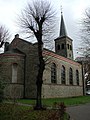
Pauluskirche Hasten

Flag of the former bowling club Hasten


Web links
Individual evidence
- ^ A b Hans Jürgen Roth: History of our city, Remscheid with Lennep and Lüttringhausen , RGA-Buchverlag, Remscheid, 2009, ISBN 978-3-940491-01-5 , p. 209

District 1 Alt-Remscheid : 101 Remscheid-Mitte | 102 Nordstadt | 103 Old Town | 104 Stachelhausen | 105 Blumental | 106 Honsberg | 107 City Park | 108 Scheid | 201 Hasten-middle | 202 Kratzberg | 203 Haddenbach | 204 Nice view | 401 Morsbach | 402 Vieringhausen | 403 Kremenholl | 404 Reinshagen | 405 Westhausen
District 2 Remscheid-Süd : 301 central point | 302 Neuenkamp | 303 spruce height | 304 Wüstenhagen | 305 Bökerhöhe | 306 Mix Siepen | 307 Struck | 308 Falkenberg | 309 Bliedinghausen | 310 Ehringhausen
District 3 Lennep : 501 Lennep Altstadt | 502 Lennep Nord | 503 City Garden | 504 Lennep Neustadt | 505 Lennep West | 506 Hackenberg | 507 Henkelshof | 508 Hasenberg | 509 trek nose | 510 border wall | 511 Castel Sant'Angelo | 512 Bergisch Born Ost | 513 Bergisch Born West
District 4 Lüttringhausen : 601 Lüttringhausen Mitte | 602 Klausen | 603 Großhülsberg | 604 Garschagen | 605 Schmittenbusch | 606 Stursberg | 607 Dörrenberg | 608 Goldenberg | 609 Lüttringhausen West