Hut (Marienheide)
|
hut
Municipality Marienheide
Coordinates: 51 ° 3 ′ 18 ″ N , 7 ° 30 ′ 6 ″ E
|
||
|---|---|---|
| Height : | 245-262 m | |
| Residents : | 66 (Jan 1, 2008) | |
| Postal code : | 51709 | |
| Primaries : | 02264, 02261 | |
|
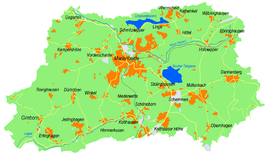
Location of hut in Marienheide |
||
Hut is a village in the municipality of Marienheide in the Oberbergisches Kreis , North Rhine-Westphalia , Germany .
Location and description
The place is on the road 97 (connection between Lindlar and Marienheide) about 4.5 km from the main town in the Leppetal .
history
First mention
The place was first mentioned in a document around 1535, namely "Kerstgen and Peter op der Hütten are mentioned in a tax list".
The spelling of the first mention was op der Hütten .
Hiking and biking trails
The Marienheider local hiking trail A4 (Gimborn - Grunewald - south of Siemerkusen - Winkel - Hut - Dürhölzen - Jedinghagen - north of Erlinghagen - Gimborn) with a length of 9.5 kilometers crosses Hut.
Bus and train connections
Public bus
Stop: Hut
- 307 towards Frielingsdorf - Lindlar
- 307 direction Gummersbach Bf
- 308 towards Frielingsdorf - Engelskirchen
- 308 towards Marienheide
Former railway line
The station hut or Hülsenbusch was due to the Leppetalbahn which shut down is.

