
Handalm
| Handalm | ||
|---|---|---|
 The Handalm |
||
| height | 1853 m above sea level A. | |
| location | Deutschlandsberg District , Styria , Austria | |
| Mountains | Koralpe | |
| Dominance | 2.44 km → Brandhöhe | |
| Notch height | 183 m ↓ Weinebene | |
| Coordinates | 46 ° 50 '48 " N , 15 ° 1' 11" E | |
|
||
| rock | Slab gneiss | |
| Development | Hiking trails | |
| Normal way | from the wine level | |

The Handalm is a mountain in the middle Koralpe . It is 1853 m high and lies north of the Weinebene .
The next higher peak is the Brandhöhe (1886 m) south of the Handalm, which in turn is a pre-summit of the Moschkogel (1916 m). The height of the gap in the Handalm is 183 m (Weinebenstraße), its dominance 2.5 km.
geography
The Handalm is located on the ridge of the Koralpenzuges on the border between Styria and Carinthia. The summit area belongs entirely to Styria (municipality of Deutschlandsberg ), the border coming from the northwest turns about 250 meters south of the Handalm summit to the south towards Weinebene. The slope south of the summit is in the Styrian community of Schwanberg , the slope in the southwest belongs to the Carinthian community of Frantschach-Sankt Gertraud .
The summit of the Handalm is around 150 m above the tree line , which in this area is around 1700 to 1800 meters. The summit area is formed by a small plateau overlooked by some rock groups. In the northern part of these groups is the trigonometric point . At the Handalm, a branch branches off from the north-south ridge of the Koralpenzuges to the east with the next peaks Moserkogel (Moseralm), Glashüttenkogel and Kumpfkogel. In the northeast is the place Osterwitz.
In the west of the Handalm the ridge of the Koralpenzug continues with the Weberkogel (also called "Wildbachalm"), the mountain range then swings north into the Hebalm area . In the north of the Handalm, the area of origin of the Laßnitz lies in vast, almost unpopulated forests, several square kilometers in size, which largely belong to the Liechtenstein family's forest estate . These forests are accessed by forest roads that are closed to general traffic. Until 1959, the northern feeder route of the Deutschlandsberg forest railway ran in this area . The Osterwitzbach rises on the northeast slope of the Weinebene, and flows into the Laßnitz near Freiland near Deutschlandsberg . To the south of the Handalm lies the Weinebene, via which there is a connection between western Styria and the Lavanttal via the Weinebenstraße.
In the saddle between Handalm and Moserkogel is the hand-height cross. It refers to the point where the old road connection between Weinebene and Osterwitz crossed the ridge. Since the Handalm is often surrounded by thick fog due to its altitude, this cross is an important waymarker.
The Handalm is an old pasture area, the cattle were supervised by shepherds. Lists of names of the shepherds and details of their living conditions are published. On the slopes around the Handalm there are cattle goats that date from the time when the Alm was used more intensively as pasture. The sward is often only thin, in steeper places it slips off and forms plaques of different sizes.
The Paulus Chapel is located at the foot of the southern slope of the Handalm at the Weinebene. It was built in honor of St. Paul , the patron saint of long-distance hikers, in 1982/83. In it there is a statue of St. Paul made from Waldviertel granite , which was created by the sculptor Carl Hermann .

geology
The Handalm consists of transformed ( metamorphic ) rock , the Koralm crystalline . This is essentially gneiss that was created by high pressure and high temperatures. It is shaped into plates that are centimeter to decimeter thick and contains garnet crystals . The rock of the Handalm is known as the " Stainz slab gneiss : blastomylonitic, flat eye gneiss". It is part of one of the eight published slab gneiss areas in the eastern Koralpe, the "Complex 5 Handalm-Trahütten". The strike in this slab of gneiss mainly follows the northwest-southeast direction, the fall is up to 30 degrees , the lineation up to about 15 degrees to the north. These values are based on the geological processes when the Koralpe was formed.
The slopes of the Handalm largely consist of debris and rubble heaps (partly from the Würm ), on these slopes there are also some pegmatites and marble lenses . The geology of the Handalm, like that of the entire Koralpe, has been thoroughly investigated. In addition to the works of Peter Beck-Mannagetta , whose specialty was the geology of the Koralpe, other authors also dealt with this topic early on.
The Handalm does not have a pronounced summit area. This is due to the fact that the Koralpe, in which the Handalm is located, is geologically a part of the mountain that has been raised as a whole , a so-called Pultscholle , the individual peaks of which are not created by unfolding rock masses , as in other mountains , but rather by unevenly weathering individual rock areas . The Koralpe and with it the Handalm received the foundations of their present form in the last part of the mountain formation of the Alps about 20 million years ago.

Whether the Handalm in the ice ages ver gletschert was open. One map shows glaciation, another publication indicates that no moraine remnants have been found that would indicate glaciation.
The ridge to the east, which begins at the Handalm, is seen as one of the proofs of the original structure of the Koralpe, it is an indication of a tectonic northwest-southeast stripe of this mountain range, which was later revised by a north-south alignment. The Handalm is also on the northern edge of a flat bulge of the Koralpen mountain block, the "Wolfsberger Antiklinale " , which can no longer be recognized in the terrain without specialist information .
Whether the lithium deposit , which was discovered south of the Weinebene, extends into the area of the Handalm is open, because the extent of this deposit has not yet been explored.

Rock ovens
Characteristic for the Handalm are a series of rock groups ( ovens ) that protrude from the otherwise slightly undulating alpine floor. These are the results of uneven weathering of the rock that makes up the Handalm. The rock groups consist of more or less thick stacks of gneiss slabs. This area of the Handalm is part of a day stage of the Koralm Kristall Trail.
- Hand-held ovens

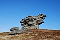
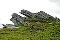


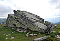


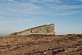


Positions of three of the ovens: hand oven 1 hand oven 2 hand oven 3

vegetation
The vegetation belongs to the subalpine to alpine altitude range . The Handalm is overgrown with spruce forest up to the tree line , followed by growth of pine trees . The floor is in the forest with raw humus and where the trees loose, with blackberry bushes , bristle grass , ferns , mosses and clumps of Almrausch covered. Plants of the hellebore is often because they are not accepted because of their toxicity from grazing livestock. The vegetation of the summit area consists of lichens and mosses, which cover the ground as a mat, on other areas, especially on the slopes, there are bristle grass willows .
Development
The Handalm is accessible by hiking trails: It is located on the European long-distance hiking trail E6 , the north-south long-distance hiking trail 05 , the Styrian state circular hiking trail, the Carinthian circular hiking trail and on the Via Alpina ( purple trail, stage A 18 ). Other regional hiking trails such as the Koralm-Kristall-Trail and the Lavanttaler Höhenweg also lead over the Handalm. The only public road in its catchment area is the road across the Weinebene in the south. From there, the summit area of the Handalm can be reached via a partly steep hiking trail in around 20-40 minutes, depending on the exercise (around one kilometer and 200 meters in altitude). A road that branched off at the Weinebene led up to the 1940s over the southern slope of the Handalm, the location of the Handalmkreuz and the Posch-Alm towards Osterwitz. At that time it was still passable with off-road vehicles, but then it fell into disrepair and only remnants can be seen. The hiking trail to the Handalmkreuz partly follows the course of this old road.
Wolfstein

In the northwest of the Handalmzug there is the Wolfstein on the Wildbach saddle. This is a memorial stone that commemorates the killing of a large wolf on March 5, 1914: In 1913, this animal had caused unrest in the central Koralpen region, tore down numerous sheep, cattle and other domestic animals and had become the subject of local myths. At that time it was the last wolf in this area and was called the "Bauernschreck".
Handalm wind farm

From 2012 to 2016, the steel mast of a weather station was located in the center of the rock groups on the Handalm plateau . This mast is 50 meters high and guyed with steel cables on three sides. It was part of the Handalm and Weinebene wind measuring systems, which consisted of three such masts . A second mast was located by the wine oven south of the Weinebene, a third on the Weberkogel northwest of the Handalm. These measuring stations were part of the preparations for the Handalm wind farm.
The Handalm is located in a priority zone for the use of wind energy , which was decided by the Styrian state government in the development program for the field of wind energy (Sapro Windenergie) in June 2013. Three square kilometers are shown along the approximately five-kilometer ridge from the Brandhöhe to the Kumpfkogel .
Eleven turbines with 72,600 MWh annually were planned in this area as part of the NER300 program . In 2012, the project was one of the top projects for funding from the European Union.
The Handalm wind farm was added to the list of funded projects in December 2012 with a maximum amount of 11.3 million euros. It was discussed whether the energy obtained from wind power can be used to operate a pumped storage power plant in the vicinity and thus make it storable.
After completion of the environmental impact assessment, work on the wind farm was announced in March 2016 for summer 2016. There were 13 wind turbines with a total output of 39 megawatts (MW), the total amount of generated green electricity will be 76 gigawatt hours (GWh, million kilowatt hours) per year, which is only (depending on the wind) around 6 GWh less than the amount of energy from the Mur power plant in Graz . The work on the wind farm lasted two years; 150 individual editions were planned for the protection of wild animals, birds, bats and the surrounding alpine pastures and forest areas. The area of the wind turbines is opened up by an extension of an existing forest road, which branches off from Weinebenstraße. As of October 2017, the wind turbines will supply more than 21,000 households with electricity. The rotor blades individually weigh 8 tons, a wind turbine has a diameter of 82 meters, the turbines are each approx. 120 meters high. A foundation weighs around 1000 tons, a hub (at a height of 78 meters) around 19 tons, and 58 million euros have been invested in the system. The wind turbine is connected to the Deutschlandsberg substation by a 17 km long transport line.
The wind farm was opened on October 24, 2017. Ski racer Renate Götschl was the sponsor of the 100th Styrian wind turbine operated there, which was given the name "Renate" .
Web links


Individual evidence
- ^ Gerhard Fischer: Osterwitz. a miraculous place in the high pürg. Life, joy and suffering of an area and its inhabitants. Osterwitz 2002. Editor and publisher: Osterwitz community. Production: Simadruck Aigner & Weisi, Deutschlandsberg. Pages 416-418, 429.
- ↑ a b c Geological map of the Republic of Austria 188 Wolfsberg. Published by the Federal Geological Institute, Vienna 1980.
- ↑ Digital Atlas Styria. ( Memento of the original from June 15, 2012 in the Internet Archive ) Info: The archive link was inserted automatically and has not yet been checked. Please check the original and archive link according to the instructions and then remove this notice. Map service: geology & geotechnics.
- ↑ Peter Beck-Mannagetta, Martin Kirchmayer: The quartz , mica and feldspar grain structures in the eight plate gneiss complexes of the Koralpe. In: Yearbook of the Federal Geological Institute . Volume 131 Issue 4. Vienna, year 1988. ZDB -ID 2518-5 pages 515-516 (there as complex V Glashütten-Trahütten (PDF; 2.2 MB) graphic representation: page 506)
- ↑ Peter Beck-Mannagetta, Martin Kirchmayer: About the complexity of the slab gneiss line of the Koralpe (SE Austria) seen in the sense of AMSTUTz's concept of congruence and under structural aspects. In: Yearbook of the Federal Geological Institute . Volume 130 Issue 4. Vienna year 1987. ISSN 0016-7800 ZDB -ID 2518-5 . Pages 376–379 (PDF; 857 kB).
- ↑ Peter Beck-Mannagetta: The Koralpe. In: Rudolf Oberhauser, Franz Karl Bauer (Red.): The geological structure of Austria. Edited by the Federal Geological Institute. Springer, Vienna New York 1980. ISBN 3-211-81556-2 , ISBN 0-387-81556-2 . Pp. 386-392.
- ↑ Alois Cloß: The ridge area of the Koralpe. In: Communications from the Natural Science Association for Styria. Volume 63, year 1927. Pages 119–135 (with map; PDF; 6.0 MB)
- ↑ H (elmut) W (old) wing, F (tolerance) Neubauer: Styria. Explanations of the geological map of Styria 1: 200,000. In the series: Geology of the Austrian federal states in brief individual representations. Federal Geological Institute . Vienna 1984. ISBN 3-900312-12-5 .
- ↑ Peter Beck-Mannagetta: Report (1948) about the sheet Deutschlandsberg — Wolfsberg (5254) ( page no longer available , search in web archives ) Info: The link was automatically marked as defective. Please check the link according to the instructions and then remove this notice. (PDF; 4.0 MB). Annual report of the Federal Geological Institute for the year 1948. In: Negotiations of the Federal Geological Institute. Issue 1–3 Vienna 1949. pp. 32–35.
- ↑ Arthur Winkler-Hermaden a. a .: Scientific study results of the working group for geological-pedological investigations in the catchment area of the Laßnitz river in south-western Styria. Austrian Academy of Sciences, mathematical and natural science class, Dept. I, 149. Issue 7-10, pages 225-226. Vienna. Peter Beck-Managetta: About the geological structure of the Koralpe. In: G (ernot) Weissensteiner: Minerals of the Koralpe . 1. Special volume of the club magazine Die Eisenblüte . Association of Styrian Mineral Collectors, Graz 1979. Page 6.
- ↑ Dirk van Husen: The Eastern Alps in the Ice Ages. Vienna, Geologische Bundesanstalt 1987. ISBN 3-90031258-3 .
- ↑ Peter Beck-Mannagetta: Report (PDF; 116 kB) on the geological map 189 Deutschlandsberg, page 615.
- ↑ Cloß: ridge area. P. 135.
- ↑ Peter Beck-Mannagetta: The resolution of the mechanics of the Wolfsberger series, Koralpe, Carinthia. Yearbook of the Federal Geological Institute, Volume 94, 1949–51. No. 2. pp. 127–157 (130) (PDF; 2.4 MB).
- ↑ Study of the Performaxx (PDF; 257 kB). January 13, 2012, page 6.
- ↑ 2nd day stage of the Koralm-Kristall-Trail
- ^ Fischer: Osterwitz. Page 139.
- ↑ Austro Control : Aviation Handbook Austria Aviation Information Service ( page no longer available , search in web archives ) Info: The link was automatically marked as defective. Please check the link according to the instructions and then remove this notice. (PDF; 610 kB), list of aviation obstacles. AIP AMDT 181, 8 MAR 2013: coordinates of the masts N46 50 47 E015 01 13, N46 51 31 E015 00 34 and N46 49 59 E015 00 50 (accessed August 13, 2013).
- ↑ Ordinance of the Styrian state government of June 20, 2013, with which a development program for the field of wind energy is issued. LGBl. No. 72/2013 (as amended online, ris.bka ).
- ↑ Office of the Styrian Provincial Government - Department 7 State and Community Development (Ed.): Development program for the field of wind energy . Ordinance, explanations, environmental report, LGBl. No. 72/2013. Graz 2013, Strategic environmental assessment with environmental report: Handalm priority zone , p. 42 ff . ( pdf ). Development program for the field of wind energy ( Memento of the original dated December 2, 2013 in the Internet Archive ) Info: The archive link was inserted automatically and has not yet been checked. Please check the original and archive link according to the instructions and then remove this notice.
- ↑ NER: New Entrants Reserve Program for Renewable Energy: Project Description . (accessed July 3, 2013)
- ↑ Handalm wind farm: 72,600 MWh ( memento of the original dated August 16, 2013 in the Internet Archive ) Info: The archive link was inserted automatically and has not yet been checked. Please check the original and archive link according to the instructions and then remove this notice. . (accessed July 3, 2013)
- ↑ SWD (2012) 224 final (PDF; 209 kB) "Commission Staff Working Document" of July 12, 2012, p. 7. (accessed July 3, 2013)
- ↑ Press release of the European Commission of December 18, 2012, Reference: MEMO / 12/999 Event Date: 18/12/2012. (accessed July 3, 2013)
- ↑ Plans for a storage power plant on Koralm. Daily newspaper "Der Standard". January 10, 2013 (accessed July 3, 2013)
- ↑ Press release of March 11, 2016 (accessed March 14, 2016).
- ^ Weekly newspaper Weststeirische Rundschau . April 15, 2016. Volume 89 No. 15. ZDB ID 2303595-X . P. 1.
- ↑ Today on-site inspection: Spectacular work for the largest wind farm in southern Austria is in full swing . Original text broadcast by the Austria Press Agency, OTS 0081 from August 16, 2017.
- ^ Weekly newspaper Weststeirische Rundschau . August 18, 2017. Volume 90, No. 33. ZDB -ID 2303595-X . P. 5.
- ↑ Opening of the wind farm on the Handalm In: Weststeirische Rundschau. Volume 90 No. 43. October 27, 2017. p. 1.