
Vahrenwald list
| map | |
|---|---|

|
|
| Basic data | |
| Borough | Vahrenwald-List (2) |
| surface | 8.23 km² |
| Residents | 70.171 |
| Population density | 8,216 inhabitants / km² |
| Post Code | 30161, 30163, 30165, 30177, 30655 |
| Districts |
|
| Web presence | hannover.de |
| politics | |
| District Mayor | Irma Walkling-Stehmann (SPD) |
| City District Council (21 seats) |
SPD : 7, Greens : 5, CDU : 4, AfD : 2, Pirates : 1, Left : 1, FDP : 1 |
Vahrenwald-List is the 2nd district in Hanover . With 70,171 inhabitants it is the most populous district of the city and consists of the districts Vahrenwald (24,935 Ew.) And List (45,236 Ew.) (As of 2016).
Cunning
The List is bounded in the north by the Mittelland Canal , in the east it extends to the Eulenkamp street, in the southeast to the Eilenriede , in the south to Wedekindstraße, Celler Straße and Hamburger Allee and in the west to Raiffeisenstraße, Isernhagener Straße, Linsingenstraße and Gradestraße .

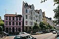
The partially four-lane Podbielskistraße leads as an arterial road from the city center towards the northeast. The district is characterized by town houses from the Wilhelminian era with sometimes very elaborate ornaments on facades and balconies as well as garden-architectural arrangements of green and multi-purpose areas from the late 19th century. Larger green spaces in the district are Welfenplatz and adjacent to the Eilenriede municipal forest, which is part of the Zoo district .
The northern part of the Lister Meile , which was established as a shopping street in the 1970s and is a pedestrian zone , runs through the district . The 1.08 km long Bödekerstraße is one of the busiest streets in Oststadt and connects the district with the List.
In 2004 the List celebrated its 700th anniversary. The oldest still existing half-timbered house is a former hermit's cottage on Waldstrasse. The social structure of the district has changed due to the growing attractiveness of large and lavishly designed old apartments.
Other places and institutions with the addition of List are:
- Lister Turm (leisure home, located in the Zoo district)
- Lister Platz (transport hub and subway station)
- Lister Bad (outdoor pool, located in the Vahrenheide district)
- IGS List ( Integrated Comprehensive School )
The Germania List sports club and the List canoeing community are known beyond the borders of Hanover .
The Pelikanviertel is located on Podbielskistraße between the Eilenriede city forest and the Mittelland Canal.

Weekly market on Moltkeplatz
Ferdinand-Wallbrecht-Strasse

Horse fountain

Podbielskistraße on Lister Platz

Frozen Mittelland Canal in the List
_IMG_1507.JPG)
_IMG_1514.JPG)
_IMG_1523.JPG)
_IMG_1544.JPG)

history


The current district of List was a farming village that already existed in the Middle Ages . The village of List was first mentioned in 1304, when Duke Otto the Strict of Braunschweig and Lüneburg donated 12 acres of farmland to a monastery in Hanover. The initially 4 farmsteads in the village of List were located near Hanover, which was then still insignificant . Later, the List settlement emerged as a clustered village on an area of 500 × 500 m between today's Höfestrasse, Wöhlerstrasse, Waldstrasse and Liebigstrasse. The place name List is probably based on its location near today's Hanover city forest Eilenriede . The term List used to mean a place on the edge of the forest in northern Germany .
Since the soil quality was not high, the situation in the village of List was rather poor. A few earlier farmhouses are still there today. In 1689 the village of List had 180 residents. At the Kurhannoverschen Landesaufnahme , a land survey from 1780, there were 26 farms of different sizes.
Urban settlement began around 1860 with the construction of the barracks around Welfenplatz . At the end of the 19th century, Hanover moved ever closer to the village with its residential developments and new factories. Some farming families (e.g. Kollenrodt and Kokemüller) achieved prosperity through the sale of land and built villas.
At the turn of the century, important companies settled in the area of what is now the List district, which at that time still partially belonged to Klein-Buchholz :
- Bahlsen biscuit factory
- Chemical factory de Haën
- Record factory Deutsche Grammophon
- Pelikan writing instrument factory
- Writing instrument factory Geha
- In 1872 Hermann Wohlenberg founded a mechanical workshop for the production of machine tools .
- The Constantin cigarette factory was established in 1888, was taken over by Reemtsma in 1928 and produced until 1971, when it was replaced by today's Reemtsma factory in Langenhagen .

Many large companies preferred the open space along Celler Chaussee, which has been called Podbielskistraße since 1904, as their location . The industrial settlements in Lister Feldmark triggered a demand for apartments and village life came to an end. In 1891 the List was incorporated into Hanover. At this time, residential construction began on a large scale. The Hanoverian urban development subsidy gave cheap loans and grants, especially for stucco and ornaments, four to five-story buildings and villas with magnificent facades in the Wilhelmine style were built. The closer the development of the Eilenriede came, the more representative it was designed. The housing shortage after the First World War also led to heavy building activity in the List in the 1920s. A characteristic residential complex was built on De-Haën-Platz , where the de Haën chemical factory was located until the turn of the century . The development of the square began in 1912, but due to the war, work could not be continued until 1925. The settlement Im Kreuzkampe was built north of Podbielskistraße in 1927 . The closed area comprises several streets, which were built uniformly. In 1906 the Protestant churches Markuskirche and Matthäuskirche were inaugurated, the Catholic St. Joseph's Church in a neo -Gothic style with great decor was built in 1911/12. In 1936 the now profaned Catholic St. Brother Konrad Church followed and in 1938 the Protestant Gethsemane Church.
During the Second World War, some of the last farmhouses in the village of List were destroyed in the air raids on Hanover .
Population development
| year | Residents | building |
|---|---|---|
| 1304 | 4th | |
| 1689 | 180 | 26th |
| 1823 | 286 | 38 |
| 1859 | 574 | 73 |
| 1891 | 3,200 | |
| 2011 | 43,584 |
Vahrenwald

The Vahrenwald district adjoins the List district in the west. One of Hanover's largest traffic axes, Vahrenwalder Strasse , runs right through it . It runs as a multi-lane arterial road from the city center to the north in the direction of Langenhagen to the A 2 . The headquarters of Continental AG and ContiTech AG are located in the southern area of the street .
The Werderstraße subway station is at the intersection of Vahrenwalder Straße with Werderstraße and Philipsbornstraße . It belongs to the B-route of the light rail . In the architectural design of the station, reference was made to the local Continental factory. The station is served by light rail lines 1 and 2.
To the north is Vahrenwalder Platz, which forms the center of the district. A little further north are the Vahrenwald leisure center , the Vahrenwald baths and the Evangelical Lutheran Vahrenwald church .
history


The village Vahrenwald was first documented in 1183 as Vorenwalde known, while Hannover 20 years before 1163 than Honovere was mentioned. According to another document from 1266, a preacher of the Hanoverian market church bequeathed part of his property in Vorenwalde to another church.
The village name Vahrenwald is probably derived from Vor-dem-Wolde (before the forest). At that time, the De grote Wald forest began on today's Kolonnenweg, stretching 30 km westwards at the height of today's Mittelland Canal to Neustadt am Rübenberge .
The village at that time was in the area of today's Rotermund-, Melanchthon- and Vahrenwalder Straße. A north-south military road from Hamburg via Hanover to Mainz passed the place early on . At that time it was called Stader Chaussee , today it is Vahrenwalder Straße. In the Middle Ages, pilgrims from Scandinavia traveled to the Holy City of Rome on it . To the north there were the large heather areas (barren land) of the Mecklenheide, on which the district of Vahrenheide later developed.
In the witch trial against Alheit Snur she was strangled on January 8, 1648 at the execution site of the Langenhagen Office between Langenhagen and Vahrenwald by the Hanoverian executioner Martin Vogt, after which her body was burned.
In 1689 Vahrenwald had 103 residents. In the middle of the 19th century there were 17 farms in Vahrenwald. By 1860 there were a total of 80 buildings and 308 residents. Only two of these buildings have survived to this day. In 1876 Vahrenwald already had almost 1,000 residents. At that time, the city of Hanover began to expand through the construction of barracks , including a barracks with the Prussian cavalry riding school , which later became the cavalry school or army riding school . Today there are still some red brick buildings on Dragonerstraße, which are in a well renovated condition. Among them is the Royal Riding Hall as one of what was once seven riding halls on the site. Following military use from 1950 to 1994, the barracks was home to the German Federal Railroad's (Kbw Hannover) vehicle depot. In the western area of the former barracks site directly at the Vahrenwalder road, the Vahrenwalder Freizeitheim emerged (about 1960) and the Vahrenwalder Bad of 1981. In the early 1990s, the inner region of the former barracks in a neighborhood park has been converted, the name Vahrenwalder Park bears.
Industrial companies soon followed the barracks, such as the Continental Gummiwerke in 1871. In 1880 a horse-drawn tram ran from Hanover via Vahrenwald to Langenhagen . In 1897 the line was electrified.
In 1891 it was incorporated into Hanover. After the First World War, Hannover-Vahrenwald Airport was built on the Vahrenwalder Heide . During the Second World War , Vahrenwald was a preferred target for allied bomber groups . Goals were u. a. the Continental works as an armaments factory, the railway line and the airport. The last major air raid on Hanover , which took place at the end of March 1945 about two weeks before the city was taken by American troops, caused great damage to the district. The airport was not put back into operation after the Second World War. Instead, the new district of Vahrenheide was created here .
District Council
In the local elections on September 11, 2016 , the SPD was again the strongest party in the district with 34.5% of the vote and Irma Walkling-Stehmann is the district mayor. The Greens became the second strongest party with 21.0% and are the deputy district mayor, Monica Plate. The Vahrenwald-List district council meets about eight times a year in public, mostly either in the Vahrenwald leisure center or the Lister Turm leisure center .
literature
- Karl-Heinz Estermann, Ernst Walther: Chronicle Vahrenwald (1183–1981). Hanover 1981.
- Joachim Schiele: List city. History and image of a district. Hanover 1983, ISBN 3-7716-1436-8 .
- Ernst Bohlius, Wolfgang Leonhardt : The List. 700 years of looking around the village and district history. Norderstedt 2004, ISBN 3-8334-0276-8 .
- Wolfgang Leonhardt: List and Vahrenwald, two defining districts of Hanover. Hamburg 2005, ISBN 3-8334-3333-7 .
See also
Web links
- City district portal Vahrenwald-List
- Structural data of the city districts and districts of Hanover as of 2020, a publication of the city of Hanover
- History of Vahrenwald
Individual evidence
- ^ District 2: Vahrenwald-List | District Councils | State capital Hanover | Political bodies | Politics | Living in the Hanover Region | Hannover.de | Home - hannover.de. Retrieved June 30, 2019 .
- ↑ Wolfgang Neß, Ilse Rüttgerodt-Riechmann, Gerd Weiß (ed.): Architectural monuments in Lower Saxony. 10.2. City of Hanover, part 2. Friedrich Vieweg and son, Braunschweig / Wiesbaden, 1985. ISBN 3-528-06208-8 . P. 27.
- ↑ Wolfgang Neß, Ilse Rüttgerodt-Riechmann, Gerd Weiß, Marianne Zehnpfenning (eds.): Architectural monuments in Lower Saxony. 10.2. City of Hanover, Part 1. Friedrich Vieweg and Son, Braunschweig / Wiesbaden, 1983. ISBN 3-528-06203-7 . Pp. 186-193.
- ^ HAZ District Gazette North of November 24, 2011
Coordinates: 52 ° 24 ' N , 9 ° 45' E