Lower Unstrut mountain and hill country
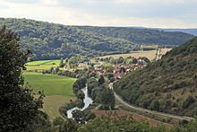
The Untere Unstrut mountain and hill country is a flat and step landscape along the Untere Unstrut and the Helme in the border area of Thuringia and Saxony-Anhalt , Germany . As part of the north-east framing of the Thuringian Basin, it represents a main unit of the main unit group Thuringian Basin (with edge plates) according to the manual of the natural spatial structure of Germany .
The landscape stands out from most of the neighboring landscapes due to the red sandstone . Well-known partial landscapes are the ridges of Finn , Schmücke and Hohe Schrecke .
Geographical location
The Lower Unstrut mountain and hill country extends over the Thuringian districts of Nordhausen , Kyffhäuser and Sömmerda as well as the Saxony-Anhalt district of Burgenland , Saale and Mansfeld-Südharz on both sides of the Lower Unstrut between Freyburg in the southeast, Heldrungen in the west and Querfurt in the east. A northern branch extends to the southern Harz region near Sangerhausen and from there north of the Golden Aue to Nordhausen .
Natural classification
The mountain and hill country occupying a total area of approx. 853 km² represents the main unit 488 within the natural spatial main unit group Thuringian Basin (with edge plates) .
A detailed breakdown is only available for the northernmost part of the landscape:
-
(for 47/48 Thuringian basins (with edge plates) )
- 488 Lower Unstrut - mountain and hill country
- 488.0 Nordhausener Plattenland
- 488.1 Sangerhausen hill country
- 488 Lower Unstrut - mountain and hill country
Adjacent natural spaces and landscapes are:
- Thuringian Basin in the southwest
- Helme and Unstrut lowlands ( Diamantene Aue ) in the mid-west
- Helmeniederung ( Goldene Aue ) in the south northwest
- South Harz Zechstein belt with the Lower Harz in the north
- Shell limestone landscapes of the Querfurter Platte in the east and the Unteren Unstrut Platte in the southeast
Classification according to TLUG
According to the purely inner- Thuringian classification, the natural areas of Thuringia of the Thuringian State Institute for Environment and Geology in Jena (TLUG), the parts located in Thuringia belong to the red sandstone hill countries :
- 2.1 North Thuringian red sandstone country
- 2.2 High scare - jewelry - fin
The Federal Agency for Nature Conservation (BfN) has created a slightly different structure and division according to the following landscape profiles:
- 48800 Northern Unstrut mountain and hill country (parts of the landscape south of the Helme on the Kyffhäuser are added)
- 48801 Southern Unstrut mountain and hill country
- 48400 North Thuringian hill country (for the part on the left of the Zorge up to the Thyra near Berga (Kyffhäuser) )
- 50202 Lower Unstruttal for the breakthrough valley between Memleben and Laucha
Partial landscapes
The natural area consists of different sub-landscapes:
- On the right the Unstrut from the plateau-like ridge of the Finne ( Wetzelshain : 370 m) and the more strongly structured foothills of the Schmücke ( Künzelsberg : 380.1 m) and Hohen Schrecke ( Beerberg : 362.7 m) to the north-west . The Finn continues in the southeast in the shell limestone of the Lower Unstrut plates between Eckartsberga and Bad Sulza to the Saale .
- The Unstrut forms a steep breakthrough valley between Memleben and Laucha , which continues southeast in the Muschelkalk to Freyburg .
- On the left the Unstrut from the less strongly structured slab of the Ziegelroda Forest (NN: 298.4 m) and its northern extension to Sangerhausen (leg shoe: 237.2 m).
- To the north of the Helmeniederung and south of the Harz Mountains, lying red sandstone country, which is strongly structured by the southern Harz runoff ( high head : 351.3 m).
Geology and nature
The main type of rock is the upper, middle and lower red sandstone. In the southwest, a step consisting of steeply upright shell limestone ( Finne fault ) forms a sharp boundary to the Thuringian Basin. At Roßleben there is a narrow strip of Zechstein and forms a small steep slope on the left slope to the Unstruttal. On the slabs, which slope slightly to the east, a layer of loess increases.
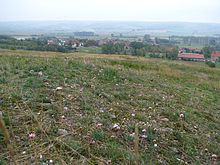
Large parts of the mountain ranges of Hohe Schrecke, Schmücke and Ziegelrodaer Forst are wooded (mixed deciduous forest). The eastern and northern parts are mainly used for agriculture. Large areas of the Lower Unstrut mountain and hill country are protected:
- Saale-Unstrut-Triasland nature park
- Harz / Saxony-Anhalt Nature Park
Individual evidence
- ↑ a b E. Meynen and J. Schmithüsen : Handbook of the natural spatial structure of Germany - Federal Institute for Regional Studies, Remagen / Bad Godesberg 1953-1962 (9 deliveries in 8 books, updated map 1: 1,000,000 with main units 1960)
- ↑ J. Spönemann: Geographical land survey: The natural spatial units on sheet 100 Halberstadt - Federal Institute for Regional Studies, Bad Godesberg 1970 → online map
- ↑ The single sheets to the south and east are no longer published
-
^ Walter Hiekel, Frank Fritzlar, Andreas Nöllert and Werner Westhus: The natural spaces of Thuringia . Ed .: Thuringian State Institute for Environment and Geology (TLUG), Thuringian Ministry for Agriculture, Nature Conservation and Environment . 2004, ISSN 0863-2448 . → Natural area map of Thuringia (TLUG) - PDF; 260 kB → Maps by district (TLUG)


