
Hauenstein-Ifenthal
| Hauenstein-Ifenthal | |
|---|---|
 |
|
| State : |
|
| Canton : |
|
| District : | Gösgen |
| BFS no. : | 2491 |
| Postal code : | 4633 |
| Coordinates : | 632 746 / 247683 |
| Height : | 675 m above sea level M. |
| Height range : | 561–973 m above sea level M. |
| Area : | 5.35 km² |
| Residents: | 315 (December 31, 2018) |
| Population density : | 59 inhabitants per km² |
| Website: | www.hauenstein-ifenthal.ch |
 The Ifenthaler Kirche St. Katharina seen from the west |
|
| Location of the municipality | |
  |
|
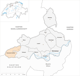
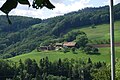
Hauenstein-Ifenthal is a municipality in the district of Gösgen in the canton of Solothurn in Switzerland . In addition to individual farms, the double community consists of two larger settlement parts: The village of Hauenstein is located at around 675 m above sea level. M. on a landscape terrace just below the culmination point of the pass at Unteren Hauenstein . Two kilometers west of it lies at around 700 m above sea level. M. the hamlet Ifenthal above the valley of the Grabenbach on the southern slope of the Ifleterberg . Between these two settlements, visible from afar, on the edge of the Jura slope above the Trimbach valley ( ditch ), the Ifenthal church with the patronage of St. Catherine is located .
The neighboring communities of Hauenstein-Ifenthal are Wisen , Trimbach , Wangen bei Olten , Rickenbach and Hägendorf in the canton of Solothurn and Eptingen and Läufelfingen in the canton of Basel-Landschaft .
geography
Hauenstein-Ifenthal is about four kilometers (as the crow flies) northwest of the city of Olten . The municipality extends to an average of 670 m above sea level. M. in the Solothurn chain Jura in a panoramic position over various hills on the south side of the Unterer Hauenstein pass crossing . It lies between the foothills of the Belchenflue in the west and the Wiesnerhöchi and Flüeli in the east. The area of the 5.3 square kilometer municipal area comprises a section of the heavily furrowed Solothurn chain of Jura, which has various striking rock faces and ridge here. In the south, the municipal boundary is on the edge of the Homberg.
In the western part of the municipality is the headwaters of the Dorfbach , which consists of several of the slopes of the Hornflue ( 967 m above sea level ; northern part of the Homberg ), the Challhöchi and the Ifleterberg (at 969 m above sea level, the highest elevation in Hauenstein -Ifenthal) flowing down small brooks. It first flows through the Ifental from west to east and then falls over several waterfalls into the ditch , a deep valley cut below Hauenstein belonging to Trimbach , and flows into the Aare a few kilometers after it emerges from the ditch into the open Olten basin .
The north-eastern part of the community is occupied by a plateau near Hauenstein, to which the slopes of the Lichtberg (up to 807 m above sea level ) connect in the east . The northern municipal boundary runs along the Challhöchi , the Ifleterberg and the Unteren Hauenstein and largely coincides with the watershed that separates the Aare river basin in the south from that of the Ergolz in the north along the main Jura ridge . In 1997, six percent of the municipal area was in settlements, 42 percent in forest and woodland, 51 percent in agriculture and a little less than one percent was unproductive land.
population
With 315 inhabitants (as of December 31, 2018), Hauenstein-Ifenthal is one of the small communities in the canton of Solothurn. 98.5% of the residents speak German, 1.1% speak Romansh and 0.4% speak Spanish (as of 2000). The population of Hauenstein-Ifenthal was 446 in 1850 and 295 in 1900. In the course of the 20th century, the population rose again to 380 people by 1930, and then decreased by almost 50% to 203 inhabitants by 1980 due to strong emigration. Since then there has been a slight increase in population again.
economy
Until the second half of the 20th century, Hauenstein-Ifenthal was predominantly an agricultural community. Even today, arable farming , fruit growing and animal husbandry have an important place in the income structure of the population. Further jobs are available in local small businesses and in the service sector, including in a timber construction company. Until 1996, limestone and Opalinus Clay were mined in a large quarry near Hauenstein . In the last few decades, thanks to its attractive location, Hauenstein in particular has developed more and more away from agriculture and into a residential community. Many residents are now commuters who mainly work in the Olten region.
traffic
The community is very well developed in terms of traffic. Hauenstein is on the main road from Olten via the Untere Hauenstein to Sissach , while Ifenthal is easily accessible from Hauenstein via a side street. Hauenstein and Ifenthal are connected to the public transport network by a bus line of the ( BOGG ), which serves the route from Olten to Wisen .
A side road leads over the Challhöchi pass and a footpath over the Homberglücke to Wangen bei Olten.
history
The municipality of Hauenstein-Ifenthal was settled very early, which has been proven by numerous finds from the Neolithic . During the Roman era , the lower Hauenstein pass crossing was used extensively and served as an important link between Augusta Raurica and the Central Plateau.
Hauenstein was first mentioned in a document in 1260 under the name Horwen ; The name Howenstein has been handed down from 1353 . The place name is derived from the Middle High German participle perfect gehouwen (hewn) and thus has the meaning of a pass path carved into the stone / rock. Ifenthal is first mentioned as Ifental as early as 1189 . The spellings Yffental (1201) and Ifendal (1225) appeared later . This name goes back to the Old High German personal name Iffo and means valley of Iffo .
Hauenstein and Ifenthal have been under the rule of the Counts of Frohburg since the Middle Ages . A ministerial family had its seat in Ifenthal, probably on the site of today's parish church. The pass road over the Untere Hauenstein has been expanded since around 1220, which is why Hauenstein developed into an important passport. After the Frohburger dynasty died out, the two villages came to the Counts of Nidau in 1367, to the Thiersteiners in 1375 as a Habsburg fief and to the Falkensteiners in 1418, who owned the Gösgen rule. For a long time, the borders in the area of the pass crossing were unclear and large parts of the area were temporarily part of Basel before they finally reached Solothurn through a settlement in 1506. Hauenstein and Ifenthal were now under the administration of the Bailiwick of Gösgen.
After the collapse of the Ancien Régime (1798), Hauenstein-Ifenthal belonged to the Solothurn administrative district during the Helvetic and from 1803 to the Gösgen district. With the opening of the Hauenstein tunnel on the Basel-Olten railway line in 1858, Hauenstein lost its importance as a passport, which resulted in a significant population decline.
During the First World War , the Hauenstein fortification, the most important defensive position of the Swiss army, was built in the Oberer and Unterer Hauenstein area.
Attractions
The Sankt-Katharina-Kapelle in Ifenthal was donated around 1260. In 1674 the building was enlarged and made a parish church. The church was given its current appearance during another renovation in 1935.
Hauenstein also had a pass chapel with the St. Nicholas Chapel , which gradually fell into disrepair from the 17th century. The ruins of the once magnificent Frohburg are located near Hauenstein .
photos
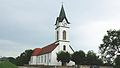
The Ifenthaler Church of St. Katharina

The Church of St. Catherine from the West
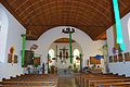
The Church of St. Catherine from the inside
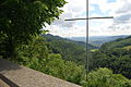
View from the Ifenthal cemetery into the Thal, in the background the Gösgen nuclear power plant
View from the Ifenthal cemetery to the hamlet of Wald

"Lions" Hauenstein

Schoolhouse Hauenstein


_128.JPG)


coat of arms
- A yellow lion walking to the right in red on a green map. The coat of arms is based on that of the Lords of Ifenthal
Web links
- Official website of the municipality of Hauenstein-Ifenthal
- Hans Brunner: Hauenstein-Ifenthal. In: Historical Lexicon of Switzerland .
Individual evidence
- ↑ Permanent and non-permanent resident population by year, canton, district, municipality, population type and gender (permanent resident population). In: bfs. admin.ch . Federal Statistical Office (FSO), August 31, 2019, accessed on December 22, 2019 .
Erlinsbach (SO) |
Hauenstein-Ifenthal |
Kienberg |
Lostorf |
Niedergösgen |
Obergösgen |
Pipe |
Stüsslingen |
Trimbach |
Winznau |
Wisen
Former communities: Niedererlinsbach | Obererlinsbach
Canton of Solothurn | Districts of the Canton of Solothurn | Municipalities of the Canton of Solothurn