Kęty
| Kęty | ||
|---|---|---|

|
|
|
| Basic data | ||
| State : | Poland | |
| Voivodeship : | Lesser Poland | |
| Powiat : | Oświęcimski | |
| Gmina : | Kęty | |
| Area : | 23.14 km² | |
| Geographic location : | 49 ° 53 ' N , 19 ° 13' E | |
| Height : | 275 m npm | |
| Residents : | 18,984 (Dec. 31, 2016) | |
| Postal code : | 32-650 | |
| Telephone code : | (+48) 33 | |
| License plate : | KOS | |
| Economy and Transport | ||
| Street : | DK52 Bielsko-Biała - Andrychów | |
| DW948 Oświęcim - Żywiec | ||
| Next international airport : | Krakow-Balice | |
| Katowice | ||
| Administration (as of 2012) | ||
| Mayor : | Tomasz Bąk | |
| Website : | www.kety.pl | |
Kęty ( German Kenty ; in the Middle Ages Libenwerde , Czech Kúty ) is a town in the powiat Oświęcimski of the Lesser Poland Voivodeship in Poland . It is the seat of the town-and-country municipality of the same name with more than 34,000 inhabitants.
geography
The city is located in the south of Poland on the right bank of the Soła with the Podlesie district and the Burgwald on the left bank. It is part of the Beskydy Euroregion . The state border with Slovakia runs about 40 kilometers south.
The neighboring towns are Nowa Wieś in the north, Witkowice in the northeast, Bulowice in the east, Bujaków , Kobiernice and Czaniec in the south, Kozy in the southwest, and Pisarzowice and Hecznarowice in the west.
history
In 1242 today's Kęty was first mentioned as "Canthi", later as Kantki (1277) Libinwerde (1368), Libenwerde (1391), Chanthy (1427), Kanthi alias Libenwerd (1429), Kenthi (1504), Kutty ( in Czech spelling, 1548) . In 1277 the place in the Duchy of Opole received city rights . From 1290 it was in the Duchy of Teschen and since 1315 in the Duchy of Auschwitz . In 1391 the town charter was confirmed according to Magdeburg law . The place name is influenced by the local Polish dialect, in which the name Kąty (compare kąt - corner, in the sense of a secluded place ) was pronounced as Kenty or Kęty . The German name Lieben + Werde is associated with the higher proportion, if not the majority, of German residents around 1400 (as documented by Peter Gleczer , Peter Honnig , Martin Schneider ) than it was probably part of the Bielitzer Sprachinsel . The name was no longer used after the Hussite Wars . In 1457 the Duchy of Auschwitz was bought by the Polish king.
A school was first reported in 1446. In 1564 Kęty was completely incorporated as the most populous place (over 1000 inhabitants) of the new Silesia District of the Krakow Voivodeship to the Kingdom of Poland , from 1569 the Polish-Lithuanian aristocratic republic . In 1623 and again in 1652 the plague raged in Kęty. During the Second Northern War , the city was heavily devastated in 1655. Another destruction took place two years later; a city fire destroyed large parts of the town.
During the first partition of Poland , Kęty came to Austria in 1772. In 1780 the construction of a new road from Vienna to Lemberg began (later the first Kaiser-Chaussee or Reichsstraße , also Wiener Postroute or Wiener Haupt Comercial Strasse , today DK52 in Kęty) and the next year the first route to Bochnia was opened. In 1780 the seat of the Zator district was moved to Kęty. From 1782 the city belonged to the Myslenice district (1819 with the seat in Wadowice ). After the abolition of patrimonial it became the seat of a judicial district in the Biała District . On June 28, 1797, there was the largest city fire in local history. In response, the construction of wooden houses was banned. During the Third Coalition War in 1805, Russian troops moved through Kęty in support of the Austrian army against Napoléon . On August 26, 1813, a flood destroyed parts of the city. In 1874 the volunteer fire brigade was established . The connection to the rail network took place in 1888.
At the end of the First World War , the place came to the re-established Poland . In September 1939 it was occupied by the German Wehrmacht . It then belonged to the district of Bielitz in the administrative district of Katowice in the province of Silesia (since 1941 province of Upper Silesia ). On January 28, 1945 troops of the 38th Army of the 4th Ukrainian Front reached the city. As a result, the place came to the People's Republic of Poland .
Religions
Two synagogues were built between 1871 and 1881. One was destroyed by the National Socialists in 1941 , the second is still today on Krakowska Street . In 1871 there were 66 Jews in the city; in 1880 the number had risen to 495. In 1921 there were 329 Jews in the city, in 1938 600. (see also: Jewish Cemetery (Kęty) )
In 1871 there were 13 Protestants, in 1880 there were 10.
Population development
The following is a graphic representation of the population development.

coat of arms
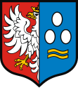
The coat of arms used today was officially introduced in 1793.
Culture and sights
Museums
- The Aleksander Kłosiński Museum is the city's historical museum. The namesake laid the foundation for the museum with his collection of old objects that were donated to the city after his death.
Buildings
- The Church of St. Margaret and St. Catherine (Kościół parafialny pw. Św. Małgorzaty i Katarzyny) was built in the 14th century and rebuilt in 1685 in the Baroque style.
- The St. Johannes Cantius Chapel (Kaplica św. Jana Kantego) is also a baroque building. It was built in 1648, and in 1715 it was rebuilt.
- The church and monastery of the Reformed Franciscans (Kościół i klasztor oo. Franciszkanów Reformatów) were built between 1705 and 1712.
- The convent of the Assembly of the Sisters of the Risen Lord (Klasztor Zgromadzenia Sióstr Zmartwychwstania Pańskiego) was built in the 19th century.
- The neo-Gothic Monastery of the Poor Clares of Perpetual Adoration (Klasztor Sióstr Klarysek od Wieczystej Adoracji) was built between 1890 and 1893.
local community
The urban-and-rural community (gmina miejsko-wiejska) Kęty has an area of 75.79 km² on which more than 34,000 people live. The municipality includes the city and six villages with school boards.
traffic
The state road 52 leads through Kęty from Bielsko-Biała , about 12 kilometers west, to Andrychów , about 8 kilometers east, and on to Głogoczów which is ten kilometers south of Kraków .
The nearest international airports are Katowice Airport , which is 40 kilometers north and John Paul II Airport Kraków-Balice around 45 kilometers northeast.
sons and daughters of the town

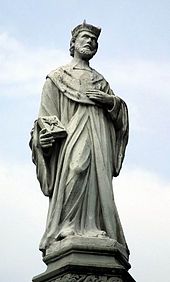
- John of Cracow (Polish Jan Kanty , 1390–1473), saint, priest of the diocese of Cracow , professor of theology at Jagiellonian University
- Antoni Hawełka (1840–1894), Polish merchant and restaurateur
- Aleksander Kłosiński (1892–1974), furrier and historian
- Paweł Graś (* 1964), politician, member of the Sejm
- Janusz Chwierut (* 1965), politician, member of the Sejm
Web links
- City website (Polish, English)
- Website of the Aleksander Kłosiński Museum with information on history and attractions (Polish, partly English)
Individual evidence
- ↑ Julian Zinkow: Oswiecim i okolice. Przewodnik monograficzny . Wydawnictwo "PLATAN", Oświęcim 1994, ISBN 83-7094-002-1 , p. 97 (Polish).
- ↑ a b J. Zinkow, 1994, p. 102
- ^ Tomasz Jurek (editor): Słownik Historyczno-Geograficzny Ziem Polskich w Średniowieczu. Edycja elektroniczna. Retrieved February 4, 2018 .
- ^ Website of the municipality, Miasto Kęty , accessed on April 11, 2009 ( WebCite ( Memento of April 11, 2009 on WebCite ))
- ↑ a b c d e f g h Muzeum im. Aleksandra Kłosińskiego w Kętach , accessed April 1, 2009 ( WebCite ( Memento from April 11, 2009 on WebCite ))
- ^ Krzysztof Rafał Prokop: Księstwa oświęcimskie i zatorskie wobec Korony Polskiej w latach 1438-1513. Dzieje polityczne . PAU , Kraków 2002, ISBN 83-8885731-2 , p. 151 (Polish).
- ↑ for 1340, 1529, 1609, 1662, 1667, 1775, 1810, 1843, 1851, 1867, 1871, 1880, 1900, 1918, 1921, 1931, 1938; Muzeum im. Aleksandra Kłosińskiego w Kętach ( WebCite ( Memento from April 11, 2009 on WebCite ))
- ↑ Główny Urząd Statystyczny, "LUDNOŚĆ - STAN I STRUKTURA W PRZEKROJU TERYTORIALNYM" ( Memento from May 15, 2011 in the Internet Archive ) as of June 30, 2010
- ^ Museum website, O Muzeum , accessed April 12, 2009 ( WebCite ( memento April 11, 2009 on WebCite ))


