Kolari
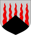
| coat of arms | map |
|---|---|

|

|
| Basic data | |
| State : |
|
| Landscape : | Lapland |
| Administrative community : | Fjell Lapland |
| Geographical location | 67 ° 19 ′ N , 23 ° 48 ′ E |
| Surface: | 2,617.77 km² |
| of which land area: | 2,558.68 km² |
| of which inland waterways: | 59.09 km² |
| Residents : | 3,834 (Dec 31, 2018) |
| Population density : | 1.5 inhabitants / km² |
| Municipality number : | 273 |
| Language (s) : | Finnish |
| Website : | kolari.fi |
Kolari [ ˈkɔlɑri ] is a municipality in the Finnish part of Lapland . It is located at the confluence of the Muonionjoki and Tornionjoki on the border with Sweden . Kolari is known for the ski resort on Ylläs -Fjell.
geography
Kolari is located in the west of the Lapland landscape in the Finnish part of the Tornedalen, 86 km north of the Arctic Circle . In the west, the rivers Muonionjoki and Tornionjoki form the state border with Sweden . Neighboring communities of Kolari are Muonio in the north, Kittilä in the northeast, Rovaniemi in the southeast, Pello in the south and Pajala on the Swedish side . The next larger town is the center of Pajala 30 km to the west, and it is 164 km to the city center of Rovaniemi, the largest city in Lapland. The distance to the capital Helsinki is 926 km.
With an area of 2618 km², Kolari is somewhat larger than Luxembourg , but with a population density of 1.5 inhabitants per square kilometer of land area, it is also very sparsely populated. A little over a third of the 3834 inhabitants (as of December 31, 2018) live in the church village ( Kirkonkylä ) of Kolari, which is located on the banks of the Muonionjoki. The rest of the population is spread over 15 villages in the municipality. The villages of Kolari are:
|
|
Kolari is located in the fells area of Northern Lapland. The highest mountain in the municipality is the 718 m high Yllästunturi , one of the most popular ski areas in Finland. The Äkäslompolo and Ylläsjärvi ski resorts are at its foot . Other fells in the municipality are Kesänkitunturi (517 m), Lainiotunturi (613 m), Kuertunturi (443 m), Pyhätunturi (441 m) and Kellostapuli (460 m).
By Finnish standards, Kolari has poor inland waterways: only 2% of the municipality is covered by water (the national average is 12%). The lakes in Kolari, such as Pasmajärvi, Aalisjärvi, Laukkujärvi, Vaattojärvi, Ylinen Sieppijärvi, Lompolojärvi, Venejärvi, Äkäslompolo and Pakajärvi are all quite small.
Kolari is home to one of 17 research forests of the Finnish Forest Research Institute. The Kolari research station was opened in 1964. The traditional and central task of the station is the research work on forest refinement . Today, however, the tracking of the tree line as an aid to climate research, which began in 1994, is the most important field of research. The Kolari station also includes the research forests in Kilpisjärvi and Laanila . The research area in Kolari today covers 7413 hectares, of which 2795 hectares consist of forest area. The majority of the area consists of fine sandy, often swampy ground.
history
Originally, the Kolari area was inhabited by semi-nomadic Sami who made their living from reindeer herding . The sedentary Finnish settlement of Kolaris came about during the inland colonization by settlers from Savo in the 16th century. The name Kolari goes back to the farmer Pekka Kolari from Rautalampi , who founded the first farm in the area around 1580; this name is derived from the Swedish kolare “ Köhler ” and not from the homonymous Finnish word kolari , “accident”.
Over time, the rural population of Kolari grew and the Sami were gradually assimilated by Finnish immigration or pushed northwards. During the time Finland was part of Sweden, Kolari was part of the Västerbotten countryside and belonged to the Pajala chapel in the Ylitornio parish . Even after Finland became a grand duchy under Russian rule in 1809 , when the rivers Muonionjoki and Tornionjoki were defined in the Fredrikshamn Treaty , Kolari's relations with Pajala continued until 1820. In 1856 Kolari became a chapel parish of Turtola (now Pello). A little later the place was raised to an independent parish, which was converted into a political municipality in 1867 as part of the reorganization of the municipal constitutions.
During the Second World War , during the Continuation War 1941–1944, like all of Northern Finland , Kolari belonged to the area of operations of the German Wehrmacht . After Finland had signed an armistice agreement with the Soviet Union in which it undertook to drive the German troops out of the country, the Finnish-German Lapland War began on September 15, 1944 . As in all of Lapland, the civilian population of Kolari was evacuated within a short time. The German troops began a controlled retreat using the scorched earth tactic , and on October 22, 1944, after a fierce battle, the Finnish army captured the village of Kolari, which had previously been burned by the Germans.
Since the Finnish economic crisis at the beginning of the 1990s, the population of Kolari has been constantly decreasing, as has been the case in all of Lapland due to the migration to the growth centers of the south. In 1986 the community still had over 5000 inhabitants, today there are only around 3800. There are considerable differences within Kolaris: While the villages in the northern part of the municipality were able to benefit from the ski resorts on Yllästunturi and their population has even increased, smaller ones have increased Villages like Nuottavaara partly halved the population within 15 years.
politics
As is generally the case in rural areas of northern Finland, the Center Party is the strongest political force in Kolari . In the local elections in 2008 it received 43.7% of the vote, in the local council, the highest decision-making body in local affairs, it has ten out of 21 MPs. The second strongest force is the Left Alliance , which, as in general, is disproportionately strong in Lapland. It won over a third of the votes and has seven seats on the local council. The Social Democrats and the National Collection Party , although belonging to the three major parties nationwide, only play a marginal role in Kolari, with election results around ten percent and two members each on the local council.
| Political party | 2008 election results | Seats |
|---|---|---|
| Center Party | 43.7% | 10 |
| Left alliance | 34.9% | 7th |
| Social democrats | 10.7% | 2 |
| National rally party | 10.6% | 2 |
Kolari maintains a town partnership with the Swedish neighboring municipality Pajala.
economy
Until the 1960s, forestry and dairy were the basis of the economy in Kolari. With the opening of an iron ore mine of the state-owned Rautaruukki group in Rautavaara, a limestone quarry and a cement works, extensive industrialization of the community began; In 1975 more than a fifth of the workforce worked in the industrial sector. After the iron ore mine and the cement works were closed at the end of the 1980s, Kolari was developed into a tourist center with substantial government subsidies.
Today, thanks to the skiing center on Yllästunturi, tourism has become the most important industry in Kolari. With around 185,000 overnight stays per year, Ylläs is the third largest in Finnish Lapland after Saariselkä and Levi . The main season is winter: 80% of the overnight stays are registered in the months of December to April. Around 40% of the visitors come from abroad, the largest group being the British, followed by Swiss and Germans. In summer, the nights by traveling to bridge the North Cape tourist the off-season, also try local organizers with hiking and mountain biking permanently to keep guests in the Ylläsregion. The operators of the ski sports center are planning to expand Ylläs further and to increase the number of beds from the current 18,000 to 50,000 by 2020.
traffic
The road network in Kolari is rather thin due to the low population density. The main artery is the state road 21 ( E8 ), which runs along the Swedish border from Tornio to Kilpisjärvi . It crosses the church village of Kolari and connects the place with Muonio in the north and Pello in the south. The main road 80 leads from Kolari to Kittilä. There is a border crossing point to Sweden near the church village, through which Pajala can be reached.
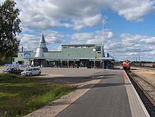
In 1964 Kolari was connected to the Finnish railway network with the completion of the single-track line to Kemi (220 km south). Kolari is the northernmost station on the Finnish railway network and serves both passenger and freight traffic. The station has a loading point for motorail trains . Until 2004, two lines led from Kolari station further north to the mines of Rautavaara and Äkäsjoki, but traffic on these has since been stopped. Another train station is located in the village of Sieppijärvi in the south of the municipality. The nearest airports are in Kittilä and on the Swedish side in Pajala.
Attractions
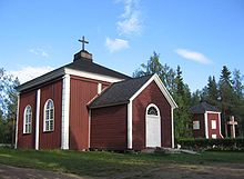
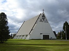
The listed old wooden church of Kolari on the river island Kolarinsaari in Muonionjoki, built between 1818 and 1819, is of cultural and historical value. It is an almost cube-shaped building with a tent roof and a lantern on top; the bell tower is free-standing. Today it is only used on special occasions. A modern functionalist building in the center of Kolari has served as the main church of the community since 1965 . There are also chapels in the villages of Sieppijärvi (1956) and Äkäslompolo (Laurentiuskapelle, 1999). The village ensemble of Venejärvi on the lake of the same name is also listed.
The actual "sights" of Kolaris are more likely to be found in nature. In the north of the municipality, Kolari is part of the Pallas-Yllästunturi National Park , the third largest national park in Finland. In addition to the up to 700 m high fells, the Pakasaivo lake, created from a glacier mill, the Äkkäslinkka and Kuerlinkat rapids, the Äkkässaivo canyon and the nature trails of Varkaankuru and Niesakero are of tourist interest. A special feature is the historical 11 km long stick dam between the villages of Kurtakko and Venejärvi, which was built in 1878 to ensure the mail and goods traffic to these remote settlements. It leads through the Teuravuoma-Kivijärvenvuoma moorland, one of the largest aapamoore in Finland. An area of 5788 hectares is now an internationally significant wetland area under the Natura 2000 system and is of particular interest to bird watchers .
A cable car with 4-seater gondolas was equipped with the world's first sauna gondola and a sauna in the mountain station next to it.
Sons and daughters
- Pertti Teurajärvi (* 1951), cross-country skier
- Suvi Teräsniska (* 1989), pop singer
Web links
Individual evidence
- ↑ Maanmittauslaitos (Finnish land surveying office): Suomen pinta-alat kunnittain January 1, 2010 . (PDF; 199 kB)
- ↑ Statistical Office Finland: Table 11ra - Key figures on population by region, 1990-2018
- ↑ a b Population figures as of December 31, 2005, website of the municipality: Väestökehitys osa-alueittain ( Memento from September 29, 2007 in the Internet Archive ) (Finnish)
- ↑ http://www.turisti-info.fi/n%C3%A4ht%C3%A4vyydet/%C3%A4k%C3%A4slompolo/2685/
- ↑ Finnish Institute for Forest Research: Historia ( Memento of the original from September 28, 2007 in the Internet Archive ) Info: The archive link has been inserted automatically and has not yet been checked. Please check the original and archive link according to the instructions and then remove this notice.
- ^ Finnish Institute for Forest Research: Kolarin tutkimusalue
- ↑ Matti Enbuske: Lapin asuttamisen historia . In: Ilmo Massa, Hanna Snellman (eds.) Lappi - Maa, kansat, kulttuurit , Suomalaisen Kirjallisuuden Seura, Helsinki 2003. Here p. 48.
- ↑ Website of the Kolari parish ( memento of the original from April 30, 2007 in the Internet Archive ) Info: The archive link has been inserted automatically and has not yet been checked. Please check the original and archive link according to the instructions and then remove this notice. (Finnish)
- ↑ Helsingin Sanomat: Lapin Sota 1944–1945 (Finnish)
- ↑ Finnish Statistical Office ( Memento of the original dated December 16, 2007 in the Internet Archive ) Info: The archive link was inserted automatically and has not yet been checked. Please check the original and archive link according to the instructions and then remove this notice.
- ↑ Finnish Ministry of Justice: Result of the 2008 local elections
- ↑ Heikki Jussila and Jari Järviluoma: Extracting local resources: The tourism route to development in Kolari, Lapland, Finland. In: Cecily Neil and Markku Tykkyläinen (eds.): Local Economic Development: a geographical comparison of rural community restructuring . United Nations University Press, New York 1998. pp. 269-289.
- ↑ Status: 2003, Lapin liitto: Tourism in Finland and Lapland (English), p. 76.
- ↑ Lapin liitto: Tourism in Finland and Lapland (English), p. 86.
- ↑ Lapin liitto: Tourism in Finland and Lapland (English), p. 81.
- ↑ Heikki Hellman: Tunturipurojen raiskausta . In: Helsingin Sanomien kuukausiliite , October 2006. Here p. 76.
- ↑ Information motorail trains Finland ( Memento from February 3, 2009 in the Internet Archive )
- ↑ Finnish Monument Protection Register : Kolarin kirkonseutu (Finnish)
- ↑ Finnish Monument Protection Register : Venejärven kylä (Finnish)
- ↑ site of the village Kurtakko ( Memento of the original on 30 September 2007 at the Internet Archive ) Info: The archive link is automatically inserted and not yet tested. Please check the original and archive link according to the instructions and then remove this notice. (English)
- ↑ ymparisto.fi ( Memento of the original from September 30, 2007 in the Internet Archive ) Info: The archive link was inserted automatically and has not yet been checked. Please check the original and archive link according to the instructions and then remove this notice. (English)
- ↑ http://www.news.at/a/gondeln-extrem-bergbahn-innovationen/2424227 Bergbahn innovativ, extreme gondolas: Sauna gondola in Ylläs (Finland), News.at, November 15, 2012 (Fig. 6– 8/18)


