Kunashir
| Kunashir | |
|---|---|
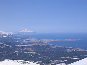
| View of Kunashir and the town of Yuzhno-Kurilsk | |
| Waters | Pacific Ocean |
| Archipelago | Kuril Islands |
| Geographical location | 44 ° 7 ′ N , 145 ° 51 ′ E |
| length | 123 km |
| width | 30 km |
| surface | 1 489.27 km² |
| Highest elevation |
Tjatja 1819 m |
| main place | Yuzhno-Kurilsk |
Kunashir ( Russian Кунашир ; Japanese : 国 後 島 , Kunashiri -tō ) is an island in the Kuril archipelago. It belongs to Russia , but is claimed by Japan as part of the sub-prefecture of Nemuro , Hokkaidō .
etymology
The name comes from the Ainu , probably from kina-sir ( キ ナ シ ㇼ ) meaning "grass island", or from kunne-sir ( ク ン ネ シ ㇼ ) for "black island".
geography
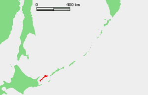
Kunashir lies in a north-easterly direction off the coast of Hokkaidō , immediately at the southern end of the Kuril island chain, between the Strait of Kunashir in the south and the Jekaterina Strait in the north. With an area of around 1489.27 km², it is one of the larger islands in the archipelago. Kunashir is about 123 km long, with a width of 4 to 30 km.
The island is formed by four volcanoes that were once separate islands, but have now connected through low-lying areas with lakes and thermal springs . The four volcanoes are still active: Tjatja (1819 m), Rurui in the Dokuchayev ridge, Mendeleev and Golownin . The bottom of the island is made up of volcanic and crystalline rock . The climate is of the monsoon type.
The vegetation consists mainly of spruce , pine , fir and mixed forest of deciduous deciduous trees with lianas and Kuril bamboo as undergrowth . The mountains are covered with bushes of birch and Siberian dwarf pine or herbs or are bare rock.
History and politics
Kunashir became Japanese territory by the Treaty of Shimoda in 1855 . In 1945 the island was occupied by Soviet troops . Since 1946 it has belonged to their national territory according to the Soviet and, since 1991, Russian view. As part of the Southern Kuril Islands, Kunashir is the subject of the Kuril conflict : sovereignty over Kunashir is claimed by Japan.
economy
The economy of Kunashir, which administratively belongs to Sakhalin Oblast , is characterized by fishing and the fishing industry. The island has a port at the Yuzhno-Kurilsk settlement , the seat of the Yuzhno-Kurilsk district and the most important settlement on the island.
Web links
- Unofficial web portal of the island of Kunashir (Russian)
- Project of an eco-settlement on Kunashir (Russian)
Individual evidence
- ↑ ア イ ヌ 語 地名 リ ス ト . Hokkaido Prefecture, p. 45 , accessed April 28, 2011 (Japanese).
- ↑ Kazumi Satō: 知 床 地名 行 . July 4, 1982, Retrieved April 28, 2011 (Japanese).
- ↑ 島 面積 . (PDF; 136 kB) (No longer available online.) Kokudo Chiriin , October 1, 2015, archived from the original on June 15, 2016 ; Retrieved July 30, 2016 (Japanese). Info: The archive link was inserted automatically and has not yet been checked. Please check the original and archive link according to the instructions and then remove this notice.


