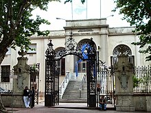
Figurita
Figurita , also La Figurita , is a district ( barrio ) of the Uruguayan capital Montevideo .
Location and geography
It is located north of the city center in the central north of the Montevideo department . Figurita borders La Comercial and Villa Muñoz - Retiro in the south . To the west are the districts of Reducto and Atahualpa , while to the north Brazo Oriental and to the east Jacinto Vera .
The area of the district is enclosed, starting from the southwest in a clockwise direction, by the borderline formed by the following streets: Avenida General Flores , Avenida General Garibaldi , Marsella , Enrique Martinez , Carabelas , Bulevar Artigas , Lorenzo Fernandez , Avenida General Flores , Dr. Luis Melinan Lafinur , Lorenzo Fernandez , Caraguta , Juan Paullier , Itapebi , Dr. Joaquin Requena , Colorado , Cufre , Isla de Gorriti, and Concepcion Arenal .
The area of Figurita is the municipality C assigned.
description
In Figurita there is the Parroquia Nuestra Señora de los Dolores and the Hospital Español "Juan José Crottogini" .
Individual evidence
- ↑ Map of the Uruguayan National Statistics Institute for the classification of the barrios of Montevideo (PDF; 1.6 MB)
Coordinates: 34 ° 53 ′ S , 56 ° 11 ′ W


