
Warehouses
| Warehouses | ||
|---|---|---|
 The camps from west (left) to east (right) |
||
| height | 866 m above sea level M. | |
| location | Canton of Zurich and Canton of Aargau , Switzerland | |
| Mountains | law | |
| Dominance | 16.4 km → Uetliberg | |
| Notch height | 425 m ↓ west of Chatzensee | |
| Coordinates | 671999 / 259442 | |
|
||
| Type | Folded Jurassic | |
| rock | Malmkalk | |
 Aerial view of the wooded ridge (1963) |
||

Die Lägern (more rarely: der Lägern, also Lägeren , in dialect: d Lägere and de Lägere ) is a ten kilometer long, narrow ridge between Baden and Dielsdorf in the Swiss cantons of Aargau and Zurich .
geology

The Lägern is the easternmost branch of the Folded Jura and runs in an east-west direction. The ridge, which has come to a point , was unfolded around 9 to 4 million years ago in the late Tertiary era by thrust from the Alps to the northwest. It consists mainly of Malmkalk , which is exposed near Baden and on the ridge. Apart from that, the whole mountain is forested.

The rock layers were pushed north by the tectonics, which resulted in folding, which in places turned into thrust. A large part of the unfolded material was removed again over time by erosion, as a result of which anticlinal valleys formed, e.g. B. the valley in which the town of Ennetbaden is located. The Lägern itself largely only represents the southern part of the original anticline, remnants of the northern counterpart can still be found in the Geissberg north of Ennetbaden and on the Steinbuck near Ehrendingen. As a result of the erosion, the edges of the slabs are exposed on the north slope and on the ridge of the Lägern (and correspondingly on the south slope e.g. of the Geissberg). On the Geissberg, the plates are practically vertical or even partially "overturned" to the north due to the thrust (see picture).
Fossils can be found in the warehouses . The most common finds include ammonites from the Jurassic period . On the northern slope of the Lägern, in Oberehrendingen , gypsum has been mined in the so-called Gipsgruebe ▼ (see illustration) since the Middle Ages . From 1894 to 1902 the material was processed by the Lägern cement factory . In the pit that was left open, the folds of the rock layers that are characteristic of the Jura can be seen particularly well on the demolition. Limestone is still quarried in Steinmaur near Dielsdorf today .
The geologist Casimir Mösch contributed significantly to the research of the Aargau Jura - the camps were his preferred research area.
Attractions
The highest points from west to east are the point 805 m, also called Wettingerhorn ▼ , the Burghorn (859 m) ▼ . Under their saddle is the « Walhalla » ▼ cave , which four young people from Wettinger explored and expanded for the first time in their free time in 1921. After that, from 1930 to the Second World War, various youth organizations continued to expand the cave.
The highest elevation at the Alt-Lägern ruins (866 m) ▼ and the Hochwacht (853 m) ▼ . There is a first-order fixed point on the Hochwacht (originally a triangulation point ).
The view from the vantage point on the Burghorn extends to the south from Säntis in the Appenzell Alps over the Glarus Alps with the Tödi , the Urner Alps with the Titlis to the four-thousand-meter peaks of the Bernese Alps . In the foreground you can make out some striking points in the Central Plateau and the foothills of the Alps, e.g. B. Lake Zurich with Uetliberg and the mountains around Lake Lucerne with Rigi and Pilatus . To the north there is a view of the Black Forest with the Feldberg as the highest elevation, the Randen and, to the east, the volcanic chimneys of the Hegau .
An excursion restaurant was built on the Hochwacht in 1895. In the immediate vicinity there is a large, south-facing viewing platform that allows a sweeping view of the Alps. Compared to the Burghorn, you also have a clear view to the east of Zurich Airport and the Säntis .
To the west of the Hochwacht are the ruins of Alt-Lägern . It was built by the Barons von Regensberg and probably destroyed in 1267. The rectangular surrounding wall 20 × 67 m and the well, which was repaired in 1982, are still visible today. The high watch was part of the military alarm system created by the Zurich government in the 17th century. It connected several Hochwachten among others on the Uetliberg and the Irchel .
Newer buildings on the Lägern are the restaurant ▼ built in Wettingen on the Schartenfels in 1894 in a castle-like facility and the Radom ▼ on the Hochwacht, which covers a secondary radar from the Swiss air traffic control system Skyguide . The radar was renewed in 2006 and 2007, after which the two radio transmitters Lägern West ▼ and Lägern Ost ▼ were renewed. The medieval country town of Regensberg with Castle ▼ lies on a rock spur near Dielsdorf . Until the summer of 2016, there was a measuring station ▼ of the NABEL (National Monitoring Network for Air Pollutants in Switzerland) on the southern slope of the Lägern above Wettingen .
The most important mammoth finds in Switzerland were made in Niederweningen at the northern foot of the Lägern . Exhibits can be viewed in the Mammoth Museum Niederweningen ▼ .
Höhenweg
A Höhenweg, a section of the Jurahöhenweg, runs between Baden and Dielsdorf .
After Schartenfels Castle, the path splits. One path runs directly on the ridge and is signposted as a white-red-white mountain path (difficulty level T3 ). The path is very narrow and exposed in places and requires surefootedness and a head for heights. Hikers have also died fatally on this route. Due to this fact, the Aargauer Wanderwege association , which is responsible for the maintenance of the paths, set up corresponding information boards at the access roads in May 2013.
The normal route runs north of the ridge . To the east of the Wettingerhorn, the paths unite on the ridge. From there, the path runs along the ridge over the Burghorn and the Alt-Lägern ruins to the Hochwacht ( T2 ).
Planet path
A planet path begins at the Linden car park in Regensberg and leads over the Hochwacht to the Burghorn. The model of the solar system is on a scale of 1: 1 billion. The path runs from planet earth on the high path towards the west.
Picture gallery

Lägerngrat
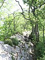
Rough path directly on the Lägern ridge

Warning sign at the entrance to the Lägern-Gratweg

Radome of the Swiss air traffic control Skyguide

View from the south near Wettingen on the lager

Alpine panorama from the Burghorn
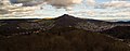
View of the Lägerngrat from the west, Ennetbaden on the left, Wettingen on the right

Lägern from the east, seen from the Neeracherried .

Lägern Hochwacht in July 1964. The air traffic control radar did not have a radome at that time


literature
- Rolf Meier and Bruno Meier (eds.): The Lägern - a tightrope walk: landscape and culture of a border mountain. Verlag hier + now, Baden 2003, ISBN 3-906419-67-3 .
- Hans Burger: Neujahrsblatt Ennetbaden 2013 - The subsoil of Ennetbaden. Published by the municipality of Ennetbaden.
Individual evidence
- ↑ City of Baden: Geo path ( Memento of the original from May 1, 2016 in the Internet Archive ) Info: The archive link was inserted automatically and has not yet been checked. Please check the original and archive link according to the instructions and then remove this notice. (PDF; 1 MB), accessed on February 1, 2014.
- ^ Item 14: cement factory. (No longer available online.) In: Ehrendinger Runde. Ehrendingen community, archived from the original on December 26, 2017 ; Retrieved December 25, 2017 . Info: The archive link was inserted automatically and has not yet been checked. Please check the original and archive link according to the instructions and then remove this notice.
- ↑ Eugen Meier: The Walhalla. Badener Neujahrsblätter, 1999, accessed on March 21, 2020 .
- ↑ Tages-Anzeiger, June 21, 2008: The Lägern now has a planetary path. (PDF file; 373 kB)