Lehndorf (Braunschweig)
|
Lehndorf
City of Braunschweig
|
|
|---|---|
| Coordinates: 52 ° 16 ′ 30 ″ N , 10 ° 28 ′ 44 ″ E | |
| Height : | 95 m above sea level NHN |
| Residents : | 6233 (December 31, 2015) |
| Incorporation : | 1934 |
| Postal code : | 38116 |
| Area code : | 0531 |
|
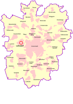
Location of Lehndorf in Braunschweig
|
|
|
Roggenmühle Lehndorf from 1912 (photo from 2006)
|
|
Lehndorf is a district of Braunschweig and is located in the city district 321 - Lehndorf-Watenbüttel .
Alt-Lehndorf
|
|
|
|---|---|
| The first cartographic representation of Lehndorf in the official atlas of the Principality of Braunschweig-Wolfenbüttel by Gottfried Mascop , 1574. |
Alt-Lehndorf is a district of Lehndorf, it has 1300 inhabitants and forms the statistical district 29 of the city of Braunschweig.
- history
Alt-Lehndorf is the oldest part of Lehndorf and used to be an independent village. Lehndorf was first mentioned in a document in 1067 as "Lentorpe" on the Braunschweig – Hildesheim road. The separation of Alt-Lehndorf and Lehndorf settlement did not take place until the settlement was built in 1934. The two parts of Lehndorf are separated from one another by Bundesstrasse 1 , Hannoversche Strasse.
Lehndorf settlement
The Lehndorf settlement is the larger and northern part of the Braunschweig district of Lehndorf, which is located in the north-west of the city. Population 4933.
history
As early as the 1920s, there were considerations to create new apartments for people living in z. Some of them lived in unworthy quarters in the Braunschweig city center (especially on the Radeklint ). In 1921, the Braunschweig architecture professor Herman Flesche presented plans for settlements in Lehndorf, Mascherode , for the so-called Nibelungen settlement and the garden city . However, these plans could not be implemented because the Reich Settlement Act prohibited expropriation from agricultural property.
After the seizure of power in 1933, the legal situation was changed and the settlement plans were then implemented quickly. Already on March 21, 1934 the "community settlement Lehndorf" was started because apartments were urgently needed for the employees of MIAG Mühlenbau und Industrie AG and the German Research Institute for Aviation (DFL, later LFA: "Aviation Research Institute Hermann Göring"). Today, their northwestern properties are used by the Johann Heinrich von Thünen Institute (vTI) and the Physikalisch-Technische Bundesanstalt (PTB) . By 1936, 2,600 residential units were built. The often socially weaker buyers of the home plots, including war invalids from the First World War , had the opportunity, according to the Reichsheimstättengesetz , to keep building costs low through self-help.
Two-story tenement houses with six apartments each were built along the main street, Saarstrasse, which connects the settlement to the city center and led to what was then DFL / LFA; In the first of these blocks, former convicts were to be rehabilitated. In the streets behind it, one- and two-family houses with garden areas and stables were built for self-sufficiency. More spacious single-family houses for academics were built on the edge of the settlement.
Many streets and squares (such as the central "Saarplatz") were named after places in the Saar area after the reintegration of the Saar area by referendum on January 13, 1935. In accordance with the Germanization at the time, an avenue named after Saarlouis was still called Saarlauternstraße until the early 1980s, while the place had had its old name again since 1945. Between 1950 and 1952, the Lauterbacher Strasse in the settlement was renamed Koblenzer Strasse . Since Lauterbach (Warndt) in the Saarland , which gave the name, does not reveal any specific NS pollution even reaching the problem of the name Saarlautern , the motive for the change can be assumed to be that the impression should be avoided that the street was after that which was responsible for Braunschweig Gauleiter Hartmann Lauterbacher named.
Churches
Wichernkirche
In July 1935, Adolf Hitler paid a brief visit to the “model settlement”. During this visit he had the plans to have a church in the center of the settlement changed. The "Aufbauhaus" on Saarplatz is still the dominant center of the settlement today. It contained an elementary school and all the authorities necessary for the settlement; Today the Lehndorf elementary school, a kindergarten, the “Turm” youth club and a police station are located there. The church, which had been designed by the Munich architect Gustav Gsaenger , was pushed into a side street (Sulzbacher Straße 41). It was not allowed to carry a tower and could only be inaugurated on October 6, 1940. At this point in time, the settlement was essentially complete.
Holy Spirit Church
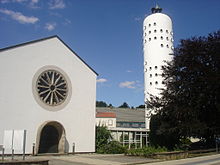
In 1952 the Heilig-Geist-Kirche was opened on the St.-Ingbert-Str. Built in 90 after the loss of the German eastern territories and the resulting influx of Catholics in Braunschweig-Lehndorf had skyrocketed. The construction was carried out according to plans by the Brunswick architect Fritz Hauk. Dominikus Böhm (Cologne) designed the colorful glazing, which is well worth seeing; the decoration was made with sculptures and bronze sculptures by the Cologne artist Toni Zenz , who stylistically follows the tradition of Ernst Barlach and Käthe Kollwitz . A tower was later added to the church and a wood-carved Swabian Madonna figure from the 15th century was acquired.
Kreuzkirche
The cruciform church in the district of Alt-Lehndorf (Große Straße 27) dates in part from the 12th century. It was expanded in the 19th century by a building worth seeing, which has historicizing elements and Art Nouveau elements.
Personalities
- The German painter Walther Hoeck (1885–1956) lived in Lehndorf-Siedlung .
- The architect and local history researcher Gunnhild Ruben (1926–2012) was Lehndorf's local home nurse for 24 years.
coat of arms
The coat of arms shows a centrally arranged, tapering, silver cross, which is surrounded by four beech leaves on a green shield.
The green background color symbolizes the numerous green spaces in this part of the city. The beech leaves stand for the Pawel wood and the cross indicates the centuries-old connection with the Kreuzkirche in Alt-Lehndorf and the Kreuzkloster . The tapering of the cross is based on the Saarland coat of arms crosses and creates an ideal relationship with this federal state, which is also expressed here by numerous street or square names.
The coat of arms was designed by Arnold Rabbow and accepted as the coat of arms by the Lehndorfer associations on June 6, 1980.
literature
- Helmut Weihsmann : Building under the swastika. Architecture of doom. Promedia Druck- und Verlagsgesellschaft, Vienna 1998, ISBN 3-85371-113-8 , pp. 313-314.
Web links
Individual evidence
- ↑ a b c population statistics on braunschweig.de
- ↑ Compare Address Book 1950 , III. Department, street directory and address book 1952 , III. Department, street directory
- ↑ [1] , [2]
- ^ Arnold Rabbow: New Braunschweigisches Wappenbuch. Braunschweiger Zeitungsverlag, Meyer Verlag, Braunschweig 2003, ISBN 3-926701-59-5 , p. 21.


