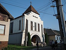
Magnezitovce
| Magnezitovce | ||
|---|---|---|
| coat of arms | map | |

|
|
|
| Basic data | ||
| State : | Slovakia | |
| Kraj : | Banskobystrický kraj | |
| Okres : | Revúca | |
| Region : | Gemer | |
| Area : | 15.176 km² | |
| Residents : | 454 (Dec. 31, 2019) | |
| Population density : | 30 inhabitants per km² | |
| Height : | 353 m nm | |
| Postal code : | 049 16 ( Jelšava Post Office ) | |
| Telephone code : | 0 58 | |
| Geographic location : | 48 ° 40 ′ N , 20 ° 14 ′ E | |
| License plate : | RA | |
| Kód obce : | 525944 | |
| structure | ||
| Community type : | local community | |
| Structure of the municipality: | 2 parts of the community | |
| Administration (as of November 2018) | ||
| Mayor : | Milan Pršebica | |
| Address: | Obecný úrad Magnezitovce č. 59 049 16 Jelšava |
|
| Website: | www.magnezitovce.ocu.sk | |
| Statistics information on statistics.sk | ||
Magnezitovce is a municipality in the center of Slovakia with 454 inhabitants (as of December 31, 2019), which belongs to the Okres Revúca , a district of the Banskobystrický kraj and is located in the traditional Gemer landscape .
geography
The village is located in the southeastern part of the Slovak Ore Mountains in the valley of the Muráň river , in a side valley below the Ostrý vrch mountain ( 870 m nm ). Magnesite deposits can be found southeast of Mníšany . The center of the village lies at an altitude of 353 m nm and is six kilometers from Jelšava and 12 kilometers from Revúca .
Administratively, the municipality is divided into the municipal parts Kopráš and Mníšany .
Neighboring municipalities are Čierna Lehota and Slavošovce in the north, Rochovce in the northeast, Jelšava in the east and south and Chyžné in the west.
history
The present municipality was created in 1960 through the merger of the places Kopráš (Hungarian Korpás - until 1907 Koprás ) and Mníšany (Hungarian Baráttelke - until 1907 Mnisány ).
Mníšany was mentioned in writing for the first time in 1427 as Monorethe , was at that time near a monastery and had 20 porta in the same year . Most of the inhabitants were then employed in gold, silver and copper mines. In the 15th century the place was further settled as part of the Wallachian colonization and in the 16th century belonged to the estate of the Muráň Castle . In 1828 there were 43 houses and 402 inhabitants who were employed in agriculture, mining (magnesite) and as workers in the surrounding companies.
Kopráš was established at the beginning of the 16th century under Wallachian law and was first mentioned in writing in 1551. The village belonged to the estate of the Muráň castle. In 1828 there were 26 houses and 186 inhabitants who were employed in forestry, charcoal burning and sheep farming.
Until 1918, the places in Gemer and Kleinhont counties belonged to the Kingdom of Hungary and then came to Czechoslovakia and now Slovakia. During the first Slovak Republic , the residents of both places worked on the construction of the Chyžnianská Voda – Slavošovce railway line (part of the Gemerer connecting railways ), which should reconnect valleys that were cut off after the First Vienna Arbitration with the rest of Slovakia. However, this project was never completed.
Today economic life is largely determined by the magnesite mine and the neighboring magnesite factory in Jelšava.
population
According to the 2011 census, there were 464 inhabitants in Magnezitovce, 459 of whom were Slovaks and one Roma and one Czech. Three residents made no statement. 119 residents belonged to the Evangelical Church AB, 82 residents to the Roman Catholic Church, six residents to the Reformed Church, five residents to the Greek Catholic Church, three residents to the Evangelical Methodist Church and one resident to the Jehovah's Witnesses. 218 inhabitants were without a denomination and the denomination of 30 inhabitants was not determined.
Results after the 2001 census (435 inhabitants):
|
By ethnicity:
|
By denomination:
|
Buildings
- Bell tower in the classical style from the 19th century
- Structures of the unfinished railway line, including the Kopráš viaduct (length 120 m), the Koprášsky tunnel (425 m) and the Slavošovský tunnel (2,400 m)
Individual evidence
- ↑ 2011 census by ethnicity (English)
- ↑ Census 2011 after confession (English) ( Memento of 12 November 2013, Internet Archive )
Web links
- Entry on e-obce.sk (Slovak)


