Čierna Lehota (Rožňava)
| Čierna Lehota | ||
|---|---|---|
| coat of arms | map | |

|
|
|
| Basic data | ||
| State : | Slovakia | |
| Kraj : | Košický kraj | |
| Okres : | Rožňava | |
| Region : | Gemer | |
| Area : | 31.873 km² | |
| Residents : | 640 (Dec. 31, 2019) | |
| Population density : | 20 inhabitants per km² | |
| Height : | 525 m nm | |
| Postal code : | 049 36 ( Slavošovce post office ) | |
| Telephone code : | 0 58 | |
| Geographic location : | 48 ° 43 ' N , 20 ° 15' E | |
| License plate : | RV | |
| Kód obce : | 525596 | |
| structure | ||
| Community type : | local community | |
| Administration (as of November 2018) | ||
| Mayor : | Iveta Potočná | |
| Address: | Obecný úrad Čierna Lehota č. 68 049 36 Slavošovce |
|
| Website: | www.obecciernalehota.sk | |
| Statistics information on statistics.sk | ||
Čierna Lehota (Hungarian Szabados - until 1907 Feketelehota ) is a municipality in the east of Slovakia with 640 inhabitants (December 31, 2019), which for Okres Rožňava of, part kraj Košický heard.
geography
The municipality is located in the southeastern part of the Slovak Ore Mountains , more precisely in the Stolické vrchy Mountains , at the upper end of the valley Štítnická dolina , below the mountains Stolica ( 1476 m nm ) and Kohút ( 1409 m nm ). The Štítnik flows through Čierna Lehota, receiving the Lehotský potok on the left and several tributaries on the right. The center of the village is located 25 kilometers from Rožňava at an altitude of 525 meters .
Neighboring municipalities are Rejdová in the north, Slavošovce in the east and south, Magnezitovce and Chyžné in the southwest and Muránska Zdychava in the west.
history
The place was first mentioned in writing in 1551 as Lehota , but it was established in the 15th century under Wallachian law. Other traditional names include Ober Lehota (1569), Feketelehota (1601) and Cžerna Lehota (1773). The village was initially owned by the Bebek family from Štítnik , later by the Andrássy family and administered by inheritors. Between 1709-10, 450 people were killed in a plague epidemic. In 1828 there were 108 houses and 931 inhabitants who were employed as shepherds, lumberjacks, shindlers and weavers, and from the 19th century they also worked in the nearby paper mill in Slavošovce.
Until 1918/1919, the place in Gemer and Kleinhont counties belonged to the Kingdom of Hungary and then came to Czechoslovakia or now Slovakia.
population
According to the 2011 census, there were 666 residents in Čierna Lehota, including 622 Slovaks , nine Magyars , five Roma , three Czechs , two Poles and one Moravian . One resident indicated a different ethnic group and 23 residents gave no information about the ethnic group .
268 residents committed themselves to the Evangelical Church AB, 61 residents to the Roman Catholic Church, 10 residents to the Greek Catholic Church, five residents to the Evangelical Methodist Church and three residents to the Reformed Church. 237 residents had no denomination and 82 residents had no denomination.
Buildings and monuments
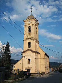
- Protestant church in baroque-classicist style from 1774
Individual evidence
- ↑ Slovenské slovníky: názvy obcí Slovenskej republiky (Majtán 1998)
- ↑ Results of the 2011 census (Slovak)
Web links
- Entry on e-obce.sk (Slovak)


