Jovice
| Jovice Jólész |
||
|---|---|---|
| coat of arms | map | |

|
|
|
| Basic data | ||
| State : | Slovakia | |
| Kraj : | Košický kraj | |
| Okres : | Rožňava | |
| Region : | Gemer | |
| Area : | 10.076 km² | |
| Residents : | 744 (Dec. 31, 2019) | |
| Population density : | 74 inhabitants per km² | |
| Height : | 280 m nm | |
| Postal code : | 049 45 (Post Office Krásnohorská Dlhá Lúka ) | |
| Telephone code : | 0 58 | |
| Geographic location : | 48 ° 38 ' N , 20 ° 33' E | |
| License plate : | RV | |
| Kód obce : | 560049 | |
| structure | ||
| Community type : | local community | |
| Administration (as of November 2018) | ||
| Mayor : | Ildikó Lukacsová | |
| Address: | Obecný úrad Jovice Hlavná 50 049 45 Krásnohorská Dlhá Lúka |
|
| Website: | www.obecjovice.sk | |
| Statistics information on statistics.sk | ||
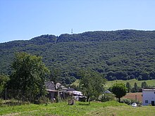
Jovice , Hungarian Jólész (1927-1948 Slovak "Jólész" - to 1927 "Joles") is a municipality in the east of Slovakia with 744 inhabitants (December 31, 2019), which for Okres Rožňava of, part kraj Košický heard.
geography
The community is located in the Slovak Karst in the Rožňavská kotlina basin , below the Silica Karst plateau to the south. The plateau is separated from the village itself by the small river Čremošná , which flows into the Slaná at Brzotín . The center of the village is at an altitude of 280 m nm and is five and a half kilometers from Rožňava .
Neighboring municipalities are Krásnohorské Podhradie in the north and northeast, Krásnohorská Dlhá Lúka in the east and southeast, Silica in the south, Brzotín in the southwest and west and Rožňava in the northwest.
history
Jovice arose around the turn of the 13th to 14th century on the territory of the nearby Krásna Hôrka castle and was first mentioned in writing in 1352 as Pachapataka . The current name appears in the form Jolees in 1427 ; in the same year the Bebek family owned 19 portals in town. In the 16th century were Vlachs settled in Jovice during the Wallachian colonization. In 1773 there lived 22 basic subjects, 11 unfree and eight Wallachians. In 1828 there were 66 houses and 395 inhabitants who were employed as farmers.
Until 1918/1919, the place in Gemer and Kleinhont counties belonged to the Kingdom of Hungary and then came to Czechoslovakia or now Slovakia. From 1938 to 1945 he was once again part of Hungary on the basis of the First Vienna Arbitration .
population
According to the 2011 census, Jovice had 726 inhabitants, including 546 Magyars , 130 Slovaks and 21 Roma . 29 residents did not provide any information on ethnicity .
439 residents committed to the Roman Catholic Church, 80 residents to the Reformed Church, 51 residents to the Evangelical Church AB, five residents to the Methodist Church and one resident each to the Jehovah's Witnesses and one to the Greek Catholic Church; one resident professed a different denomination. 93 inhabitants had no denomination and for 55 inhabitants the denomination was not determined.
Buildings and monuments
traffic
The 3rd order road 3012 runs through Jovice between Rožňava and Lipovník via Krásnohorská Dlhá Lúka. Furthermore, the village has a (currently not served) stop on the Košice-Barca-Rožňava railway . The nearest train station with regular passenger traffic is Rožňava, three and a half kilometers away.
Sons and daughters of the church
- András Cházár (1745–1816), Hungarian teacher, founder of the first school for deaf and dumb children in the Kingdom of Hungary
Individual evidence
- ↑ Results of the 2011 census (Slovak) ( Memento of the original from March 5, 2016 in the Internet Archive ) Info: The archive link was inserted automatically and has not yet been checked. Please check the original and archive link according to the instructions and then remove this notice.
Web links
- Entry on e-obce.sk (Slovak)


