Tornaľa
| Tornaľa Tornalja |
||
|---|---|---|
| coat of arms | map | |

|
|
|
| Basic data | ||
| State : | Slovakia | |
| Kraj : | Banskobystrický kraj | |
| Okres : | Revúca | |
| Region : | Gemer | |
| Area : | 57.765 km² | |
| Residents : | 7,114 (Dec. 31, 2019) | |
| Population density : | 123 inhabitants per km² | |
| Height : | 183 m nm | |
| Postal code : | 982 01 | |
| Telephone code : | 0 47 | |
| Geographic location : | 48 ° 25 ' N , 20 ° 20' E | |
| License plate : | RA | |
| Kód obce : | 515612 | |
| structure | ||
| Community type : | city | |
| Urban area structure: | 4 districts | |
| Administration (as of November 2018) | ||
| Mayor : | Anna Szögedi | |
| Address: | Mestský úrad Tornaľa Mierova 14 98201 Tornaľa |
|
| Website: | www.mestotornala.sk | |
| Statistics information on statistics.sk | ||
Tornaľa , Hungarian Tornalja (1948 to 1990 Slovak "Šafárikovo"; Hungarian formerly also Tornallya ) is a town in Okres Revúca ( Banskobystrický kraj ) in southern central Slovakia with 7114 inhabitants (as of December 31, 2019).
geography
The city is located in the eastern part of the Rimavská kotlina basin (part of the southern Slovak basin ) on the Slaná river south of Revúca near the Hungarian border, near the partial mountains of the Slovak Ore Mountains . The center of the village is at an altitude of 181 m nm and is 27 kilometers from Rimavská Sobota , 34 kilometers from Rožňava and 126 kilometers from Banská Bystrica (road distance).
The city is divided into the following parts of the municipality:
- Behynce (incorporated in 1971, Hungarian Beje )
- Králik (incorporated in 1963, Sajókirályi in Hungarian )
- Starňa (incorporated in 1971, Sajószárnya in Hungarian )
- Tornaľa
The following information relates to the straight line distance to the nearest town center and the distances are commercially rounded to half a kilometer. Cities are highlighted in bold.
|
Otročok , Tisovec 4.5 km, 40 km |
Gemer , Revúca 3 km, 33 km |
Dlhá Ves , Košice 11.5 km, 76.5 km |
|
Kaloša , Rimavská Sobota 7 km, 23 km |

|
Szuhafő (HU), Rudabánya (HU) 10 km, 23 km |
|
Stránska , Salgótarján (HU) 3.5 km, 54.5 km |
Štrkovec , Ózd (HU) 7 km, 22.5 km |
Hubovo , Kazincbarcika (HU) 4 km, 25.5 km |
history
The current municipality has been inhabited since the Bronze Age, with archaeological finds from the Kyjatice and Piliny cultures .
The place was first mentioned in writing in 1245 as Kuuy , and in 1291 as Tornalya alias Kewy . It was owned by the Tornallyai family and had 46 porta in a 1427 tax register . With the rise of the Tornallyai family , the importance of the place grew, and in 1513 it received some privileges from the Hungarian King Vladislav II . Because of the Turkish wars in the second half of the 16th century, many residents fled. In 1828 there were 96 houses and 622 inhabitants who were employed as craftsmen and farmers. After the railway connection in 1874 through the Bánréve – Dobšiná railway line , Tornaľa became the trading seat of the agricultural area.
Tornaľa belonged to the Kingdom of Hungary in Gemer and Kleinhont counties as the seat of a chair district until 1918 , then it came to the newly formed Czechoslovakia . She came back to Hungary for a short time from 1938 to 1945 through the First Vienna Arbitration .
The city was named from 1948 to 1990 in honor of the Slovak linguist Pavol Jozef Šafárik Šafárikovo .
population
According to the 2011 census, Tornaľa had 7509 inhabitants, of which 4,331 Magyars , 2,262 Slovaks , 334 Roma , 29 Czechs and five Bulgarians , Poles , Russians and Ukrainians . 10 inhabitants stated a different ethnic group and 523 inhabitants gave no information about the ethnic group .
3219 residents supported the Roman Catholic Church, 1254 residents the Reformed (Calvinist) Church, 426 residents the Evangelical Church AB, 133 residents the Jehovah's Witnesses, 62 residents the Evangelical Methodist Church, 60 residents the Greek Catholic Church, 12 Residents to the Old Catholic Church and 10 residents to the Orthodox Church; 53 residents professed a different denomination. 1288 inhabitants had no denomination and the denomination of 992 inhabitants was not determined.
Extract from the results of the 2001 census (8169 inhabitants):
|
By ethnicity:
|
By denomination:
|
Attractions
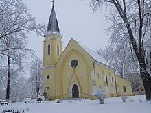
The most important sacred buildings are the Calvinist church in Gothic style from the 15th century, the Roman Catholic church in Neo-Gothic style from 1931 and the Protestant church in functionalist style from 1933. The districts of Behynce and Králik each have one calvinist church.
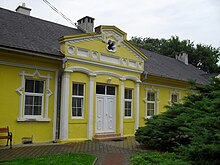
The former rural castle of the Tornallyai dynasty in the classical style from the early 19th century is now the seat of a children's home, and there is a rural castle in each of the districts of Behynce and Starňa. The city hall was built between 1926 and 1928. There are two monuments on the main square: one for the fallen Soviet soldiers and one for the victims of the city in World War II.
Regionally known is a bathing place near the river Slaná.
traffic
In the town, 1st order roads 16 ( Zvolen - Košice ) and 67 (HU / SK border near Kráľ - Rožňava - Pusté Pole) meet, and 2nd order road 532 branches off in Behynce towards Revúca and Muráň . Long-distance traffic uses the Tornaľa bypass completed in 2006 on the R2 expressway ( E 58 , E 571 ).
Tornaľa has had a connection to the railway network since 1874, with a train station east of the city center. There is no local public transport, only a few express trains on the so-called southern thoroughfare . The city has both long-distance and regional bus networks.
See also
Individual evidence
- ↑ Results of the 2011 census (Slovak)


