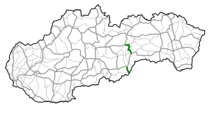
Cesta I. triedy 67
| Cesta I. triedy 67 in Slovakia | |||||||||||||||||||||||||||||||||||||||||||||||||||||||||||||||||||||||||||||||||||||||||||||||||||||||||||||||||||||||||||||||

|
|||||||||||||||||||||||||||||||||||||||||||||||||||||||||||||||||||||||||||||||||||||||||||||||||||||||||||||||||||||||||||||||
| map | |||||||||||||||||||||||||||||||||||||||||||||||||||||||||||||||||||||||||||||||||||||||||||||||||||||||||||||||||||||||||||||||

|
|||||||||||||||||||||||||||||||||||||||||||||||||||||||||||||||||||||||||||||||||||||||||||||||||||||||||||||||||||||||||||||||
| Basic data | |||||||||||||||||||||||||||||||||||||||||||||||||||||||||||||||||||||||||||||||||||||||||||||||||||||||||||||||||||||||||||||||
| Operator: | Slovenská správa ciest | ||||||||||||||||||||||||||||||||||||||||||||||||||||||||||||||||||||||||||||||||||||||||||||||||||||||||||||||||||||||||||||||
| Overall length: | 61.4 km without a common route | ||||||||||||||||||||||||||||||||||||||||||||||||||||||||||||||||||||||||||||||||||||||||||||||||||||||||||||||||||||||||||||||
|
Kraj : |
|||||||||||||||||||||||||||||||||||||||||||||||||||||||||||||||||||||||||||||||||||||||||||||||||||||||||||||||||||||||||||||||
| Road tunnel at Stratená | |||||||||||||||||||||||||||||||||||||||||||||||||||||||||||||||||||||||||||||||||||||||||||||||||||||||||||||||||||||||||||||||
|
Course of the road
|
|||||||||||||||||||||||||||||||||||||||||||||||||||||||||||||||||||||||||||||||||||||||||||||||||||||||||||||||||||||||||||||||
The Cesta I. triedy 67 ( Slovak for '1st order street 67'), I / 67 for short , is a 1st order street in Slovakia . It crosses the traditional Gemer landscape through the Slovak Ore Mountains (including Slovak Karst and Slovak Paradise ) and ends on the southeast slope of the Low Tatras . There is only one medium- sized town on the route, namely Rožňava .
On August 1, 2015, the section Pusté Pole – Polish border near Tatranská Javorina was incorporated into the extended road 1st order 66 .
course
The I / 67 begins at the former Kráľ-Bánréve border crossing in southern Slovakia and ends its (independent) south branch after 15 km in Tornaľa . After the joint course with the west-east road I / 16 through the Slovak Karst, it begins again in Rožňava , before going up to the town of Dobšiná through the upper Slaná valley. At Dobšiná it crosses the Dobšinský Kopec pass and continues through the Hnilec valley near the Slovak Paradise before it ends at Vernár at the Pusté pole junction.
Individual evidence
- ↑ Rozhodnutie MDVRR SR o usporiadaní cestnej siete (Decision of the Ministry of Transport, Building and Regional Development of the Slovak Republic on the organization of the road network) of July 23, 2015 , accessed on November 1, 2015
swell
- Description of the course of the road as of January 1, 2015 (Slovak) PDF file; 3.2 MB
- Note on the Stratená tunnel
- VKÚ as (ed.): Autoatlas 1: 100 000 - Slovenská republika . 9th edition. Harmanec 2012, ISBN 978-80-8042-636-1 .
