Cesta I. triedy 21
| Cesta I. triedy 21 in Slovakia | ||||||||||||||||||||||||||||||||||||||||||||||||||||||||||||||||||||||||||||||||||||||||||||||||||||||||||||||||

|
||||||||||||||||||||||||||||||||||||||||||||||||||||||||||||||||||||||||||||||||||||||||||||||||||||||||||||||||
| |
||||||||||||||||||||||||||||||||||||||||||||||||||||||||||||||||||||||||||||||||||||||||||||||||||||||||||||||||
| Basic data | ||||||||||||||||||||||||||||||||||||||||||||||||||||||||||||||||||||||||||||||||||||||||||||||||||||||||||||||||
| Operator: | Slovenská správa ciest | |||||||||||||||||||||||||||||||||||||||||||||||||||||||||||||||||||||||||||||||||||||||||||||||||||||||||||||||
| Overall length: | 58.6 km | |||||||||||||||||||||||||||||||||||||||||||||||||||||||||||||||||||||||||||||||||||||||||||||||||||||||||||||||
|
Kraj : |
||||||||||||||||||||||||||||||||||||||||||||||||||||||||||||||||||||||||||||||||||||||||||||||||||||||||||||||||
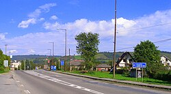
| The I / 21 in Kračúnovce | ||||||||||||||||||||||||||||||||||||||||||||||||||||||||||||||||||||||||||||||||||||||||||||||||||||||||||||||||
|
Course of the road
|
||||||||||||||||||||||||||||||||||||||||||||||||||||||||||||||||||||||||||||||||||||||||||||||||||||||||||||||||
The Cesta I. triedy 21 ( Slovak for, road 1st order 21 '), short- I / 21 , is a road of 1st order in Slovakia beginning at Lipníky and end at Vyšný Komárnik . It crosses the northeast of the country and generally runs northeast. It connects eastern Slovakia with eastern Poland through the Duklapass and is largely part of the European route 371 .
In the future it is to be replaced by the R4 expressway ; so far only the Svidník bypass has been implemented.
Until July 31, 2015, the street was numbered I / 73, which could alternatively be used until June 30, 2016.
course
The road begins at Lipníky as a junction of the 1st order road 18 from Prešov and runs through the Ondavská vrchovina , part of the Lower Beskids . In Giraltovce it crosses the Topľa river and climbs in a few hairpin bends at Šarišský Štiavnik . About 10 km before Svidník it crosses the Ondava and then reaches the town itself. 20 km after Svidník it ends at the Duklapass on the state border Slovakia-Poland at Vyšný Komárnik and goes into the Polish Droga krajowa 19 (DK19, until 2014 Droga krajowa 9 ) over.
Individual evidence
- ↑ Rozhodnutie MDVRR SR o usporiadaní cestnej siete (Decision of the Ministry of Transport, Building and Regional Development of the Slovak Republic on the organization of the road network) of July 23, 2015 , accessed on November 1, 2015
swell
- Description of the course of the road as of January 1, 2015 (Slovak) PDF file; 3.2 MB
- VKÚ as (ed.): Autoatlas 1: 100 000 - Slovenská republika . 9th edition. Harmanec 2012, ISBN 978-80-8042-636-1 .
