Cesta I. triedy 61
| Cesta I. triedy 61 in Slovakia | |||||||||||||||||||||||||||||||||||||||||||||||||||||||||||||||||||||||||||||||||||||||||||||||||||||||||||||||||||||||||||||||||||||||||||||||||||||||||||||||||||||||||||||||||||||||||||||||||||||||||||||||||||||||||||||||||||||||||||||||||||||||||||||||||||||||||||||||||||||||||||||||||

|
|||||||||||||||||||||||||||||||||||||||||||||||||||||||||||||||||||||||||||||||||||||||||||||||||||||||||||||||||||||||||||||||||||||||||||||||||||||||||||||||||||||||||||||||||||||||||||||||||||||||||||||||||||||||||||||||||||||||||||||||||||||||||||||||||||||||||||||||||||||||||||||||||
| map | |||||||||||||||||||||||||||||||||||||||||||||||||||||||||||||||||||||||||||||||||||||||||||||||||||||||||||||||||||||||||||||||||||||||||||||||||||||||||||||||||||||||||||||||||||||||||||||||||||||||||||||||||||||||||||||||||||||||||||||||||||||||||||||||||||||||||||||||||||||||||||||||||

|
|||||||||||||||||||||||||||||||||||||||||||||||||||||||||||||||||||||||||||||||||||||||||||||||||||||||||||||||||||||||||||||||||||||||||||||||||||||||||||||||||||||||||||||||||||||||||||||||||||||||||||||||||||||||||||||||||||||||||||||||||||||||||||||||||||||||||||||||||||||||||||||||||
| Basic data | |||||||||||||||||||||||||||||||||||||||||||||||||||||||||||||||||||||||||||||||||||||||||||||||||||||||||||||||||||||||||||||||||||||||||||||||||||||||||||||||||||||||||||||||||||||||||||||||||||||||||||||||||||||||||||||||||||||||||||||||||||||||||||||||||||||||||||||||||||||||||||||||||
| Operator: | Slovenská správa ciest | ||||||||||||||||||||||||||||||||||||||||||||||||||||||||||||||||||||||||||||||||||||||||||||||||||||||||||||||||||||||||||||||||||||||||||||||||||||||||||||||||||||||||||||||||||||||||||||||||||||||||||||||||||||||||||||||||||||||||||||||||||||||||||||||||||||||||||||||||||||||||||||||||
| further operator: | City of Bratislava | ||||||||||||||||||||||||||||||||||||||||||||||||||||||||||||||||||||||||||||||||||||||||||||||||||||||||||||||||||||||||||||||||||||||||||||||||||||||||||||||||||||||||||||||||||||||||||||||||||||||||||||||||||||||||||||||||||||||||||||||||||||||||||||||||||||||||||||||||||||||||||||||||
| Overall length: | 190.8 km | ||||||||||||||||||||||||||||||||||||||||||||||||||||||||||||||||||||||||||||||||||||||||||||||||||||||||||||||||||||||||||||||||||||||||||||||||||||||||||||||||||||||||||||||||||||||||||||||||||||||||||||||||||||||||||||||||||||||||||||||||||||||||||||||||||||||||||||||||||||||||||||||||
|
Kraj : |
|||||||||||||||||||||||||||||||||||||||||||||||||||||||||||||||||||||||||||||||||||||||||||||||||||||||||||||||||||||||||||||||||||||||||||||||||||||||||||||||||||||||||||||||||||||||||||||||||||||||||||||||||||||||||||||||||||||||||||||||||||||||||||||||||||||||||||||||||||||||||||||||||
| The I / 61 as the arterial road from Bratislava towards Senec | |||||||||||||||||||||||||||||||||||||||||||||||||||||||||||||||||||||||||||||||||||||||||||||||||||||||||||||||||||||||||||||||||||||||||||||||||||||||||||||||||||||||||||||||||||||||||||||||||||||||||||||||||||||||||||||||||||||||||||||||||||||||||||||||||||||||||||||||||||||||||||||||||
|
Course of the road
|
|||||||||||||||||||||||||||||||||||||||||||||||||||||||||||||||||||||||||||||||||||||||||||||||||||||||||||||||||||||||||||||||||||||||||||||||||||||||||||||||||||||||||||||||||||||||||||||||||||||||||||||||||||||||||||||||||||||||||||||||||||||||||||||||||||||||||||||||||||||||||||||||||
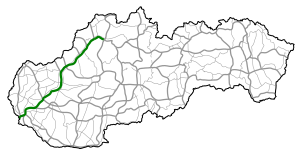
The Cesta I. triedy 61 ( Slovak for '1st order street 61'), I / 61 for short , is a 1st order street in Slovakia . It is located in the western part of the country and is now essentially the "old road" for long-distance traffic, as it has been completely replaced by highways. Larger cities besides the capital Bratislava are Trnava , the spa town Piešťany , Trenčín and Považská Bystrica and Žilina . In addition, the street can be referred to as “Waagtalstraße” because it follows the river Waag.
history
Until 1918 the area of today's Slovakia belonged to the Kingdom of Hungary , where there were no state roads until 1848. After the suppression of the Hungarian Revolution , the Austrian military administration took over responsibility for road construction in the occupied kingdom. In 1851 the Chamber of Commerce and Industry in Pressburg demanded the expansion of the most important streets in the Pressburg chamber district, including the street between Pressburg (Bratislava), Tyrnau (Trnava) and Sillein (Zilina). This street was taken over as Reichsstraße and in 1852 repaired to such an extent that its condition was described by the Chamber of Commerce and Industry as satisfactory.
On August 1, 2015, the Bytča – Žilina section was incorporated into I / 61, which was previously part of the simultaneously shortened I / 18.
course
The I / 61 begins at the former Petržalka-Berg border crossing as a continuation of the Austrian Pressburger Straße (B 9). Between the districts of Petržalka and Ružinov , it crosses the Danube at the harbor bridge , together with the D1 motorway . It leaves Bratislava near the Vajnory district and first runs through the Danube plain . From Senec it is located in the more hilly Danube hill country ; then it passes through the regional capital Trnava and from Madunice it runs parallel to the Waag . In this area you can also see the (partially decommissioned) Bohunice nuclear power plant .
The road then leads through the Piešťany spa town , while the landscape is now more hilly, surrounded by the Little Carpathians (from Nové Mesto nad Váhom White Carpathians ) in the west and the Inowetz (from Trenčín Strážovské vrchy ) in the east. Further north is the city of Nové Mesto nad Váhom. In the regional capital Trenčín with a castle that can be seen from afar , the street changes to the left bank of the Waag; Not far above the city is the (former) industrial area around Dubnica nad Váhom . Another industrial town passes after it - Považská Bystrica , it runs through the Waag Valley between the Javorníky Mountains to the west and the Súľovské vrchy to the east of the road. At Bytča it takes the I / 10 and ends in Žilina at the I / 60 .
Almost its entire course is parallel to the D1 motorway, which has gradually replaced I / 61; the last track replaced was in Považská Bystrica , where the motorway opened in May 2010.
swell
- Description of the course of the road as of January 1, 2015 (Slovak) PDF file; 3.2 MB
- VKÚ as (ed.): Autoatlas 1: 100 000 - Slovenská republika . 9th edition. Harmanec 2012, ISBN 978-80-8042-636-1 .
Individual evidence
- ↑ Communications from the field of statistics, Jg. 1854, p. 34.
- ^ Austria: newspaper for trade and commerce, public buildings and means of transport of March 12, 1853, p. 1.
- ↑ Rozhodnutie MDVRR SR o usporiadaní cestnej siete (Decision of the Ministry of Transport, Building and Regional Development of the Slovak Republic on the organization of the road network) of July 23, 2015 , accessed on November 1, 2015
