Cesta I. triedy 62
| Cesta I. triedy 62 in Slovakia | ||||||||||||||||||||||||||||||||||||||||||||||||||||

|
||||||||||||||||||||||||||||||||||||||||||||||||||||
| map | ||||||||||||||||||||||||||||||||||||||||||||||||||||

|
||||||||||||||||||||||||||||||||||||||||||||||||||||
| Basic data | ||||||||||||||||||||||||||||||||||||||||||||||||||||
| Operator: | Slovenská správa ciest | |||||||||||||||||||||||||||||||||||||||||||||||||||
| Overall length: | 37.3 km | |||||||||||||||||||||||||||||||||||||||||||||||||||
|
Kraj : |
||||||||||||||||||||||||||||||||||||||||||||||||||||
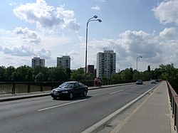
| Waagbrücke, viewing direction Sereď | ||||||||||||||||||||||||||||||||||||||||||||||||||||
|
Course of the road
|
||||||||||||||||||||||||||||||||||||||||||||||||||||
The Cesta I. triedy 62 ( Slovak for '1st order street 62'), I / 62 for short , is a 1st order street in Slovakia . It is located in the west of the country and runs from Senec via Sereď to Šintava .
course
The I / 62 begins at a junction near Senec with the I / 61 and is located on the Danube lowlands . It first runs east to Sládkovičovo , where it turns north-east to reach the town of Sereď . About 5 km after the Waagbrücke there , the road ends at a junction with the R1 expressway .
swell
- Description of the course of the road as of January 1, 2014 (Slovak) PDF file; 1.7 MB
- VKÚ as (ed.): Autoatlas 1: 100 000 - Slovenská republika . 9th edition. Harmanec 2012, ISBN 978-80-8042-636-1 .
