Cesta I. triedy 2
| Cesta I. triedy 2 in Slovakia | |||||||||||||||||||||||||||||||||||||||||||||||||||||||||||||||||||||||||||||||||||||||||||||||||||||||||||||||||||

|
|||||||||||||||||||||||||||||||||||||||||||||||||||||||||||||||||||||||||||||||||||||||||||||||||||||||||||||||||||
| map | |||||||||||||||||||||||||||||||||||||||||||||||||||||||||||||||||||||||||||||||||||||||||||||||||||||||||||||||||||

|
|||||||||||||||||||||||||||||||||||||||||||||||||||||||||||||||||||||||||||||||||||||||||||||||||||||||||||||||||||
| Basic data | |||||||||||||||||||||||||||||||||||||||||||||||||||||||||||||||||||||||||||||||||||||||||||||||||||||||||||||||||||
| Operator: | Slovenská správa ciest | ||||||||||||||||||||||||||||||||||||||||||||||||||||||||||||||||||||||||||||||||||||||||||||||||||||||||||||||||||
| further operator: | City of Bratislava | ||||||||||||||||||||||||||||||||||||||||||||||||||||||||||||||||||||||||||||||||||||||||||||||||||||||||||||||||||
| Overall length: | 100.9 km | ||||||||||||||||||||||||||||||||||||||||||||||||||||||||||||||||||||||||||||||||||||||||||||||||||||||||||||||||||
|
Kraj : |
|||||||||||||||||||||||||||||||||||||||||||||||||||||||||||||||||||||||||||||||||||||||||||||||||||||||||||||||||||
| Development condition: | 2 + 2: about 15 km in the Bratislava area | ||||||||||||||||||||||||||||||||||||||||||||||||||||||||||||||||||||||||||||||||||||||||||||||||||||||||||||||||||
| I / 2 in Bratislava-Petržalka (outer lanes) | |||||||||||||||||||||||||||||||||||||||||||||||||||||||||||||||||||||||||||||||||||||||||||||||||||||||||||||||||||
|
Course of the road
|
|||||||||||||||||||||||||||||||||||||||||||||||||||||||||||||||||||||||||||||||||||||||||||||||||||||||||||||||||||
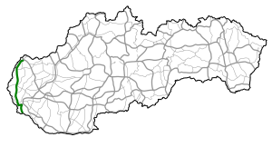
The Cesta I. triedy 2 ( Slovak for '1st order street 2'), I / 2 for short , is a 1st order street in western Slovakia . It leads through the far west of Slovakia from Holíč through the Záhorie landscape to the city of Malacky and on to the capital Bratislava , where it first touches the Little Carpathians and ends in Mlynská dolina. The Danube is crossed by the Lafranconi Bridge on the D2 motorway. It continues through the prefabricated Petržalka district from the north and east, before ending at the Hungarian border near Rusovce .
The line north of Bratislava runs almost parallel to the railway line (Bratislava–) Devínska Nová Ves – Skalica .
It is of little importance for international traffic because it has been replaced by the parallel D2 motorway . Before the introduction of the general truck toll in 2010, however, the majority of the route was subject to tolls under the vignette system for trucks in order to avoid avoiding the motorway.
history
Until 1918 the area of today's Slovakia belonged to the Kingdom of Hungary , where there were no state roads until 1848. The road between Pressburg and Hollitsch was classified as a Hungarian state road in 1854, which was supposed to be maintained by the local residents through unpaid work.
From 1918 to 1939 and from 1945 to 1993 it belonged to Czechoslovakia , whose street numbering was retained even after the independence of Slovakia.
Others
One of the few remaining cobblestone streets on the main roads in Slovakia ran through the municipality of Kúty . On this road built in 1928, however, there was a risk of accidents when it rained and, accordingly, had been a critical accident focus since 2005. After years of delays, this road was completely renovated in 2012 and re-paved with asphalt.
swell
- Description of the course of the road as of January 1, 2014 (Slovak) PDF file; 1.7 MB
- VKÚ as (ed.): Autoatlas 1: 100 000 - Slovenská republika . 9th edition. Harmanec 2012, ISBN 978-80-8042-636-1 .
Individual evidence
- ↑ Map of the motorways, expressways and 1st and 2nd order roads with toll roads
- ↑ Communications from the field of statistics, Jg. 1854, p. 34.
- ^ Directory of the state and state roads in the Pressburger, Oedenburger, Kaschauer and Großwardeiner administrative areas. LGBl. No. 19/1854, p. 99.
- ↑ Čadičové kocky na ceste v Kútoch nahradil asfalt , SME (Slovak), accessed on December 21, 2014
