Cesta I. triedy 13
| Cesta I. triedy 13 in Slovakia | ||||||||||||||||||||||||||||

|
||||||||||||||||||||||||||||
| |
||||||||||||||||||||||||||||
| map | ||||||||||||||||||||||||||||

|
||||||||||||||||||||||||||||
| Basic data | ||||||||||||||||||||||||||||
| Operator: | Slovenská správa ciest | |||||||||||||||||||||||||||
| Overall length: | 11.4 km | |||||||||||||||||||||||||||
|
Kraj : |
||||||||||||||||||||||||||||
| Danube border bridge between Medveďov and Vámosszabadi | ||||||||||||||||||||||||||||
|
Course of the road
|
||||||||||||||||||||||||||||
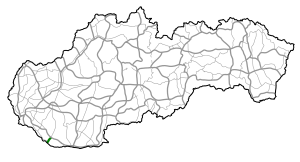
The Cesta I. triedy 13 ( Slovak for '1st order street 13'), I / 13 for short , is a 1st order street in Slovakia . It is located in the south-west of the country and runs from Veľký Meder to the Hungarian border at Medveďov. It is part of the European route 575 and was upgraded from the second order route 586 around 2003 .
course
The I / 13 begins at a crossroads at Veľký Meder with the 1st order road 63 and is located on the level Großer Schüttinsel . It passes the municipalities of Čiližská Radvaň and Baloň before reaching the border town of Medveďov . After a bridge over a branch of the Danube, the bridge over the main stream follows, at which the 1st order road 13 ends. After another 15 km in Hungary you reach the city of Győr .
swell
- Description of the course of the road as of January 1, 2014 (Slovak) PDF file; 1.7 MB
- VKÚ as (ed.): Autoatlas 1: 100 000 - Slovenská republika . 9th edition. Harmanec 2012, ISBN 978-80-8042-636-1 .
