Cesta I. triedy 77
| Cesta I. triedy 77 in Slovakia | |||||||||||||||||||||||||||||||||||||||||||||||||||||||||||||||||||||||||||||||||||||||||||||||||||||||||||||||||||||||||||||||||||||||||||||||||||||||||||||||||||||||||||||||||||||

|
|||||||||||||||||||||||||||||||||||||||||||||||||||||||||||||||||||||||||||||||||||||||||||||||||||||||||||||||||||||||||||||||||||||||||||||||||||||||||||||||||||||||||||||||||||||
| map | |||||||||||||||||||||||||||||||||||||||||||||||||||||||||||||||||||||||||||||||||||||||||||||||||||||||||||||||||||||||||||||||||||||||||||||||||||||||||||||||||||||||||||||||||||||

|
|||||||||||||||||||||||||||||||||||||||||||||||||||||||||||||||||||||||||||||||||||||||||||||||||||||||||||||||||||||||||||||||||||||||||||||||||||||||||||||||||||||||||||||||||||||
| Basic data | |||||||||||||||||||||||||||||||||||||||||||||||||||||||||||||||||||||||||||||||||||||||||||||||||||||||||||||||||||||||||||||||||||||||||||||||||||||||||||||||||||||||||||||||||||||
| Operator: | Slovenská správa ciest | ||||||||||||||||||||||||||||||||||||||||||||||||||||||||||||||||||||||||||||||||||||||||||||||||||||||||||||||||||||||||||||||||||||||||||||||||||||||||||||||||||||||||||||||||||||
| Overall length: | 96 km | ||||||||||||||||||||||||||||||||||||||||||||||||||||||||||||||||||||||||||||||||||||||||||||||||||||||||||||||||||||||||||||||||||||||||||||||||||||||||||||||||||||||||||||||||||||
|
Kraj : |
|||||||||||||||||||||||||||||||||||||||||||||||||||||||||||||||||||||||||||||||||||||||||||||||||||||||||||||||||||||||||||||||||||||||||||||||||||||||||||||||||||||||||||||||||||||
| I / 77 at the entrance to Zborov, coming from Bardejov | |||||||||||||||||||||||||||||||||||||||||||||||||||||||||||||||||||||||||||||||||||||||||||||||||||||||||||||||||||||||||||||||||||||||||||||||||||||||||||||||||||||||||||||||||||||
|
Course of the road
|
|||||||||||||||||||||||||||||||||||||||||||||||||||||||||||||||||||||||||||||||||||||||||||||||||||||||||||||||||||||||||||||||||||||||||||||||||||||||||||||||||||||||||||||||||||||
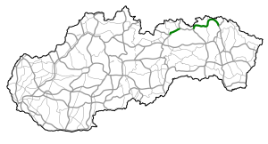
The Cesta I. triedy 77 ( Slovak for '1st order street 77'), I / 77 for short , is a 1st order street in Slovakia . It is located in the northeast of the country in the Spiš and Šariš landscapes and consists of two parts. The first part connects Spišská Belá with Stará Ľubovňa and the second part connects Ľubotín with Svidník via Bardejov .
course
The road begins in Spišská Belá at the intersection with the 1st order road 66 and first follows the Poprad valley to the northeast. After 10 km it reaches the small town Podolínec and after another 15 km the suburbs of Stará Ľubovňa , where the first part ends.
The second part begins at Ľubotín , heads east and follows the Poprad Valley again for about 10 km before crossing the northern foothills of the Čergov Mountains , copying the border with Poland . Then the road reaches the Topľatal . After about 25 km you will reach the town of Bardejov. The rest of the road is about 35 km long and over the northern slope of Ondavská vrchovina it reaches the town of Svidník via Zborov in a semicircle , where it ends.
expansion
The I / 77 is for the most part a two-lane, non-directional road, only in the local areas of Bardejov and Svidník it is partially expanded to four lanes.
In August 2016, the 5.3 km long southwest bypass of Bardejov was opened to traffic, which relieves the town center. The project was completed after around a year and a half of construction and cost around 33 million euros.
Individual evidence
- ↑ Motoristom sprístupnia juhozápadný obchvat Bardejova , Pravda (Slovak) from August 25, 2016, accessed on January 22, 2017
swell
- Description of the course of the road as of January 1, 2014 (Slovak) PDF file; 1.7 MB
- VKÚ as (ed.): Autoatlas 1: 100 000 - Slovenská republika . 9th edition. Harmanec 2012, ISBN 978-80-8042-636-1 .
