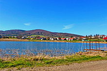
Smilno
| Smilno | ||
|---|---|---|
| coat of arms | map | |

|
|
|
| Basic data | ||
| State : | Slovakia | |
| Kraj : | Prešovský kraj | |
| Okres : | Bardejov | |
| Region : | Šariš | |
| Area : | 13.796 km² | |
| Residents : | 702 (Dec. 31, 2019) | |
| Population density : | 51 inhabitants per km² | |
| Height : | 447 m nm | |
| Postal code : | 086 33 ( Zborov post office ) | |
| Telephone code : | 0 54 | |
| Geographic location : | 49 ° 23 ' N , 21 ° 21' E | |
| License plate : | BJ | |
| Kód obce : | 519782 | |
| structure | ||
| Community type : | local community | |
| Administration (as of November 2018) | ||
| Mayor : | Vladimír Baran | |
| Address: | Obecný úrad Smilno č. 194 086 33 Zborov |
|
| Website: | www.smilno.sk | |
| Statistics information on statistics.sk | ||
Smilno (until 1927 Slovak "Smilno"; Hungarian Szemelnye - until 1907 Smilno ) is a municipality in the east of Slovakia with 702 inhabitants (December 31, 2019). It belongs to the Okres Bardejov , a Prešovský kraj district , and is part of the traditional Šariš landscape .
geography
The municipality is located at the northern end of the Ondavská vrchovina mountain range within the Low Beskids in the source area of the Ondava River , near the border with Poland . To the north of the village rises the " local mountain" Smilniansky vrch ( 749 m nm ). The center of the village is at an altitude of 447 m nm and is 13 kilometers away from Bardejov .
Neighboring municipalities are Becherov in the north, Jedlinka in the northeast, Mikulášová in the east, Cigla in the southeast, Šarišské Čierne in the south, Zborov in the west and Chmeľová in the northwest.
history
Smilno was first mentioned in writing in 1250 as Zemelnye and was then owned by the Aba family before it came to the Tekules in 1269 . For the next 95 years Smilno was the seat of a manor that comprised a total of ten villages; In 1364 it became part of the Makovica estate , which was ruled by the Czudar family. In 1427 a total of 45 porta are recorded, which at that time corresponded to a large village. But by the middle of the 15th century only 24 households were cultivating the arable land and in 1492 only ten.
Smilno was also shaped by the expansion of the country in the 16th century and subsequent influx of subject families. In 1711 there was a mass exodus of the inhabitants. In 1787 the village had 97 houses and 556 inhabitants, in 1828 there were 124 houses and 903 inhabitants who lived from agriculture and tobacco trade. During the First World War , the area was the site of several skirmishes and Smilno was also affected.
Until 1918, the place in Sharosh County belonged to the Kingdom of Hungary and then came to Czechoslovakia or now Slovakia.
population
According to the 2011 census, Smilno had 712 inhabitants, including 687 Slovaks, 4 Russians, 2 Czechs and 1 Ukrainian. 18 residents gave no information in this regard. 645 residents supported the Roman Catholic Church, 32 residents the Greek Catholic Church, 6 residents the Orthodox Church and 1 resident the Evangelical Church AB 8 residents were non-denominational and the denomination of 20 residents was not determined.
Buildings
- Roman Catholic St. Stephen's Church, originally built in the 13th century in Gothic style, redesigned in Baroque style in 1764. The current church was built in 1982-84.
traffic
Smilno is on the 1st order road 77 between Bardejov and Svidník . The nearest rail connection is in Bardejov on the Kapušany pri Prešove – Bardejov railway line .
Individual evidence
- ↑ Slovenské slovníky: názvy obcí Slovenskej republiky (Majtán 1998)
- ↑ 2011 census by ethnicity (Slovak) ( Memento from October 6, 2014 in the Internet Archive )
- ↑ 2011 census by denomination (Slovak) ( Memento from September 7, 2012 in the Internet Archive )
Web links
- Entry on e-obce.sk (Slovak)

